Monday, July 4, 2022

The Weirdest Chess Move, Part 2

This is the second part of a two-part post. For the first, see here.

In the previous post, I discussed some candidates for chess's weirdest move, where "move" here means a move written in algebraic chess notation. Our first two candidates, while rare, have come up in some historical games. Without further ado, here is chess's (notationally) weirdest move:

The weirdest move: Bf3g2#

At first glance, this looks rather innocent. It is a checkmate, but other than that it's just a bishop move, right? However, there's something strange here: both the starting square f3 and destination square g2 are listed for the bishop. Usually, only the destination square is listed in algebraic chess notation. But I'm not changing the notation rules here! There is a technicality that we'll use to our advantage.

The position above comes about in is a very common line in the Queen's Gambit Declined opening: 1. d4 d5 2. c4 e6 3. Nc3 Nf6 4.Bg5 Nbd7. Black has just played the move "Nbd7", moving the queen's knight from its home on b8 to d7, where it reinforces the pinned knight on f6. The notation "Nbd7" is used instead of "Nd7" because there are two black knights that could legally move to d7 on this fourth move! The other knight move would be denoted Nfd7 (a very bad move since white would win the queen). When additional information is required to disambiguate a move, chess notation rules hold that information must be provided about the piece's initial square. The way this information is provided is as follows:

Suppose that a player may move two or more of the same piece to the same square. Then the notation for the move must include one of the following three pieces of information:
  1. The file (column on the chess board, labeled a-h) where the piece originated, such as in the example Nbd7 above
  2. The rank (row on the chess board, labeled 1-8) where the piece originated, if specifying the file does not disambiguate the move
  3. Both the rank and file, only if neither the rank or the file alone can disambiguate the move
We saw an example of (1). As an example where (2) applies, see the following diagram:
Special notation disambiguating moves happens very frequently for rooks, because they are often "connected" on the same rank or file. In the above position, white has just played "R1h5". Both white rooks could move to h5, and they are both on the h file, so the originating rank (the first rank in this case) is provided before the destination square instead.

Though situations (1) and (2) are common enough, applying (3) is almost never necessary. This is because this would require one player to have at least three of the same piece, requiring a promotion of some kind. How rare is it for a player to have three of the same piece? Let's take a look at a few notable examples. There's a line where this can occur straight out of the opening: the famous Lasker Trap.

The game begins 1. d4 d5 2. c4 e5 3. dxe5 d4 4. e3 Bb4+ 5. Bd2 dxe3, arriving at the following position.


So far, only white's fourth move e3 can be considered a mistake, and not a major one. It appears that white can win a free piece by taking the bishop on b4, but this falls right into the Lasker trap! After 6. Bxb4, black responds with exf2+. In this position, white can't take the pawn, and must move the king to e2 (see below).


White has just played 7. Ke2. If white instead took the pawn with Kxf2, the king would no longer be protecting the queen and black wins with Qxd1. The winning move for black is now 7. ...fxg1=N+, underpromoting to a knight! This remarkable underpromotion occurs only seven moves into the game. If black promotes to a queen, the position is equal after white inserts Qxd8+, since after the white queen is captured, white can take the promoted piece on g1, leaving roughly equal material. This means that black must promote with check. After 7. ...fxg1=N+, If white takes the new knight with 8. Rxg1, the skewer 8. ...Bg4+ wins the white queen, so white plays 8. Ke1.


Black can then play 8. ...Qh4+, as shown above. White is lost here: they are down a piece, their king is completely exposed, and black's new knight will be saved. Most importantly for us, the final position features three black knights! They're nowhere near each other, though, so there's no need for disambiguating notation.

A few other quick examples of extra pieces: there have been a few historical games where a player had three queens (requiring two promotions!), and only one game I could find where a player had three rooks, see below. The game was a tournament game between Grigory Serper and Catalin Navrotescu in 1988.


In this position, black can promote and gain a huge material advantage. However, promotion to a queen results in a draw! This is because of a neat stalemate trick: white can perpetually check the black king with their two rooks. If the black king actually captures both, it's stalemate because the new queen on g1 takes away all squares from white's king, and both pawns are locked! Therefore, the winning move is "g1=R", which leaves five rooks on the board! The rook promotion was actually the last move of that game: white resigned. None of the games I found required rule (3) above to disambiguate a move, however.

Moreover, I could not find a single historical game in which one side had three bishops, which is the situation required for our candidate weirdest move. In fact, even more is required than that: one side needs to have three bishops of the same color for rule (3) to apply, which requires at least two bishop underpromotions!

This is the main idea behind my candidate for weirdest move, but I'll quickly run through the other features that led me to the specific choice of "Bf3g2#". First: the choice of squares.
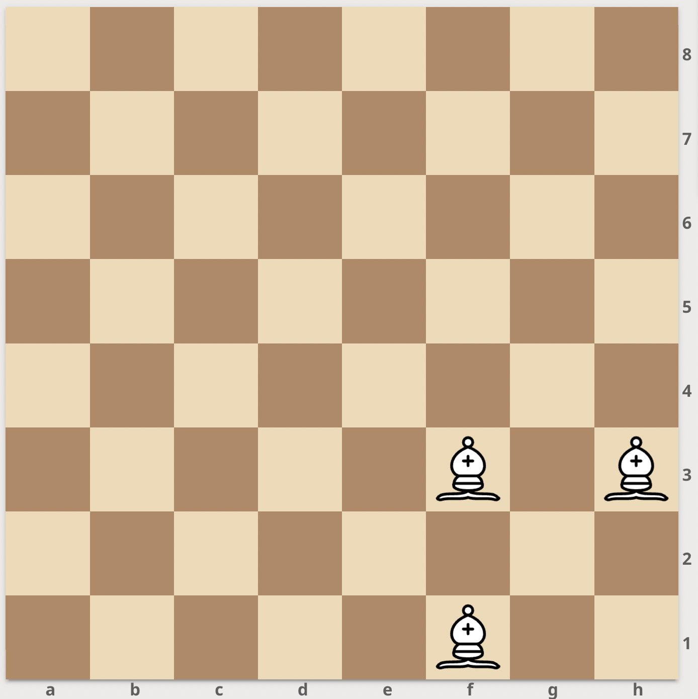


In order for rule (3) to be required to disambiguate, at least three bishops must be able to access the destination square. This means the square in question cannot be a corner or an edge square. The next most unusual choice is a square close to the corner such as g2, since this greatly constrains the positions of the bishops (all three must start among the four squares h1, h3, f1, f3; we'll use the configuration above). Further, the bishop that moves must be on the same file and the same rank as another bishop. We can't have the bishop move from h1, however, because it is impossible to deliver a checkmate with Bh1g2 if it is not a capture. This follows from the fact that the bishop does not attack any square it didn't before, and also could not have gotten out of the way of another piece. Therefore, if we stick to a checkmate without capture, the bishop that moves must start on f3, as shown.

The choice of corner (g2 instead of say, b2) is not particularly important, but with the white pieces is marginally weirder since the promoted bishops would have to retreat back toward white's side of the board and occupy the king's most common position (after kingside castle). Finally, let's consider the checkmate. In a similar vein to the comment above, after moving the bishop from f3 to g2, it doesn't attack any squares (not occupied by white pieces) that it didn't before. Since the move to g2 wasn't a capture, in particular, the bishop already saw the h1 square on the previous move. But then, how can this be a checkmate?

One can see that these conditions force the move to be a discovered checkmate, which is the final bit of weirdness; the bishop on f3 must be blocking a piece that then delivers checkmate to the enemy king. This setup feels even more contrived than having the bishop capture a piece to deliver checkmate, hence my choice of "Bf3g2#". Finally, just to prove that the move could happen, here's a (highly artificial) chess position using the move.

In this image, white has just delivered checkmate with our weirdest move, Bf3g2#.

This example serves to illustrate the huge variety of chess positions that have never been seen in a game before. Maybe this "weirdest move" will appear in a game someday. But I wouldn't bet on it.

Saturday, July 2, 2022

Tropical Storm Colin (2022)

Storm Active: July 2-3

Near the end of June, a tropical disturbance developed over the Bahamas and moved slowly northwestward. It wasn't very organized, but brought rain to the islands and to portions of the U.S. southeast coast by July 1. That day, a low-level circulation center did appear on satellite, located almost exactly on the coastline of Georgia. The atmospheric steering currents weren't particularly strong in the area and the low began to move northeast parallel to the coast as it rounded a high pressure area over the western Atlantic. Unexpectedly, the system maintained enough convection to be classified a tropical cyclone early on July 2. Since satellite data indicated that there were gale force winds off of the South Carolina coast, the system was named Tropical Storm Colin. When named, the center was actually a little bit inland over South Carolina!

Despite forming against the odds, Colin had a little too much to contend with: wind shear out of the west was ripping convection away from the center and the interaction with land further disrupted the cyclone. It steadily lost organization as it moved over North Carolina and ultimately dissipated early on July 3.


The above image shows Colin right after formation as a tropical storm.


Unusually, Colin spent all of its short time as a tropical cyclone (circle points) over land.

Friday, July 1, 2022

Tropical Storm Bonnie (2022)

Storm Active: July 1-2 (left Atlantic on July 2)

The end of June saw unusually favorable conditions in the tropical Atlantic for cyclonogenesis. One tropical wave took advantage of these conditions and began to organize. By June 27, the storm was quickly approaching the Windward Islands and was producing gale force winds, but did not have the closed circulation necessary to be a tropical storm. Its low latitude and fast forward speed toward the west prevented it from taking the final step to development at first. Land interaction compounded these issues the next day when it entered the Caribbean; it was so far south that it was skirting the northern coast of South America.

It was not until a few days later that the system moved into the southwestern Caribbean and again had an opportunity to develop. At last, on July 1, it was designted Tropical Storm Bonnie. By that time, the storm was less than a day from reaching land once again. Bonnie did strengthen somewhat during the day into a moderate tropical storm before making landfall near the border between Nicaragua and Costa Rica. Landfalls this far south in central America are fairly rare, particularly in this part of hurricane season; Bonnie became at the time the southernmost central America landfall for any July system of at least tropical storm strength.

The storm wasn't disturbed much by its passage over Nicaragua since it encountered mostly low-lying land. In fact, the center passed over Lake Nicaragua, which seemed to help preserve the circulation. On July 2, Bonnie emerged as a tropical cyclone into the eastern Pacific. Since the storm remained intact upon crossing from the Atlantic to the Pacific, it retained the name "Bonnie". This was the first time a storm crossed over and kept its name since Hurricane Otto in 2016. Conditions were favorable over water, and the system began to strengthen again. The cyclone developed an unusually large blob of convection to the west of the center that night, but its displacement from the center precluded rapid intensification.

Bonnie was a large cyclone over warm waters, so the wind shear wasn't enough to prevent it from gradually gaining strength. On July 3, it strengthened to a hurricane. The eyewall continued to get better defined and and eye even appeared on July 4, when the system was upgraded to a category 2. It peaked the next day as a category 3 major hurricane. Meanwhile, the storm was on a very steady heading toward the west-northwest. Soon after, however, wind shear and cooler waters began to weaken the system. It slowly decayed for several days before becoming post-tropical on July 9. The remnants dissipatd a few more days after that.


The above image shows Bonnie just before landfall in central America. After traversing the narrow isthmus, it emerged into the Eastern Pacific intact.


Bonnie achieved major hurricane status after moving into the Pacific.

*Note: Bonnie is listed as a tropical storm active from July 1-2 in the post's title because this was the peak intensity it achieved while in the Atlantic basin. It only became a hurricane in the eastern Pacific and is therefore counted as a tropical storm in season totals.

Thursday, June 30, 2022

The Weirdest Chess Move

This post will attempt to answer the question: "What is the weirdest possible chess move?"

More specifically, we'll consider all possible chess move notations, using standard algebraic chess notation. So among possible written moves such as "Ne6", "Qxd7", etc., we want to decide which is the most unusual. I could imagine two different ways of making "weirdest" more precise.

  1. Consider the list of all possible chess games (using standard rules), written down using standard chess notation. Which move notation occurs the fewest number of times in all possible games?
  2. Look at all tournament chess games (with standard rules, etc.) that have occurred in history. Alternatively, let a powerful chess engine such as Stockfish play itself many times and write down all the games. Which move notation occurs with the lowest frequency?
Approach (1) is at least a well-defined question, because the number of chess games is finite, though incredibly large. The reason for this is that by the 50-move rule, any chess game in which there is no capture or pawn advance in 50 moves in automatically a draw; thus pieces cannot shuffle around the board forever and every game must end. One estimate for the number of possible chess games is known as the Shannon number, named after the mathematician Claude Shannon. The estimate is 10120, which vastly exceeds even the number of atoms in the observable Universe! Therefore, it's impossible in practice to enumerate all chess games.

Approach (2) is a little better, but if we use only games that have actually occurred, or a computer sample size small enough to be computationally feasible, it might be too small for any of the "weirdest" moves to appear (we'll see this later). Moreover, we've made some choices about what a sample of representative "good" chess games might look like. I prefer approach (2), though, since the spirit of the challenge is to find what moves come up the least often in a game where both players play sensibly. In any case, my proposed "weirdest move" has not happened in any game that I could find.

The question I'm considering is a little unusual. Instead of looking at possible chess positions, the problem only asks about how a particular move is written down, so the only information we get about the position is from what the notation conveys. This includes the piece moving, the destination square, whether the move is a capture, whether it delivers a check or checkmate, etc.


For example, in the above position, black has just made the move "Nxf3+". The "N" indicates the knight has moved, "f3" is the destination square, "x" means the move was a capture, and the "+" means that the move delivers a check (but not checkmate). However, if we only see the symbols "Nxf3+" in isolation, we don't know what other pieces are on the board, where the knight came from, or where exactly the enemy king is (just that it's in range of the knight's attack).

There are some other notations for special moves in chess, such as castling: kingside castling is denoted "O-O", and queenside castling "O-O-O". The promotion of a pawn is denoted by an "=" sign, for example "e8=Q". In constrast, en passant does not have a special symbol in standard notation.


The above image shows a position after black plays "a5". This is an opportunity for white to capture en passant, meaning that white's b-pawn can move to a6 and capture the black pawn on a5 on the next move as if it had moved one square instead of two. However, this is notated simply "bxa6", so if we only know the notation and not the position, we can't distinguish en passant from an ordinary pawn capture.

Let's try a few weird moves. We'll start with castling. Castling on its own happens in almost every game, but it is usually a move to improve king safety in the opening, so it is almost unheard of to check or checkmate with a castling move. Hence, we have our first candidate weirdest move:

Candidate 1: O-O-O#

The notation here means: queenside castle and checkmate. It's an incredibly rare move, but it (nearly) happened in a high-profile historical game! In a 1912 game between international master Edward Lasker (distantly related to world chess champion Emanuel Lasker) and twice British chess champion George Alan Thomas, the following position was reached after black's 17th move, "Kg1".


Lasker had the opportunity to play checkmate in one move with "O-O-O#", our candidate weirdest move! He instead played "Kd2#", which is still checkmate since it allows the white rook on a1 to see the enemy king. Moving the king to deliver checkmate is already a bit uncommon, but the queenside castle would have been stranger still. You might be wondering how on earth the black king arrived on g1 in this game! It was in fact the culmination a remarkable series of forced moves in which the black king went from g8 to g1. The full game is well worth checking out (see here for an explanation of the full game).

Therefore, queenside castle checkmate is rare, but it did almost occur in a game involving two very high caliber players, so maybe we can do better. There's another uncommon move type that's natural to try: underpromotion.

When a pawn reaches the end of the board, it can become a queen, but the player also has the option to trade their pawn for a different piece instead (rook, knight, or bishop). This is called an underpromotion. Since the queen is the most powerful piece in chess, there are very few cases in which a player would "legitimately" underpromote, i.e. where the underpromotion is a superior move to promotion to a queen. Most occurrences of underpromotion in real games are "just for fun", for example when the promoted piece would be captured either way. However, there are some exceptions.


The above position occurred in a game between Vladlen Zurakhov and Alexander Koblents in a 1956 USSR semifinal event. Koblents has just played his knight to f5 and is threatening to win the pawn on g7, which would bring the game to a knight vs. two pawns position that is a theoretical draw. Therefore, white must promote the g pawn. However, if white plays "g8=Q", black will simply win the queen by forking the queen and king with the move "Ne7+". The only move that wins for white is "g8=N", an underpromotion to a knight. This defends against the fork, and the new knight can go on to help one of the two remaining pawns to queen promotion (this is still a difficult win, but Zurakhov did end up winning the game). Since knights can move and attack in ways that queens cannot, it makes sense that knight underpromotions are sometimes practical. Indeed, promoting to a knight is next most common after promoting to a queen. This leads us to our second candidate:

Candidate 2: Bishop underpromotion (e.g., "a8=B")

The rarest underpromotion of all is to a bishop. The bishop's value in chess is roughly equal to the knight's as the lowest of the (non-pawn) pieces, and unlike a knight, the bishop does not move in a way that the queen cannot. In particular, I didn't include a "#" (checkmate symbol) on the example move in Candidate 2, because if a bishop promotion move comes with checkmate, the same move with a queen promotion instead would also be mate. Therefore, no "legitimate" underpromotion occurs that way. I could also have made the move a check or capture, but this makes relatively little difference.

Though some endgame compositions have featured this type of move, there are once again precious few examples in real games. One of the only ones on record is in the following game between Aron Reshko and Oleg Kaminski in the 1972 Leningrad chess championship.


In this position, it's white to move. Though Reshko has a pawn close to promotion, Kaminski has a trick up his sleeve. First, if white does not address the threat on the a7 pawn, the black queen will simply win it in the next move, leading to equal material and a likely draw. If white moves to protect the pawn on its current square by taking the queen to a4 or b8, black can play the queen to f7 for checkmate!

Therefore, white must promote the pawn (or throw in a check with "Qg6+", but the queen must simply return and this gains nothing). However, promotion to a queen or a rook lead to an immediate draw because of black's defensive resource "Qf7+", sacrificing the queen! White's only move is to take the queen, and the resulting position is stalemate, a draw.


The above image shows the hypothetical variation 61. a8=Q Qf7+ 62. Qxf7. Though white is now up two full queens, black has no legal moves and the game is a draw by stalemate. A rook on a8 would also guard the h8 square, so it's again stalemate. Promoting to a knight in the initial position avoids this problem, but it's not too hard to see that the knight can't escape the corner without black's queen capturing it. The only winning strategy, which Reshko found in this position, is to promote to a bishop. Soon after, the players traded queens, and with an extra bishop, white went on to win.

While the bishop underpromotion is the rarest type of move in chess, it is not the weirdest move in terms of notation. I'll reveal my pick for the game's weirdest move in the next post.

Sunday, June 5, 2022

Tropical Storm Alex (2022)

Storm Active: June 5-6

During the last week of May, a tropical cyclone developed southwest of Mexico and became Hurricane Agatha, the first named storm of the Eastern Pacific hurricane season. On May 30, it made landfall as a category 2 hurricane in the Mexican state of Oaxaca. It caused widespread flooding in southern Mexico but the low-level center quickly dissipated over the mountainous terrain. Nevertheless, the remnants moved generally northeastward toward the Gulf of Mexico.

There was significant wind shear over the region, which prevented reformation at first. There were also two areas of vorticity: one was the remnants of Agatha, and another upper-level low farther east. It took time for these areas to consolidate. Despite this, the disturbance was quite vigorous. By June 3, when it was centered just north of the Yucatan Peninsula, the low was already producing gale force winds. The next day, it made landfall in southwestern Florida, bringing tropical storm force winds and heavy rain to the southern half of the state.

It wasn't until after the system moved east-northeastward over the open Atlantic that it finally became organized enough to be designated Tropical Storm Alex early on June 5. Alex was named quite soon after the official start of hurricane season on June 1, but 2022 was actually the first time since 2015 that there was no named storm prior to June 1.

The storm strengthened over the Gulf stream during the day and became a strong tropical storm by the evening. Alex reached a peak intensity of 70 mph winds and a minimum central pressure of 984 mb that night. Soon after, it encountered colder waters and higher shear, which weakened the cyclone and hastened its extratropical transition. Before it finished this transition, however, Alex passed just north of Bermuda early on June 6, bringing tropical storm conditions to the island. Alex was designated post-tropical later that day. The remnants merged with another low over the Atlantic just one day later.


The above image shows Alex intensifying over the western Atlantic. The U.S. east coast is visible at left.


The low that became Alex brought gale conditions to southern Flroida on June 4, but it was not yet a tropical cyclone at the time.

Tuesday, May 17, 2022

Professor Quibb's Picks – 2022

My personal prediction for the 2022 North Atlantic Hurricane season (written May 17, 2022) is as follows:

20 cyclones attaining tropical depression status,
19 cyclones attaining tropical storm status,
9 cyclones attaining hurricane status,
5 cyclones attaining major hurricane status.

This prediction is well above the 1991-2020 averages of 14.4 tropical storms, 7.2 hurricanes, and 3.2 major hurricanes each season in the Atlantic basin. I expect that 2022 will thus be the third consecutive season with significantly above-average activity. Below, I'll discuss the various factors involved in making this prediction.

The first factor to consider is, as always, the El Niño Southern Oscillation (ENSO) index, which is a numerical measure of sea surface temperature anomalies in the equitorial Pacific ocean. When these waters are warmer than normal (El Niño), Pacific tropical cyclone activity is elevated and Atlantic activity is suppressed. When they are cooler (La Niña), the reverse is true. Remarkably, La Niña conditions are expected to persist through the summer, making 2022 the third consecutive La Niña year! The graphic below shows various model predictions for the ENSO index through the rest of the year. The official threshold for a La Niña event is -0.5, and the index is expected to linger near or below this threshold by a majority of models.
Once again, it seems likely that La Niña will give this year's activity a significant boost.

The map below shows current sea surface temperature anomalies in the Atlantic. They are mostly above average, though no region in particular stands out too much. Note that sea surface temperature anomalies are generally measured relative to a mean based on the last few decades. Therefore, this does not account for anthropogenic ocean warming; measured against pre-industrial levels, these anomalies would be greater.


Until May, the main developement region (between the western African coast and the Caribbean) actually had somewhat below average sea surface temperatures. Recently, however, the east-to-west trade winds have relaxed. When trade winds are strong, they churn up cooler ocean waters from below the surface; they also directly inhibit cyclone formation by making it hard for vortices to form (see here for more). Therefore, recent trends are concerning, as the eastern Atlantic has warmed significantly in the last month. If this continues, long-track hurricanes are likely by the heart of the season. Finally, we'll take a look at the following prediction for wind shear anomalies in the first half of hurricane season (June-July-August).


Blue indicates below-average wind shear and hence more favorable conditions for hurricanes to form. The signal in this model is quite strong; it seems likely that the Caribbean in particular will have little wind shear during early hurricane season. Note that below-average shear is consistent with a La Niña pattern, but this doesn't occur everywhere: in the deep tropics near Africa, there's an area of above-average shear. In this model, the region of above-average shear even drifts northward as the summer progresses. Nevertheless, almost all factors point to a quite active hurricane season.

Using these and a few other factors, I'll give a finer analysis of the risks by region. My estimates are on a scale from 1 (least risk) to 5 (most risk).

U.S. East Coast: 4
Most areas are at above-average risk this year, and the east coast is no exception. The good news is that I expect most of the cyclones forming in the main development region during August and September will curve out to sea, since the shear pattern favors the consolidation of tropical waves more at their northern ends. Storms forming closer to home will be the ones to watch for.

Yucatan Peninsula and Central America: 4
The monsoon in this region is currently quite active. This elevates the risk for some messy tropical storms near central America in late May and June, with flooding and mudslides the main concern. It's difficult to say this early, but October and November may also be an active time for the western Caribbean.

Caribbean Islands: 4
All the general factors discussed above also suggest the Caribbean will be at elevated risk, but I don't see anything specific pointing to tracks through the islands. I do expect an early start to activity in the region, with multiple storms by the time August comes around.

Gulf of Mexico: 5
The Gulf coast has experienced an exceptional number of hurricane landfalls already during the 2020 and 2021 seasons. With the La Niña continuing, this is unlikely to abate this year, unfortunately. The atmospheric setup on models this year also seems to favor steering cyclones into the Gulf, should they form in the Caribbean. This merits a maximum risk designation.

Overall, I expect the 2022 Atlantic hurricane season to be well above average. Nevertheless, this is just an amateur forecast. Individuals in hurricane-prone areas should always have emergency measures in place. For more on hurricane safety sources, see here. Remember, devastating storms can occur even in otherwise quiet seasons.

Sources: https://www.cpc.ncep.noaa.gov/products/analysis_monitoring/lanina/enso_evolution-status-fcsts-web.pdf, https://www.tropicaltidbits.com, https://www.trackthetropics.com/saharan-air-layer-sal-tracking/, https://www.nhc.noaa.gov/sst/

Saturday, May 14, 2022

Hurricane Names List – 2022

The name list for tropical cyclones forming in the North Atlantic basin for the year 2022 is as follows:

Alex
Bonnie
Colin
Danielle
Earl
Fiona
Gaston
Hermine
Ian
Julia
Karl
Lisa
Martin
Nicole
Owen
Paula
Richard
Shary
Tobias
Virginie
Walter

This list is the same as that for the 2016 season, with the exception of Martin and Owen, which replaced the retired names Matthew and Otto, respectively.

Saturday, January 1, 2022

Zodiacal Light

Looking east on a clear night, just before sunrise, a glow extends upward from the horizon. This light lingers, coexisting with the stars, before a brighter band of sky appears along the horizon, the Sun itself not far behind. Long exposure photography shows the phenomenon clearly, such as in the left side of the image below (the glow of the Milky Way galaxy is also visible on the right).


Astronomers first noticed the subtle first light, known as zodiacal light, centuries ago. In fact, identifying this phenomenon has been important to the practice of Islam. The fajr, or dawn prayer, is required before sunrise every day, but how long before? Unlike noon and sunset, the time of dawn is harder to pin down precisely.

The phenomenon of zodiacal light was significant enough to be named in the teachings of the Islamic prophet Muhammad: it was called "the false dawn", al-fajr al-kazib, to be distinguished from the later "true dawn", al-fajr as-sadiq. The latter time is widely accepted to be the correct one for the dawn prayer.

But what causes this light? In some ways, the cause is mundane: astronomers have long known that the glow originates from sunlight reflecting off of small dust particles in space. The long-narrow shape of the glow occurs because dust is not distributed uniformly throughout interplanetary space. Nearly all objects orbiting the Sun, from the largest planets to the smallest dust particles, cluster near a single plane, the plane of the Solar System. In our night sky, this plane appears as a line known as the ecliptic, along which the planets, Sun, and Moon travel. In turn, the constellations on the ecliptic are known as the zodiac. Voilà! Zodiacal light! Though most pronounced near the Sun at dawn, dim zodiacal light can be observed on a moonless night to follow the entire ecliptic.

However, this explanation merely raises another question. Where does the dust come from? Some debris comes from comets and asteroids, but some more evidence recently surfaced on this subject from an unlikely source.


On August 5, 2011, the NASA spacecraft Juno launched from Earth, the beginning of its five-year journey to Jupiter. Elsewhere on this blog, I've written in depth about Juno's mission and its many discoveries orbiting the Solar System's largest planet. However, the probe began gathering important data long before reaching its destination. Along its trajectory (pictured above*), Juno returned to Earth for a gravity assist to give it a boost to Jupiter. During its journey, scientists on the Juno team noticed something alarming: thousands of tiny streaks of light appeared on images of what should have been empty space!

Further analysis revealed that the streaks were tiny bits of debris knocked from Juno's solar panels, dislodged by microscopic dust particles impacting at high velocities. Unintentionally, the large solar panels of Juno became a interplanetary dust collector! Fortunately, the impacts were not large enough to cause damage detrimental to the mission, but they did reveal a surprising story.


In all, over 15,000 dust impact events were recorded, enough to measure in unprecendented detail the distribution throughout the inner Solar System. The figure above* (click to enlarge) shows the data. The top panel shows events on Juno's inbound stage from the farthest point of its first orbit (on the trajectory image, the point marked DSM or "Deep Space Manuever") to Earth flyby. The second shows impacts recorded outbound from Earth flyby through the asteroid belt, on its way to Jupiter. The horizontal axis measures distance from the Sun, while the black line indicates frequency of imapct events. For context, various significant distances and the distribution of asteroids (gray) in the asteroid belt are also included.

As a bonus, the outbound portion of the trajectory shown above was tilted from the ecliptic plane, while the inbound one lay within it (see again the trajectory image). Hence, we can clearly see that less impacts occur away from the plane of the Solar System. It is also clear that the impacts are reduced near Earth, since our planet's gravitational influence "clears its orbit" of dust. Nevertheless, it is the dust closest to us that causes most of the zodiacal light we observe.

In contrast, the vicinity of Mars appears riddled with dust, even more so than some parts of the asteroid belt! This was a great surprise, for it was expected most of the dust was from asteroids and that Mars would clear its orbit, just like Earth does. However, further data analysis confirmed that Mars must in fact be a major source of the dust that ultimately causes zodiacal light! There is much more to be discovered about this story: what mechanisms cause Mars to lose so much dust to space? Currently, the answer is not definitively known, though further space missions could provide clues. But after thousands of years of mystery, at least we now know that when we see that before-dawn glow, we have the red planet to thank.

Sources: https://www.al-islam.org/articles/al-fajr-sadiq-new-perspective-sayyid-muhammad-rizvi, https://earthsky.org/astronomy-essentials/everything-you-need-to-know-zodiacal-light-or-false-dusk/, https://agupubs.onlinelibrary.wiley.com/doi/epdf/10.1029/2020JE006509, https://www.jpl.nasa.gov/news/serendipitous-juno-detections-shatter-ideas-about-origin-of-zodiacal-light

*The last few figures in this post are from the paper "Distribution of Interplanetary Dust Detected by the Juno Spacecraft and Its Contribution to the Zodiacal Light" by J. Jorgensen et al.

Monday, December 13, 2021

2021 Season Summary

The 2021 Atlantic hurricane season was quite active, with a total of

21 cyclones attaining tropical depression status,
21 cyclones attaining tropical storm status,
7 cyclones attaining hurricane status, and
4 cyclones attaining major hurricane status.

Before the beginning of the season, I predicted that there would be

17 cyclones attaining tropical depression status,
16 cyclones attaining tropical storm status,
8 cyclones attaining hurricane status,
5 cyclones attaining major hurricane status.

The average numbers of tropical storms, hurricanes and major hurricanes (over the 30 year period 1991-2020) were 14.4, 7.2, and 3.2, respectively. This puts the 2021 season a bit above average overall, with a much higher than usual number of named storms but near average numbers of hurricanes and major hurricanes. Likewise, my predictions underestimated the number of named storms, but were close on hurricanes and major hurricanes. The 21 named storms were the third-most recorded for an Atlantic season at the time, behind 2020 and 2005. The Accumulated Cyclone Energy (ACE) value for the 2021 season (which accounts for duration and intensity of storms as well as number) was roughly 145, once again above normal but not by a huge margin. The exact figure will likely shift slightly in post-season analysis.

A bevy of short-lived, weak systems inflated the total number for the season, especially early on. There were three named storms in June for the first time since 1968. Hurricane Elsa set a record for earliest fifth named storm when it was named on July 1. However, the end of the season was surprisingly quiet. With the exception of meandering Tropical Storm Wanda, which spent a week in early November moving around the north Atlantic, there was no activity from October 4 onward. This is quite unusual: on average, one would expect around 3 named storms and at least 1 hurricane during that time. Even stranger, the entire world experienced a lack of strong cyclones during October and November 2021. To explain this behavior, we'll examine a few factors.


At the beginning of the season, an ongoing La Niña event was on the wane, and indeed it officially ended over the summer. However, equatorial Pacific sea temperature anomalies remained negative (consistent with La Niña) and even began to decrease again by late in the year. The relevant regions of the Pacific and their temperature anomalies throughout the year are illustrated above. Overall, the weak La Niña that occurred was consistent with pre-season predictions. It is correlated with lower wind shear in the Atlantic and thus consistent with the somewhat above normal activity observed. Likewise, the tropical north Atlantic had fairly warm ocean temperatures, which helped tropical cyclones to form and intensify. However, this doesn't explain why the Atlantic shut down in October.


2021 featured a particularly strong west African monsoon; note the high precipitation over Africa around 10° N or so between June and August in the map above. This is signficant because tropical waves, the precursors to most Atlantic tropical cyclones, form over Africa and move westward into the Atlantic. Indeed, in contrast to 2020, a larger proportion of storms originated in the tropical Atlantic (see the map of storm tracks below):

Every year, the opportunity for cyclone formation off of Africa closes in early October, when the wave axis shifts toward the equator and east Atlantic temperatures start to get cooler. The center of activity usually then shifts to the Caribbean, but the Caribbean saw an unusual amount of dry sinking air late in the year, stifling any formation. This is again in stark contrast to 2020, when the west Caribbean saw its most active period in recorded history from October through November. These factors help to indicate why the 2021 season ended earlier than expected.

In my predictions, I put the Caribbean islands and the Gulf of Mexico at highest risk, with the U.S. east coast and central America at lower risk. These predictions were fairly good: Hurricane Elsa, Tropical Storm Fred, Hurricane Grace, and Hurricane Ida impacted the Caribbean Islands, while Ida and Hurricane Nicholas had the greatest Gulf impacts (though Grace also hit the Yucatan and the southwest Gulf). The Caribbean impacts might have been greater still had some of the above storms not tracked directly over the greater Antilles. No landfalls occurred in central America and only the extremely unusual Henri had any significant impact on the U.S. east coast as a tropical cyclone.

Some other notable facts or records from 2021 include:
  • Tropical Storm Ana's formation on May 22 made 2021 the seventh consecutive season with a named storm before June 1
  • Elsa was the easternmost forming early July hurricane in the tropics since 1933; it also had the highest forward speed of any known Atlantic hurricane in the tropics
  • Grace's remnants reformed as a tropical storm in the eastern Pacific and were named Marty
  • Henri was the slowest-moving cyclone ever recorded in the U.S. northeast; this led to unusual flooding impacts in the region
  • Ida tied 2020's Hurricane Laura for highest winds of a landfalling Louisiana hurricane (150 mph)
Finally, Hurricane Sam was the season's strongest storm, with winds of 155 mph and a central pressure of 929 mb. It was a long-lived and powerful storm, clocking in at over 50 ACE just on its own and holding major hurricane status for 7.75 consecutive days. Despite this, it went out to sea and didn't significantly impact any landmasses.

The 2021 season was quite active, though with many weak systems. The vast majority of the season's damage and loss of life were due to Hurricane Ida, which made landfall in Louisiana as a category 4 hurricane.

Sources: https://www.washingtonpost.com/weather/2021/11/22/earth-hurricane-activity-record-quiet/, https://www.cpc.ncep.noaa.gov/products/analysis_monitoring/lanina/enso_evolution-status-fcsts-web.pdf

Tuesday, November 2, 2021

Tropical Storm Wanda (2021)

Storm Active: October 30-November 7

On October 25, an early-season nor'easter formed off the United States east coast. The low deepened rapidly over the next day and brought hurricane-force wind gusts to coastal Massachusetts, but it was a non-tropical system. The system meandered near the coast for another day before slowly retreating eastward over the open Atlantic. It remained an intense low for the next several days, but was still attached to a frontal boundary. The low moved turned southeastward on the 27th and pursued that heading for a few days until it encountered warmer waters. Late on the 30th, the cyclone was classified as Subtropical Storm Wanda; it had more central convection and a tighter windfield, but was still interacting with nearby fronts.

After formation, Wanda slowed down and meandered across the open central Atlantic. Meanwhile, the cyclone was separating further from the nearby upper-level low. It transitioned into a fully tropical storm on November 1.

Wanda turned northward and made some steady progress in that direction over the next few days, following a trough to its north. The convective structure remained somewhat subtropical in appearance, with curved bands north and west of the center, but little in the way of deep central convection. However, on November 4, a ridge built to the north of Wanda and turned it back southeastward, in the general direction of the Azores.

By November 6, Wanda began to feel the pull of a powerful cyclone over the north Atlantic. It turned back to the northeast and began to accelerate, passing northwest of the Azores. The cyclone encountered high shear and colder waters and transitioned to an extratropical cyclone on the 7th.


The above image shows Wanda on November 3 over the open Atlantic.


Wanda took a meandering track over the north Atlantic, beginning as an extratropical low near the Eastern seaboard and ending past the Azores.