Wednesday, September 29, 2021

Tropical Storm Victor (2021)

Storm Active: September 29-October 4

On September 27, a tropical wave moved off of Africa into the eastern Atlantic. It was located on the eastern edge of a monsoonal trough of low pressure, while another tropical wave was situated on the western end. For a few days, these disturbances battled it out, but the eastern one ultimately became dominant and organized into Tropical Depression Twenty on September 29. It was located in quite favorable conditions, but its large size kept strengthening gradual. The depression became Tropical Storm Victor later that day. It was the second earliest formation of a twentieth named storm on record, behind only Vicky of the previous year, which formed on September 14. Victor was named at an unusually low latitude for the Atlantic at 8.3° N.

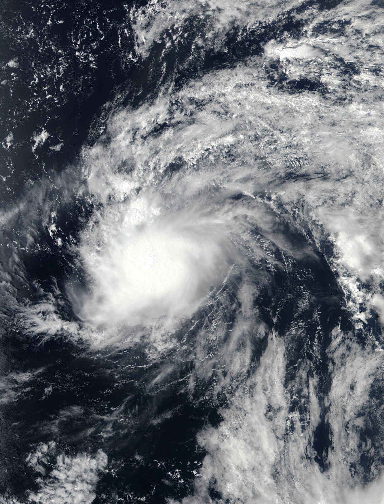
Despite forming close to the equator, the storm gained latitude steadily as its trajectory bent from west-northwest to northwest due to the influence of an upper-level low in the subtropics eating away at the ridge that usually steers such storms west. Meanwhile, Victor managed to consolidate a little and strengthen into a high-end tropical storm with maximum winds of 65 mph and a central pressure of 997 mb. However, on October 1 it moved into the sphere of influence of the aforementioned upper-level low, which began to impart strong wind shear. At the same time, Victor reached a drier airmass. The storm steadily weakened from there on out.

The storm became a tropical depression on October 2, but intermittent convective bursts allowed it to remain a tropical cyclone for a while after that. Wind shear degraded the circulation gradually and Victor at last degenerated into a trough of low pressure on October 4.


The above image shows Victor at peak intensity, when it was already dealing with increasing shear and dry air intrusion.


During most of September, the steering pattern over the tropical Atlantic allowed tropical cyclones to escape northward, out to sea. Victor followed this pattern, avoiding land areas.

Saturday, September 25, 2021

Subtropical Storm Teresa (2021)

Storm Active: September 24-25

On September 23, a surface trough formed in conjunction with an upper-level low that was producing a huge area of scattered thunderstorm activity in an arc east and south of Bermuda. The system consolidated some over the following day as it moved generally northward and a well-defined surface center appeared north of Bermuda. The island experienced only minor impacts as the disturbance passed near it. There was some deep convection too, though it was generally located north and east of the center of circulaton. The storm was non-frontal. However, it was still located under an upper-level low and furthermore did not look much like a conventional tropical storm: thus, it was classified Subtropical Storm Teresa. Teresa was the second earliest nineteenth named storm (typically, "T" storm) on record, after only Teddy of 2020.

The storm's genesis was not well-anticipated, and it only had a small window for intensification, as a powerful extratropical low was forming near New England. Teresa was heading northwest initially, and then turned north and then northeast as it became caught up in the low. Increasing shear overwhelmed the storm and it became post-tropical on September 25. The low lost its identity soon after.


Teresa's satellite presentation looks distinctly subtropical, with little convection near the center and an asymmetric appearance.


Teresa added to the list of short-lived cyclones of the 2021 season.

Wednesday, September 22, 2021

Hurricane Sam (2021)

Storm Active: September 22-October 5

A tropical wave exited Africa into the Atlantic on September 19. Finding favorable conditions, it began to organize, and a spin was soon evident on satellite imagery. It stayed pretty far south, missed Cabo Verde, and moved west over the next few days. By the 21st, a low had formed, but the disturbance didn't have the closed circulation center necessary to be called a tropical cyclone. One more day was enough for the system to become Tropical Depression Eighteen.

It took another day or so for the new tropical cyclone to start intensifying, but after that it was off to the races. On September 23, it strengthened into Tropical Storm Sam, which was the second earliest an eighteenth named storm had ever formed on record in the Atlantic (Sally of 2020 was the record-holder). Sam had a small core, which allowed it to quickly vault to hurricane strength on the 24th. There was little wind shear in the system's vicinity, and waters were plenty warm to support development; the moderately dry mid-level air around the storm was unable to penetrate it and slow down the intensification process. By the afternoon of September 25, Sam reached category 4 intensity.

After having moved west for a few days, Sam had slowed down and turned west-northwest under the influence of a weak subtropical ridge. Indeed, the ridge was so weak that Sam's forward motion was unusually slow for a hurricane in its location. The storm was still small enough that cold water upwelling didn't present a significant issue even with the lower forward speed. The cyclone had a small, symmetric eye surrounded by extremely cold cloud tops and managed to reach a peak intensity of 155 mph winds and a central pressure of 929 mb during the afternoon of September 26. Right afterward, the eye contracted and dry air forced its way into the center from the east during an eyewall replacement, causing sudden rapid weakening. This brought Sam down to category 3 by the 27th.

As the storm continued northwest, it fought back, restrengthening to category 4 the next day. Its structure was quite different, with a larger, less symmetric eye, and a larger radius of maximum winds. On September 29, it made its closest approach to the Lesser Antilles, passing well to the northeast. The next day, Sam begin to speed up and turn north as it rounded the subtropical ridge. Remarkably, the storm continued intensifying, reaching its secondary peak intensity of 150 mph winds and a central pressure of 934 mb early on October 1.

Overnight, Sam made its closest approach to Bermuda to the south-southeast; the island was far enough away to be spared significant impacts. Gradual weakening commenced as the storm recurved, but its tropical storm force windfield continued to expand. Early on October 3, Sam finally lost major hurricane strength after being category 3 or above for 7.75 consecutive days, joining only a small handful of Atlantic hurricanes to achieve this feat. Later that day, as it moved northeast toward the north wall of the Gulf stream, the eye cleared out again and became symmetric, with well-defined concentric eyewalls. This resulted in some restrengthening that evening near 40° N! The storm's structure was exceptional for that latitude. At last, on October 4, Sam encountered much colder water and began extratropical transition. As the inner core decayed, Sam weakened to a category 1. The storm became a hurricane-force extratropical low early on October 5 and merged with another low over the far north Atlantic soon after.


The above image shows Sam at its peak intensity on September 26.


Sam's long track as a major hurricane made it one of the largest Accumulated Cyclone Energy (ACE) producers recorded. Despite its longevity, Sam didn't affect any landmasses except Bermuda, to which it only delivered a glancing blow.

Monday, September 20, 2021

Tropical Storm Rose (2021)

Storm Active: September 19-23

The assembly line of tropical cyclones continued as another tropical wave began to organize in the east Atlantic around September 18. Before long, it was named Tropical Storm Rose southwest of Cabo Verde. Only 2005 and 2020 had an "R" storm (or seventeenth named storm) form earlier in the season than Rose did. At the time of its formation, the high pressure ridge usually located between Bermuda and the Azores had retreated quite far east, leaving Rose an opportunity to move north-northwest. The storm had a day or two in favorable atmospheric conditions and over fairly warm water, and it strengthened modestly.

Just north of the tropics, however, Rose found drier air, higher shear, and cooler water beginning September 21. These snuffed out the storm's thunderstorm activity, leaving it a naked swirl by the 22nd. Rose weakened to a tropical depression that day. Soon after, it degenerated into a remnant low.


The above image shows Rose over the open east Atlantic.


Due to a weakness in the subtropical ridge, Rose turned north just west of Cabo Verde and didn't spend much time at a tropical cyclone.

Saturday, September 18, 2021

Tropical Storm Peter (2021)

Storm Active: September 18-22

A tropical wave entered the Atlantic in mid-September and encountered some favorable conditions for development; already by September 15, after about a day over water, there was a well-defined center of circulation. However, thunderstorm activity was limited over the next few days as it moved west-northwest. Convection increased some as the system moved nearer to the Lesser Antillies on the 17th, but it took until the 18th for a true closed surface low to appear. At that time, it was designated Tropical Depression Sixteen. Soon after that, it strengthened into Tropical Storm Peter.

Peter was approaching a major threat to its survival: a powerful upper-atmospheric trough was bringing high wind shear to much of the western Atlantic, and conditions became hostile for the new tropical storm as it continued west-northwestward. It managed to strengthen a little more the shear out of the west stripped the center of thunderstorm coverage on September 19. Flare-ups continued over the next day though, when the center passed just north of the Leeward Islands, too far away to cause much in the way of rain.

The system followed a typical curving path toward the north after that. Relentless shear brought about Peter's steady decline starting on September 20. The next day, it weakened to a tropical depression, and the following day, a remnant low. The remnants showed some signs of organization a few days later and were briefly monitored for redevelopment south of Bermuda. However, ex-Peter did not manage to regenerate into a tropical cyclone. Soon, it was absorbed by a larger low to the north.


The above image shows the sheared Tropical Storm Peter shortly after being named.


After crossing the tropical Atlantic as a tropical wave, Peter spent only a few days as a tropical cyclone because of hostile upper-level winds.

Tropical Storm Odette (2021)

Storm Active: September 17-18

Around mid-September, there was an area of disturbed weather just northeast of the Bahamas associated with an upper-level trough. Gradually the vorticity worked down to surface level as the system moved generally north-northwestward over the following days. Shear was fairly high in the area, but the low managed to develop enough convection to be named Tropical Storm Odette off the U.S. mid-Atlantic coast on September 17.

Though it formed pretty close to land, it was already moving out to the northeast. Moreover, it was already beginning extratropical transition! The thunderstorm activity was well east of the center of circulation, and this "center" was in fact multiple low-level swirls orbiting one another. The poorly-organized cyclone degraded further as shear increased, but nevertheless strengthened due to interaction with an approaching front. Just a day after being named, Odette became post-tropical. The low moved out over the open north Atlantic and stalled southeast of Atlantic Canada for a few days. Though it was monitored for redevelopment, ex-Odette did not regenerate into a tropical cyclone. Within a few more days, it was swept away by the next trough entering the Atlantic.


The above image shows Odette shortly after formation. At least three vortices are visible, with the deep convection displaced east of the center.


Odette was only tropical for a day (see circular dots), but the post-tropical low spent several days meandering the north Atlantic after becoming post-tropical (triangular points).

Sunday, September 12, 2021

Hurricane Nicholas (2021)

Storm Active: September 12-16

During early September, another tropical wave crossed the Atlantic, this one passing through the tropics without incident until it reached the southwestern Caribbean Sea. While the wave moved over central America on September 9, the northern portion pursued a more northwestward course toward the Bay of Campeche. There it merged with a trough, producing a large area of disturbed weather. Southwesterly wind shear made development slow, but the system managed to organize enough to be designated Tropical Storm Nicholas during the morning of September 12.

Nicholas initially moved northward, but turned a little toward the right on the 13th. Though that was the storm's general trajectory, the evolution of the interior was complex. The cyclone reformed to the north and east a few distinct times that day, and at points there were multiple vortices evident on radar, rotating one another cylonically. Despite the lack of a persistent center, Nicholas deepened significantly over the warm waters of the western Gulf of Mexico and reached hurricane strength very close to the coast of Texas that night (attaining a minimum pressure of 988 mb).

Just before landfall, Nicholas turned northeast and slowed down, postponing when it crossed the coastline into the early morning hours of September 14. At the time, it had its greatest peak winds of 75 mph. The storm quickly weakened inland as it moved east-northeast. Nevertheless, it was a prolific rain producer, with storm totals exceeding a foot of rain in parts of Texas and Louisiana. That night, it weakened to a tropical depression. Nicholas lingered near the Louisiana coast for several more days, decaying gradually, but still adding to its rain totals in the south. It became post-tropical on September 16, and finally dissipated on the 17th.


The above infrared satellite imagery shows Hurricane Nicholas just before landfall in Texas very early on September 14.


Nicholas's slow forward motion over the Gulf coast elevated rainfall amounts in Louisiana.

Saturday, September 11, 2021

Tropical Storm Mindy (2021)

Storm Active: September 8-9

A broad low pressure system formed in the extreme southwestern Caribbean near the beginning of September. Due to land interaction and strong upper-level winds, it was disorganized at first as it drifted over Nicaragua and then farther northwest over the following several days. It didn't have the chance to do much more than produce scattered downpours until it cleared the Yucatan Peninsula on September 5. Even then, atmospheric conditions weren't all that favorable as it slowly turned north and then northeast over the Gulf of Mexico. When the disturbance finally did spin up, it was in a hurry. On September 8, a closed circulation suddenly developed off the coast of the Florida panhandle. The system was named Tropical Storm Mindy.

In the few hours it had over water, Mindy developed an impressive core on radar. Winds were estimated to reach 45 mph when the cyclone made landfall that night. The storm weakened to a tropical depression over southern Georgia the next morning and turned east-northeast. Though it emerged back over water by the afternoon of the 9th, conditions were not favorable for restrengthening. This was due to a nearby front and the outflow of Hurricane Larry. Mindy became post-tropical that night and dissipated entirely soon after.


The above image shows Tropical Storm Mindy just after formation and just before landfall in Florida.


Mindy was another short-lived storm which strengthened right before landfall in the U.S.

Wednesday, September 1, 2021

Hurricane Larry (2021)

Storm Active: August 31-September 11

An intense tropical wave moved westward across Africa near the end of August, splashing down off the coast of Guinea on the 30th of that month. Unlike some of its predecessors, this system organized almost immediately and was desginated Tropical Depression Twelve southeast of Cabo Verde during the evening of August 31. The storm was large, but strengthened remarkably quickly. Curved convective bands soon surrounded the center and what appeared to be a dry slot in fact was incorporated into the circulation as a proto-eye. The depression became Tropical Storm Larry and didn't stop there. Rapid intensification brought it to the verge of hurricane strength less than a day later. Early on September 2, it was upgraded to a hurricane.

After that point, it took some time for Larry's internal structure to catch up with its impressive outer bands. Over the next day, an eyewall tried to form multiple times, though none of the attempts were quite closed all the way around. Furthermore, the storm had multiple concentric eyewalls at times, complicating the strengthening process. Gradual strengthening continued nevertheless and Larry became a category 2 on September 3. A final burst brought the storm to major hurricane status overnight. From there, it remained a category 3 for several days. uring this stretch, Larry also reached its peak intensity of 125 mph winds and a minimum central pressure of 955 mb. Structural changes continued, however: around September 6, Larry became an annular hurricane. This type of hurricane has a large symmetric eye and little in the way of banding features. They are also more resilient to changes in the surrounding environment.

Indeed, the enviroment around Larry did change some. It slowed down and turned northwest during the same period, and the slower motion over led to more cold water upwelling beneath the storm as it gained latitude. Waters in the area of the subtropical Atlantic it traversed were just as warm or warmer as those it had encountered before, but the high ocean temperatures did not extend as deep, leaving Larry susceptible to churning cold water up under itself. This didn't slow it down too much though, perhaps again due to the annular structure. The storm weakened back to a category 2 only on September 8th as some dry air disrupted the center, but it was larger than ever and was producing rough surf all along the Atlantic coast of north America.

The storm turned the corner and made its closest approach to Bermuda on September 9 as a strong category 1, around 170 miles east-northeast of the island. Despite the center being far away, Bermuda still experienced some gale conditions. From there, the storm turned north-northeast and accelerated as hurricanes usually do in the mid-latitudes. On the 10th, it crossed north of the Gulf stream and encountered much colder ocean temperatures. Despite that, it only weakened a little and maintained an impressive inner core as it slammed into Newfoundland that night. By then, its forward speed was over 45 mph, so hurricane conditions arrived and departed in only a few hours. Remarkably, Larry was still tropical as it entered the Labrador sea, and remained a hurricane north of 50° N. It finally became extratropical on the 11th at a latitude of 54° N.

Soon after, it merged with another extratropical low. Larry's journey northward, along with its interaction with a mid-latitude trough, had the effect of transporting a huge amount of warm air and moisture poleward. As a result, the last impacts of ex-Larry were pretty unusual: on September 12, the combined low moved off the coast of Greenland, causing a huge snowstorm that dumped several feet of snow in areas of southeastern Greenland.


The above image shows major hurricane Larry over the open Atlantic. The lack of outer banding features and large eye are typical features of an annular hurricane.


Larry was the first tropical cyclone to strike Newfoundland as a hurricane since Igor in 2010.