Thursday, September 29, 2016

Hurricane Matthew (2016)

Storm Active: September 28-October 9

On September 22, a tropical wave exited in the African coast and moved rapidly westward across the Atlantic. For the next few days, the wave remained south of 10°N and embedded in the Intertropical Convergence Zone. Combined with the dry air over the east Atlantic, this factor precluded development initially. By the 26th, thunderstorm activity had increased and spiral bands had begun to appear on the north side of the disturbance. The system was still too far south to acquire spin, but it began to move west-northwest over the following day and acquired additional organization. By September 27, the wave was generating winds to near tropical storm force, but had not yet developed a closed circulation. Early on September 28, the system appeared on satellite imagery to be more organized, and aircraft reconnaissance confirmed the presence of a closed circulation later that day. Therefore, advisories were initiated on Tropical Storm Matthew. The aircraft also estimated that surface winds of 60 mph were already present, making the newly formed Matthew already a strong tropical storm.

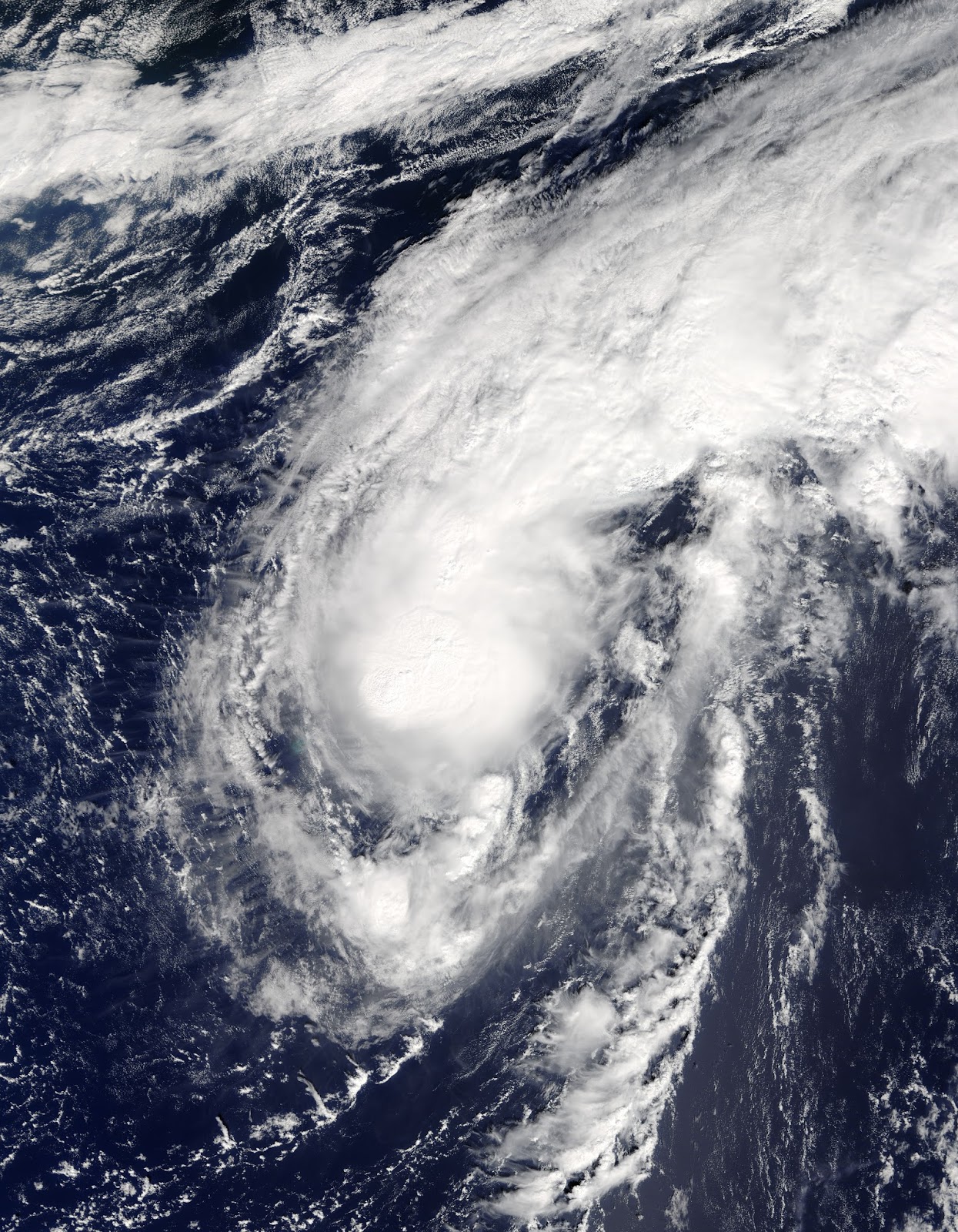
At the time of formation, Matthew was passing through the Lesser Antilles and entering the Caribbean, bringing strong storms to the region. During the morning of September 29, moderate shear out of the southwest exposed the center briefly. However, high ocean temperatures and increasing humid air near the system allowed an inner core to quickly develop. By the middle of the afternoon, Matthew had strengthened to a hurricane. Meanwhile, the cyclone veered slightly south of west. Overnight, strengthening continued, bringing Matthew to category 2 status by the morning of September 30. Conditions began to deteriorate in the northernmost areas of Columbia later that morning. It is very unusual for tropical cyclones to affect South America, but Matthew's track was quite far south through the Caribbean. Around the same time, an eye appeared on satellite imagery and further rapid intensification took place. That afternoon, the system vaulted through category 3 and up to category 4 status. During the late evening, Matthew peaked as a category 5 hurricane with winds of 160 mph and a central pressure of 941 mb, making it the first category 5 hurricane in the Atlantic since Felix in 2007. Achieving this intensity at 13.3°N latitude, it was also the southernmost category 5 hurricane ever recorded in the Atlantic.

The forward speed of the system had slowed considerably at this point, although it was still moving west or just south of west. Early on October 1, the eye shrunk and the inner core became less organized, resulting in some weakening that day. This weakening was temporary, however, for after completing a small cyclonic loop that afternoon, Matthew regained strong category 4 strength and its new lowest pressure of 940 mb. The cyclone's motion remained slow and somewhat erratic through the following day, averaging to a general northwestward track during the day of October 2. Later that day, the outer rain bands of Matthew began to affect Jamaica and Haiti as it approached from the south. The system turned to the north and experienced slight weakening that night, but still maintained category 4 intensity. Matthew's structure did not change much the next day as it steadily approached the Greater Antilles. Extremely heavy rains began over Haiti on the 3rd and continued as the storm came closer and closer. Early on October 4, the center passed well to the east of Jamaica, though the island still experienced tropical storm conditions. Meanwhile, Matthew's pressure dropped to 934 mb, though the winds remained within category 4 intensity. Around 7:00 am EDT on October 4, Matthew made landfall in southwestern Haiti with maximum winds of 145 mph, the strongest hurricane to make landfall in the country in over 50 years.

Interaction with land began to slowly weaken the system, though the inner core remained largely intact. The cyclone emerged over water a few hours later and traversed the channel between Cuba and Haiti that day. It remained a category 4 with 140 mph winds when it made landfall near the eastern tip of Cuba at 8:00 pm EDT that evening. The cyclone stalled its northward motion slightly over land and weakened more substantially, becoming a category 3 storm early on October 5. By that time, it had again emerged over water and was entering the Bahamas. An amplifying ridge to the cyclone's east caused a northwest turn later that day. Meanwhile, Matthew began to recover from its land interactions that evening, with the pressure dropping and winds increasing as the eye passed through the Bahamas. Later on October 6, Matthew peaked as a category 4 once again. Rain bands had begun to affect Florida's east coast at this point and the cyclone continued to move closer to land, turning toward the north as it did so. Overnight, the center moved roughly parallel to the central and northern Florida coastline, with the outer eyewall bringing strong winds and heavy rains to the coastline from about 30 miles offshore.

Land interaction and increasing shear also started to weaken the storm as it moved northward. By the time it passed the coast of Georgia very early on October 8, the winds had diminished to category 2 strength. Matthew continued its turn and began to move northeast parallel to the U.S. coastline before finally crossing the shore late that morning as a category 1 hurricane in central South Carolina. Though the maximum winds had decreased by this point, very high levels of moisture in the atmosphere contributed to a huge rainfall event for the Carolina coasts, with over 10 inches of rain falling over a large swath of the region. In addition, the cyclone produced a large storm surge that inundated some low-lying areas. However, by this point, the hurricane was quickly acquiring extratropical characteristics, and transition was completed early on October 9. Though the system was moving eastward away from the coast, rains continued in the Outer Banks of North Carolina through the day before tapering off. The extratropical system was absorbed by a front the next day.


Hurricane Matthew was the first category 5 hurricane in the Atlantic in 9 years. The storm killed over 1000 people, a majority of whom lived in Haiti, making it the deadliest cyclone in the Atlantic since 2005. It also caused over five billion dollars in damages and was the costliest Atlantic hurricane since Hurricane Sandy of 2012. The above image shows the cyclone at peak intensity in the Caribbean Sea.


Matthew formed and strengthened unusually far south in the Caribbean before turning sharply northward and impacting the Greater Antilles, the Bahamas, and the U.S. east coast.

Tuesday, September 20, 2016

Tropical Storm Lisa (2016)

Storm Active: September 19-24

On September 16, a tropical wave moved off of Africa into quite favorable conditions in the eastern Atlantic. As a result, an area of low pressure developed almost immediately and an impressively broad circulation developed. After initially having some trouble consolidating, the circulation became well-defined on September 19 and the system was classified Tropical Depression Thirteen. Shortly after formation, the depression took a west-northwest turn toward a weakness in the ridge to its north. Steady organization followed over the next 24 hours as the system strengthened into Tropical Storm Lisa during the morning of September 20 and then experienced more strengthening through that evening.

Due to the presence of an upper-level low pressure system located to the northwest of Lisa, shear out of the west and southwest began to increase dramatically on September 21, gradually exposing the center of circulation as convection retreated to the east. Lisa held its own, however, continuing to produce very deep convective bursts. It even rebounded from a momentary weakening that day by strengthening to its peak intensity of 50 mph winds and a pressure of 999 mb during the morning of September 22. There was evidence by this point that the circulation was becoming elongated in response to the continued shear. Meanwhile, thunderstorm activity began to wane and Lisa weakened through the rest of the day and overnight.

The storm experienced once last resurgence of thunderstorms during the morning of the 24th and in fact was upgraded back to tropical storm status as a result. However, this was only a temporary reprieve. By that afternoon, the circulation was entirely bare. Lisa was downgraded to a tropical depression that afternoon and a remnant low that night. The circulation produced shower activity for an additional few days before dissipation.


The image shows a disorganized Lisa over the eastern Atlantic.


A break in the ridge to Lisa's north allowed it to veer north quite far east and encounter hostile atmospheric conditions quite quickly.

Thursday, September 15, 2016

Tropical Storm Karl (2016)

Storm Active: September 14-25

On September 12, a tropical wave near the African coastline began to show signs of development. Beginning the next day, gusty winds and locally heavy rain began to affect the Cape Verde Islands as the disturbance moved west-northwest toward them. The system acquired a surface circulation fairly rapidly and was classified Tropical Depression Twelve on September 14, while still over the islands. Moderate wind shear out of the west kept the center exposed and prevented strengthening over the next day. Late on September 15, however, organization markedly increased and the depression intensified into Tropical Storm Karl.

The next day, thunderstorm activity was pushed a bit farther away from the center by the wind shear, and Karl lost some organization. Additionally, the system took a turn to slightly south of due west by the morning of the 17th. Slight weakening followed, though Karl remained essentially steady state through September 18. The system's direction did change toward the west-northwest, and Karl began to gain latitude. Late on September 19, it appeared that the system was finally starting to organize as shear diminished, but thunderstorm activity collapsed into disorder again the next morning. Upper-level winds had not abated as anticipated, and the Karl in fact weakened to a tropical depression late on September 20th.

The long-awaited relaxation of shear commenced the following day, and the overall structure of Karl became much more symmetric, with banding features and deep convection on all sides of the circulation. This large-scale improvement was unusually not accompanied by any development of the inner core. Rather, it remained broad, rather like a pre-tropical system. As a result, Karl remained a tropical depression through the morning of September 22, still moving northwestward over the open Atlantic. Later that day, the cyclone finally began to strengthen, regaining tropical storm strength that evening and continuing to intensify through the morning of September 23 as outflow drastically improved. The system began to round the edge of the subtropical ridge that day and turned toward the north.

Conditions worsened in Bermuda throughout the day as Karl approached, eventually escalating to tropical storm force winds and heavy rains overnight. The center turned to the northeast just short of Bermuda early on September 24 and the system began to quickly accelerate away from the island. Wind shear was high across the system, but as it was beginning to undergo extratropical transition, there was some increase in intensity that day, bringing Karl to its peak of 70 mph winds and a pressure of 990 mb that night. By the morning of September 25, the cyclone was speeding northeast at almost 50 mph and was declared extratropical.


The above image shows Karl just after passing Bermuda.


Despite existing as a tropical cyclone for 11 days, Karl was never able to intensify into a hurricane.

Wednesday, September 14, 2016

Tropical Storm Julia (2016)

Storm Active: September 13-18

On September 8, a tropical wave located east of the Lesser Antilles began to exhibit some signs of organization. However, atmospheric conditions were rather hostile, so the system moved west-northwest and then northwest for several days without significant change. On September 11 and 12, the disturbance brought some storms to the Bahamas as it passed through. Surface pressures remained high, so not development occurred during that time. That night, the circulation center of the low moved over the Florida peninsula. Despite this, the warm waters just to the east fueled a huge increase in convection just offshore and caused the system to strengthen. Late on September 13, the low was upgraded to Tropical Storm Julia even while the center was just inland over northeastern Florida. Julia was the first Atlantic storm to form over land since 1988.

After moving northward overnight and crossing inland into Georgia, the center reformed farther east on the 14th and moved over water. Though land interaction lessened, wind shear increased out of the west. This made it difficult for Julia to develop thunderstorm activity over the center and the system weakened to a tropical depression by the morning of September 15. Now moving slowly eastward, Julia put some distance between itself and the coast, ending significant rainfall over the Carolinas and Georgia and averting a potential flooding event. That night, new convective bursts including gale force winds indicated that the system was once again a tropical storm.

Over the next day, the forward motion of Julia slowed to a standstill and it lost organization as hostile conditions continued. As a result, it was again downgraded to a depression by the morning of September 17. The cyclone maintained no persistent convective features that day, but intermittent bursts were enough to maintain the cyclone as tropical. In the meantime, the center of circulation adopted a slow northwestward drift. Soon, however, dry air finally overwhelmed the system, and it was downgraded to a remnant low the evening of September 18. The low continued northwestward slowly until it merged with a front near the coast of North Carolina.


The above image shows Tropical Storm Julia shortly after formation over Florida. Most convection associated with the system remained offshore to the east.


Julia meandered near the U.S. southeast for several days before wind shear and dry air destroyed the system.

Monday, September 12, 2016

Tropical Storm Ian (2016)

Storm Active: September 12-16

Near the end of September's first week, a tropical wave developed over the central Atlantic. Soon, a low pressure center developed along the southern portion of the wave and began to produce a large area of showers and thunderstorms. Despite conditions being very favorable for development, the system organized only slowly as it moved northwestward. By late on September 11, the low was producing gale-force winds. However, it did not yet possess a well-defined center of circulation. Despite the fact that upper-level winds had increased somewhat, the low managed to organize into Tropical Storm Ian during the morning of September 12.

Convection remained confined to the northeast of the center through the remainder of that day. Meanwhile, the system turned toward the north-northwest well to the east of the Lesser Antilles. The area of tropical storm force winds did experience an expansion that evening, and maximum winds increased somewhat, but Ian's structure did not meaningfully change until the afternoon of the 13th. At that time, convection managed to cover the center for the first time. However, the cyclone began to lose tropical characteristics shortly afterward, with the circulation becoming broader and losing concentrated thunderstorm activity near the center. By the morning of September 15, it was accelerating north-northeast over the open Atlantic. Ian actually appeared more tropical later that day than it had for a couple days, with deep convection reappearing close to the circulation center. However, it was racing toward the north Atlantic by this time, briefly achieving a forward speed of over 50 mph that night. At the same time, it experienced some intensification, reaching 60 mph winds and a pressure of 994 mb by the morning of September 16. The cyclone in fact continued strengthening as it became extratropical that afternoon. It merged with another strong low over the north Atlantic shortly afterward.


The image above shows Tropical Storm Ian shortly after formation.


Ian did not affect any landmasses over its short lifetime as a tropical cyclone.