Monday, November 7, 2022

Hurricane Nicole (2022)

Storm Active: November 7-11

Around November 5, a huge area of disturbed weather developed across the eastern Caribbean and neighboring areas of the Atlantic. The system was broad and disorganized, but brought several inches of rain to Puerto Rico and Hispaniola as the strongest storms passed northward through that area over the following day. A low pressure center appeared on November 6 northwest of Puerto Rico, but it was non-tropical in nature at first. This slowly changed as scattered convection developed near the center, and the system was designated Subtropical Storm Nicole early on November 7.

At first, the cyclone moved gradually northwest, but a ridge began to build north of Nicole, turning it toward the west the next day. Meanwhile, despite periodic intrusions of dry air into the center, the storm strengthened steadily. The pressure gradient between the system and the ridge drove some intense winds north of the center; as a result, Nicole had a very large radius of gale force winds, even as the core tightened. The cyclone transitioned to a fully tropical storm on November 8. It actually turned south of west that night and approached hurricane strength as it neared the Bahamas. The storm owed its continued intensification to anomalously warm waters in the western Atlantic; these waters allowed it to reach category 1 hurricane status on November 9. By then, Nicole was close to landfall in eastern Florida. The system didn't look much like a typical hurricane, as it lacked a traditional central dense overcast, but this didn't stop it from bringing strong winds and heavy rain to much of the Florida peninsula.

The center officially moved ashore very early on November 10. In doing so, it became just the third hurricane on record to make landfall in Florida in November, and the first since Hurricane Kate in 1985. Soon after, it weakened to a tropical storm. The ridge to the storm's north moved out toward the east, allowing Nicole to begin a northward turn. It nevertheless emerged briefly over the Gulf of Mexico. It stayed very close to the west coast of Florida though, and soon moved ashore again along the Gulf coast. An approaching front picked up Nicole at that point and began to accelerate it toward the northeast. The storm weakened to a tropical depression that night, and became post-tropical over the southeast U.S. on November 11. It brought a quick hit of flooding rains to regions all along the Appalachians over the next day or so.


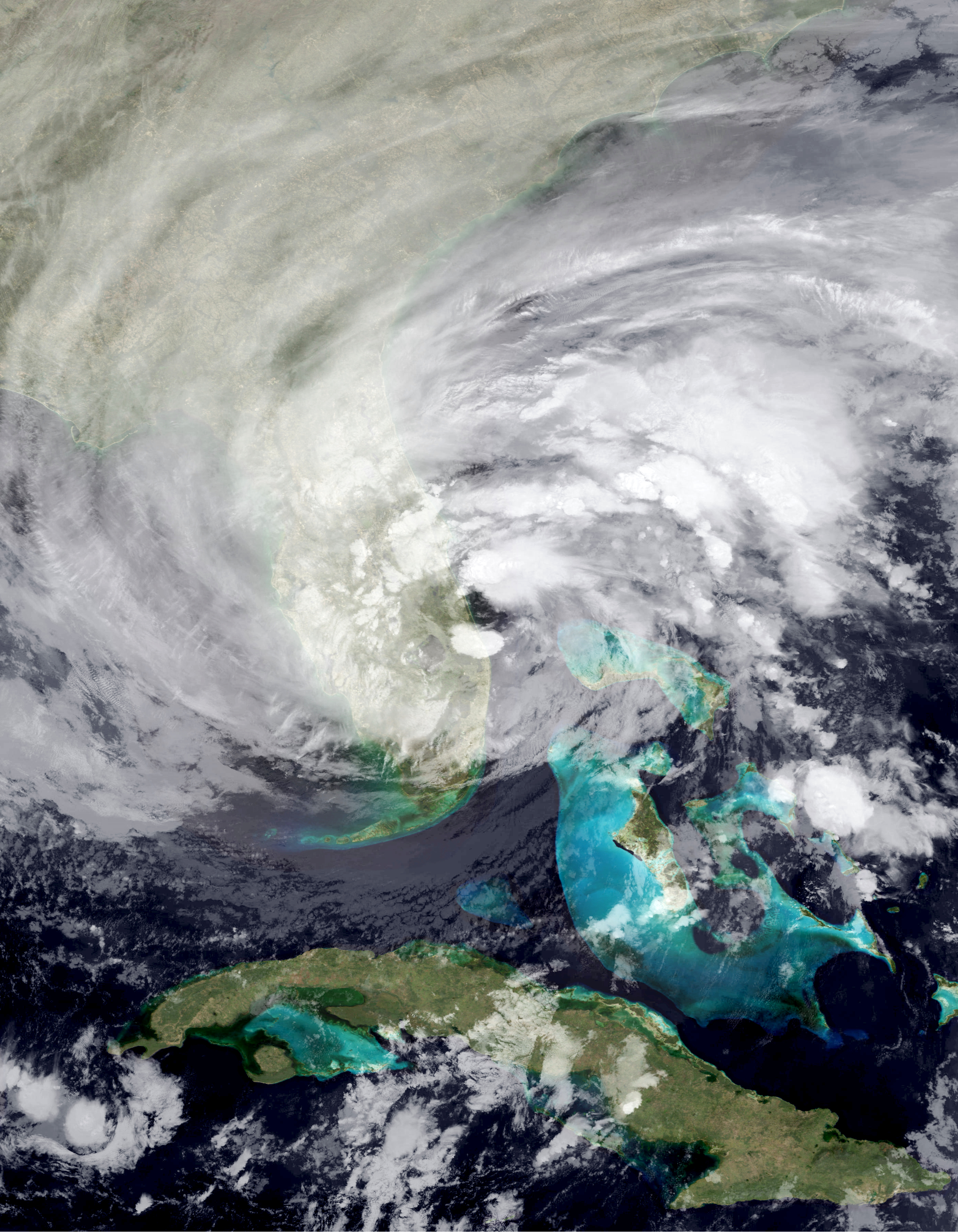
Nicole was an unusual hurricane on satellite imagery, with little convection near the center. The above image shows it at landfall on November 10.


Both Nicole's formation point and its westward track were rare for a November cyclone, allowing it to join a small handful of U.S. landfalling hurricanes in the month.

Wednesday, November 2, 2022

Hurricane Martin (2022)

Storm Active: November 1-3

On October 25, a trough of low pressure formed in the western Atlantic, extending from near the central Caribbean islands to near the U.S. East coast. The system was producing a large area of disorganized thunderstorm activity. A low formed along the trough around October 28, but it was non-tropical in nature. The system flirted with tropical status, but didn't quite have enough convective activity to be classified a tropical cyclone. The low passed near Bermuda on October 30, but strong upper-level winds prevented further development. After moving further northeastward, the system found a pocket of favorable conditions and began to strengthen and develop a warm core. On November 1, it became Tropical Storm Martin around 550 miles east-northeast of Bermuda.

The storm had a curved-band appearance on satellite imagery, with most convection extending west and north of the center. Sea surface temperatures weren't particularly warm, but a cold upper atmosphere generated enough temperature gradient for plentiful instability. In addition, a favorable jet interaction helped to drive intensification in Martin. On November 2, the storm accelerated northeastward as it felt the mid-latitude southwesterly flow, and developed a small eye on satellite imagery; as a result, Martin was upgraded to a hurricane that day. Since Martin and Lisa were hurricanes simultaneously, this became the third time in recorded history that two Atlantic hurricanes coexisted in November, after 1932 and 2001.

The cyclone intensified further on November 3, reaching peak winds of 85 mph. However, it was also swiftly becoming extratropical, with the inner core becoming less defined, but the radius of gale force winds ballooning quickly outward as the low deepened. Martin's transition to an extratropical storm on November 3 was extreme in many ways in fact: by the time it became post-tropical, it was absolutely rocketing northeastward at almost 60 mph. Tropical storm force winds extended across a diameter of over 1000 miles, stretching across a majority of the Atlantic around 50 ° N latitude. Finally, though Martin achieved a minimum pressure of 960 mb as a tropical cyclone, it deepened to a low of 932 mb after transition.

After the low's peak in strength on November 4, it began to slowly wind down and move more slowly to the east. Ex-Martin ultimately dissipated northwest of Ireland a few more days after that.


The image above shows Martin after strengthening to a hurricane on November 2.


Martin did not directly affect any land areas, but became a potent extratropical storm with hurricane force winds over the far northern Atlantic.