The word "derecho" is Spanish for "straight", and this name reflects the nature of the wind damage associated with the storms. For reasons discussed below, derechos cause "straight-line wind damage". For a thunderstorm complex to be a derecho, the complex must cause severe wind gusts (where "severe" refers to winds in excess of 50 kt or 58 mph) along a swath of land extending at least 250 miles in length.
The conditions that spawn derechos often involve the collision of moist tropical air and cool air from the polar regions, often along a cold frontal boundary. The warm, unstable nature of the tropical air causes it to rise near the border of the two air masses as the cold air slides beneath it. This process forms cumulonimbus clouds, very large clouds that can stretch from the lower atmosphere to over ten miles high. Such clouds are characteristic of thunderstorms, so storms tend to form along the frontal boundary, giving rise to a long ridge of clouds called a shelf cloud:
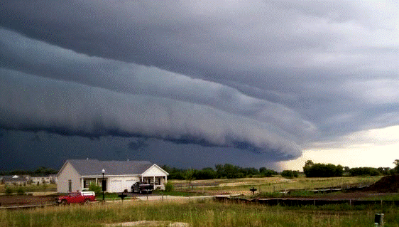 |
| A shelf cloud, representing the leading edge of a line of thunderstorms |
Another defining feature of derechos is the curvature the line of thunderstorms that develops as the system progresses. The curved radar signature left by these storms are called bow echoes, due to their likeness to archer's bows. This phenomenon is illustrated below by a composition of time-step radar images from a derecho on June 29, 2012.

Seven consecutive radar images are superimposed, showing the development of the bow echo. In addition, the image displays wind gusts observed at different locations during the progress of the derecho. Since several of these in fact were hurricane-strength gusts (exceeded 73 mph), and the storm traversed over 450 miles during its lifetime, this system does indeed meet the qualifications of a derecho.
As noted above, the hallmark of a derecho is straight-line wind damage. The sources for such winds is the downburst, a phenomenon in which cool air descends quickly to ground level and spreads in all directions, sometimes causing extremely high winds. Downbursts occur when a large air mass is rapidly cooled by the evaporation of water, the sublimation of ice directly into vapor, or the melting of ice crystals. Since all of these processes are endothermic, or require energy from the surrounding environment, they cause the air in the vicinity to cool. The mass of air, having been cooled, is now heavier than the surrounding air and accelerates toward ground level. When it reaches the ground, it is forced outward in all directions, causing winds spreading uniformly from the impact point, hence the straight-line winds.
 |
| The life cycle of a downburst |
Within a downburst, which may span distances of several tens of miles, there are sometimes smaller-scale features known as microbursts, which are a few miles in length and contain especially intense winds. On a yet smaller scale are the burst swaths that sometimes occur in microbursts, areas of just thousands of square feet in which the wind speeds may rival those of a tornado. The straight-line winds of a derecho are also responsible for the bow echoes that appear on radar. Winds emanating from near the center of the squall line fan out and cause its edges to bend into the bow shape.
Meteorologists and climatologists, using data from the past 30 years, have analyzed how often and where derechos occur, predominantly within the United States.

The above map shows the frequency of derechos in different areas of the United States. Virtually no derechos have occurred in the west, and the most active area for derechos is the southeastern plains, which periodically have multiple derechos in a single year. Note also that these storms are most common in the area stretching from Minnesota to western Ohio during the warm season, and in an area from eastern Texas through the southern Gulf states during the colder months. It is likely that derechos occur regularly outside the United States, but very few thunderstorm events have been formally classified as such.
Sources: http://spanish.about.com/od/spanishvocabulary/a/derecho.htm, http://en.wikipedia.org/wiki/Derecho, http://www.spc.noaa.gov/misc/AbtDerechos/images/HampshireIL2008July10.gif, http://www.theweatherprediction.com/habyhints/288/, http://www.xweather.org/derecho, http://www.spc.noaa.gov/misc/AbtDerechos/bowechoprot.htm, http://www.crh.noaa.gov/iwx/?n=june_29_derecho, http://www.radiotimeline.com/wx-downburst.gif, http://www.spc.noaa.gov/misc/AbtDerechos/climatologypage.htm
No comments:
Post a Comment