Thursday, September 29, 2022

Tropical Depression Eleven (2022)

Storm Active: September 28-29

Around September 21, a small tropical wave a few hundred miles west of the African coast began to produce scattered thunderstorms. Late September is near the end of "Cape Verde season", when cyclones typcially develop from tropical waves in the Atlantic between Africa and the Caribbean islands. At this tail end of the period, steering currents are typically much weaker than in late spring, so tropical waves move more slowly. This disturbance was an extreme case: it meandered around the central tropical Atlantic for a whole week, moving only very slowly the whole time. Toward the end of the week, a persistent area of convection developed, but conditions were only marginally favorable and it took a long time to acquire the organization necessary to be a tropical cyclone. At last, on September 28, it became Tropical Depression Eleven.

Shortly after formation, Eleven managed to start moving a little faster toward the north toward an upper-level trough. Proximity to this trough would be its undoing, however, for wind shear increased the further north it went. After little over a day of being a tropical cyclone, the depression had its thunderstorm activity stripped away toward the northeast by the strong shear and it became a remnant low. This low dissipated very soon after that.


Tropical Depression Eleven was a small and short-lived storm, which did not encounter conditions favorable enough for it to strengthen.


Eleven's slow meandering track as a distrubance and brief tenure as a tropical cyclone did not take it near any land areas.

Saturday, September 24, 2022

Tropical Storm Hermine (2022)

Storm Active: September 23-25

A powerful tropical wave located over Senegal in west Africa entered the Atlantic on September 22 and immediately began to organize. It became Tropical Depression Ten the very next day. Very unusually, it moved north-northwest after hitting the ocean, responding to a weakness in the ridge to its north. That night, it strengthened into Tropical Storm Hermine, stealing the "H" name from Tropical Depression Nine, which only became a tropical storm a little later and therefore was assigned the name Ian.

Hermine managed to produce deep convection to the north-northeast of the center through early on the 24th, but as it moved north conditions turned hostile quickly. Cool ocean waters and strong upper-level winds stripped the center of thunderstorm activity by the afternoon. Since these winds pushed the moisture associated with Hermine northeast, the storm indirectly brought scattered heavy rains to Mauritania, Western Sahara, and the Canary Islands. These regions have a desert climate and it was very rare for them to be affected, even indirectly, by a tropical cyclone. Hermine weakened to a depression that evening. The next day, the shallow system turned back toward the west and became post-tropical. Its remnants dissipated shortly therafter.


The above image shows Hermine just after formation on September 23. The western coast of Africa is visible at right.


Hermine took an unusual northward path in the far eastern Atlantic and brought precipitation to northwest Africa and the Canary Islands, which are visible above and to the right of the storm track.

Hurricane Ian (2022)

Storm Active: September 23-30

A tropical wave moved over the Atlantic around the middle of September. It took a quite southerly track and had little in the way of organized thunderstorm activity before reaching the Caribbean on September 21. Though Caribbean waters were warm, strong upper-level winds from the outflow of the enormous Hurricane Fiona hindered the system from consolidating. Despite this, a well-defined surface low formed on the 22nd. At first, there wasn't enough convection near it to classify as a tropical cyclone, but it became Tropical Depression Nine early on September 23. Only late that day when Fiona was approaching Canada did the associated upper-level winds finally die down enough for the depression to strengthen more easily. It was named Tropical Storm Ian that night. The "I" name was assigned to this storm because in between being named a tropical depression and a tropical storm, a new depression (Ten) formed and took the name Hermine.

Wind shear had diminished, but Ian had internal structural issues to overcome. The low- and mid-level circulations were not vertically stacked, preventing organization for a day or so. Meanwhile, the storm moved westward, passing well south of Jamaica. After the vortices had become better aligned on September 25, the system still had trouble developing deep convection due to dry air inside in the circulation. Ultimately, the favorable conditions of the western Caribbean allowed Ian to overcome this obstacle as well and begin rapid intensification.

This trend brought the storm to hurricane strength by early on September 26 as it gradually curved toward the north. Ian managed to reach category 2 by that night without having a complete eyewall; rather, the core still consisted of spiral bands. Another burst of intensification occurred just before landfall in western Cuba overnight. At landfall, it had maximum winds of 125 mph (category 3 intensity) and a minimum central pressure of 947 mb. The storm's passage northward over land did weaken it, but the inner structure actually improved, if anything. When the center emerged over the Gulf of Mexico during the morning of the 27th, it almost immediately cleared out a large eye. By this time, Ian was feeling the influence of a potent trough of low pressure over the eastern United States and turned very gradually east of north in its southwesterly flow.

The hurricane underwent an eyewall replacement cycle that afternoon. In this process, a secondary eyewall forms outside the first, ultimately contracting and replacing it. Ian's maximum strength did not increase during this process, but its radius of tropical storm and hurricane-force winds increased. A new, larger eye began to emerge that evening. Soon, the hurricane was intensifying again and became a category 4. This trend unforunately continued almost until landfall. Ian ultimately reached a peak strength as a category 5 hurricane with 160 mph winds and a central pressure of 937 mb during the morning of September 28. (Note: Ian was upgraded to a category 5 in post-season analysis; operationally, it was considered a 155 mph category 4 at the time of peak intensity.) A few hours later, the storm made landfall along the western coast of Florida at only the slightly reduced intensity of 150 mph winds and a pressure of 940 mb.

The imapcts to the landfall region were devastating; the slow-moving storm brought significant storm surge just south of the landfall point and extreme rainfall totals generally north of the center. Ian moved northeast across the state for the next day or so and weakened down to a tropical storm before emerging into the Atlantic ocean early on the 29th. By that time, the cyclone was no longer fully tropical; its interaction with a trough had lent it some frontal features. The windfield was large and less concentrated at the center, and similarly for rainfall. Nevertheless, access to the energy of the Gulf stream did help Ian to regain some strength and it became a hurricane again later that day.

Ian made its final landfall in South Carolina during the afternoon of September 30 as a category 1 hurricane with peak winds of 85 mph and a central pressure of 977 mb. Shortly after landfall, the storm lost what remained of its warm core and transitioned to a post-tropical system. The remnants weakened rapidly and merged with another disturbance over the mid-Atlantic the next day. The moisture from Ian contributed to a prolonged rain event for the coastal northeastern United States over the following several days.


The above image shows Ian at peak intensity a few hours before landfall in Florida.


During the latter part of Ian's track, it consistently deviated to the east of most forecasts due to the difficulty of predicting its interaction with a trough over the eastern United States.

Tuesday, September 20, 2022

Tropical Storm Gaston (2022)

Storm Active: September 20-25

On September 15, a tropical wave entered the Atlantic ocean. Some disorganized thunderstorm activity developed near the northern end of the tropical wave over the next couple of days. A weakness in the Azores high pressure allowed the disturbance to lift northward, though this brought it into generally less favorable conditions for cyclone development. Around September 19, a weak low formed in association with the system; rather unexpectedly, it became Tropical Depression Eight the next day. Finding a window of light wind shear and an unstable atmosphere, it began to intensify and became Tropical Storm Gaston by the evening.

Gaston was not completely tropical; it derived some of its energy from baroclinic processes, which allowed it to intensify in a rather unfriendly environment. On the 21st, it became a strong tropical storm. It had moved north-northeast since formation, but turned more toward the east the next day, following a clockwise path around the northern edge of the Azores high. Speaking of the Azores, the system was approaching the westernmost islands by that evening. Gaston was a relatively small storm and was beginning to lose its inner core by that point, but it still brought scattered heavy rains to the Azores beginning late on September 22.

The center in fact veered south and moved very close to the islands the next day. Gaston even underwent an bit of unexpected strengthening and reached its peak intensity of 65 mph winds and a central pressure of 995 mb that afternoon. Soon after, upper level winds and more stable air quelled convective activity and caused the system to weaken. The storm continued its clockwise path, turning back toward the west on September 24. Though a few bursts of thunderstorms halted weakening temporarily, the general degradation of Gaston continued until it became post-tropical on September 25.


The above image shows Gaston approaching the Azores on September 23.


Gaston took a meandering track across the subtropical Atlantic away from any land besides the western islands of the Azores.

Wednesday, September 14, 2022

Hurricane Fiona (2022)

Storm Active: September 14-23

On September 7, a tropical wave emerged off the coast of Africa. It moved steadily west-northwestward over the next several days, but didn't organize too much due to marginal conditions: dry air was still unusally prevalent across the Atlantic basin. Nevertheless, the system ultimately prevailed over its surroundings and became Tropical Depression Seven on September 14. The new depression's center was on the western edge of the main convective mass, but that associated thunderstorm activity was quite vigorous. By later in the day, the system was generating gale force winds and strengthened into Tropical Storm Fiona.

The storm moved due west over the next couple of days and managed to intensify some, even though the center of circulation was consistently outrunning any associated thunderstorm activity. As Fiona's rainbands chased its naked low-cloud swirl westward, the storm began to affect the Lesser Antilles on September 16, bringing a slew of heavy rain to the islands. After entering the northeast Caribbean sea, the system slowed down and the large-scale circulation improved in symmetry. However, Fiona was still ingesting dry air on the 17th. As a result, it was difficult for the tropical storm to develop a central dense overcast, a prerequisite to further strengthening. The system also began to feel a weakness in the subtropical ridge and turned north of west by that evening.

Suddenly, on Sptember 18, Fiona got its act together and started to organize quickly, probably due to higher ocean heat content and moister air in the Caribbean. Late that morning, it strengthened into a hurricane. By that point, the center was approaching the southern coast of Puerto Rico. Rain had already begun on the island, but an exceptional rain event began that afternoon when Fiona's burgeoning eyewall pushed ashore. The center of circulation made landfall in extreme southwest Puerto Rico a few hours after that, but had soon moved northwestward over water again in the Mona Passage.

That night, the storm made a second landfall near the eastern tip of the Dominican Republic as a high-end category 1 hurricane, becoming the first hurricane to make direct landfall in that nation since Hurricane Jeanne in 2004. Fiona passed over only relatively low-lying land areas, so land interaction scarcely hampered the hurricane. Early on the 19th, it emerged off the northern coast and began to strengthen again. An eye became evident on satellite imagery that day and Fiona was upgraded to a category 2. By that time, the rain event had finally concluded in Puerto Rico and most of the Dominican Republic, where over 25 inches of rain were recorded in certain areas.

The far eastern Bahamas also had a close brush with the storm early on September 20 as it turned north-northwestward and passed just to the east of the islands. Though the Bahamas experienced the less intense western semicircle of the storm, hurricane conditions still affected those regions for a few hours. Around the same time, Fiona intensified into the first major hurricane of the 2022 season. The storm moved away from the Bahamas and strengthened further over the next day. Even more pronounced was its increase in size; much of Fiona's decreasing pressure contributed to an expansion of its wind radius through a series of frequent eyewall replacement cycles. Early on September 21, the system reached category 4 status.

The hurricane turned north-norhteast and accelerated that day as it began to feel the influence of a powerful trough over eastern North America. On the 22nd, gale conditions enveloped Bermuda as Fiona approached. That night, the storm reached its peak intensity as a tropical cyclone of 130 mph winds and a minimum central pressure of 932 mb. Fortunately, the hurricane passed well west of Bermuda, preventing it from feeling the worst impacts. The same could not be said for Atlantic Canada: by early on the 23rd, the system was turning back north toward Nova Scotia. The front approaching Fiona began to interact and merge with the hurricane, making the circulation more asymmetric and beginning extratropical transition. Maximum winds dropped but the storm's barometric pressure remained extremely low as it transitioned that day.

When night fell, Fiona was rocketing northward at over 40 mph. It officially became post-tropical late in the evening but this did not mitigate impacts much when it slammed into eastern Nova Scotia in the early morning hours of September 23. Tropical storm force winds affected an extremely large area from eastern Maine to Newfoundland. Hart Island, Nova Scotia recorded a central pressure of 931.6 mb in Fiona; in terms of pressure, the storm's peak intensity likely occurred just after post-tropical transition. Not only that, but this pressure reading was the lowest ever recorded in Canada from any storm in history, crushing the previous mark of 940.2 mb set in a winter storm on January 20, 1977 in Newfoundland. The damage from wind and storm surge was severe in much of Maritime Canada.

After landfall, ex-Fiona slowed down and weakened, eventually moving over Labrador on September 24. The post-tropical storm continued to bring strong winds to Canada as it slowly spun down over the next several days.


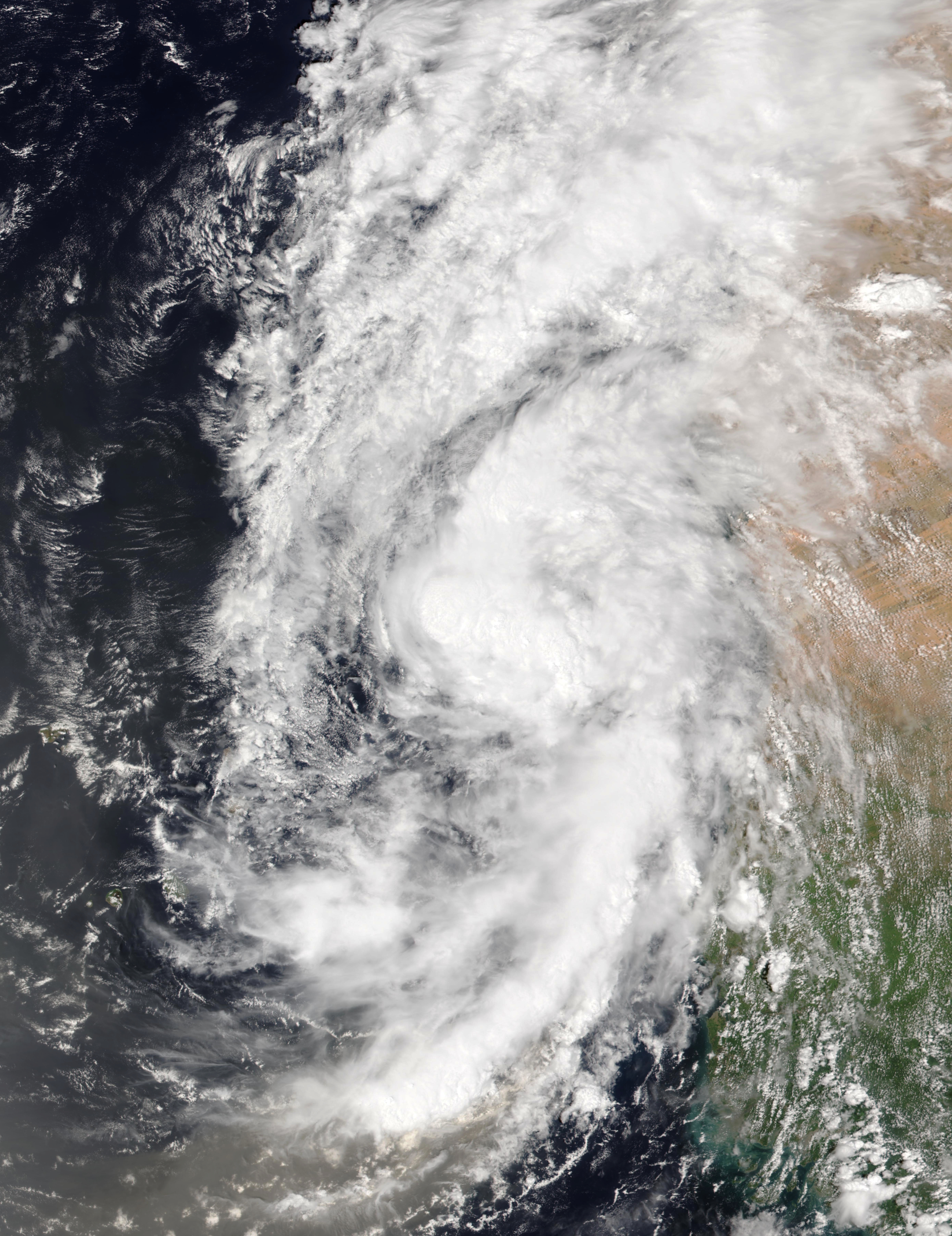
The above image shows Fiona undergoing an eyewall replacement cycle on September 21. At the time it was located over the open Atlantic between the Bahamas and Bermuda.


Extremely warm waters and a trough interaction allowed Fiona to remain an extremely intense cyclone upon landfall in Nova Scotia.

Monday, September 5, 2022

A Pacific Hurricane Update: Hurricane Kay (2022)

Though I usually only post on Atlantic tropical cyclones, this post will describe a significant eastern Pacific tropical cyclone, Hurricane Kay.

Storm Active: September 4-9

Around September 1, a disturbance formed in the Gulf of Tehuantepec, off the Pacific coast of southeastern Mexico. The atmosphere in the region was extremely humid and ocean waters were warm, giving the system ample fuel for developement. There was some wind shear present and the disturbance was very large, so it consolidated only slowly over the next few days as it moved generally westward. Satellite imagery indicated that it developed into Tropical Depression Twleve-E around midday on September 4.

It didn't take long for the depression to strengthen into Tropical Storm Kay. Kay had quite a large radius of maximum winds and an impressive satellite signature on the southern side, with curved bands extending hundreds of miles to the south and west. However, the center of circulation was nearly exposed from under cloud cover on the northern side. The storm experienced slow and steady intensification for the next day. By September 5, Kay had managed to wrap convection nearly around its center and a partial eyewall was complete. This lead to a faster increase in winds and the storm was upgraded to a hurricane that afternoon.

Kay gradually turned toward the north over the next day. Even though the center was far from land, southern Baja California experienced intermittent gale conditions from the storm's outer bands. Later on the 6th, the cyclone developed a distinct eye. Kay reached its peak intensity of 105 mph winds and a central pressure of 967 mb early on September 7, just in time for it to encounter cooler waters. This led to a slow diminishing of deep convection near the center, and consummerate drop in winds. Nonetheless, Kay remained a formidable storm as it moved closer to the central Baja California peninsula.

By early on September 8, most thunderstorm activity south and west of the center had died off over cold water. In fact, the heaviest rain associated with Kay was in bands stretching northwestward from the Gulf of California, where the water was much warmer than on the Pacific side and supported stronger storm activity. The system was still a minimal hurricane when it made landfall midway up the peninsula that afternoon. The center of Kay moved north-northwest generally parallel to Baja California's coastline and emerged over water again as a tropical storm. By September 9, the core of the storm was just a swirl of clouds, with flooding rains continuing farther north in far northwestern Mexico and southern California. It turned west under the influence of a ridge sitting over the southwestern United States as it weakened. Later that day, it was classified as post-tropical. The remnants of Kay slowly spun down and the moisture it carried northward brought additional showers to southern California over the next couple of days. Kay was one of only a few cyclones on record to directly affect California.


The image above shows Kay at peak intensity on September 7.


Kay brought beneficial rain to Baja California, southwestern Mexico, and southern California without bringing impacts that are too severe.

Saturday, September 3, 2022

Hurricane Earl (2022)

Storm Active: September 2-10

On August 25, a tropical wave entered the Atlantic ocean. It produced some thunderstorm activity over the next several days as it crossed the tropical Atlantic, but was struggling enough with wind shear and dry air that it didn't manage to organize through the end of the month. The wave turned west-northwestward as it approached the northeastern-most Caribbean islands on September 1. Conditions were still only marginally favorable, but the system managed to develop into Tropical Storm Earl late on September 2.

Around that time, Earl was making its closest approach to the Leeward Islands. Most of the gale force winds were displaced to the north and east of the center, so the islands only recieved scattered downpours from the passing tropical storm. The center of circulation outran the deep convection a little the next day, a sign of continuing wind shear. On the 3rd, the storm passed north of the Virgin Islands and strengthened modestly, but remained fairly disorganized.

The steering currents in the atmosphere around Earl were not very strong. Though the storm was gradually turning north toward a break in the low-level ridge to its north, it did so only very slowly, so occasional heavy rain persisted for a while in the northeast Caribbean, particularly Puerto Rico. The storm was still sheared, but the direction of shear changed by late on September 4 to more closely align with the storm's motion. That pattern is a little more conducive for strengthening, so the resilient Earl continued its slow intensification. The cyclone took on a comma shape, with a long tail of thunderstorms extending south and west of the core. It at last made some progress away from the islands on September 5 and very deep convection began to blossom near the center of circulation.

By the 6th, the storm was moving due north at a sluggish pace. It underwent some more structural change, with hints of an eyewall developing. Earl wasn't the most symmetric storm on satellite, but it managed a remarkable feat of continually strengthening in spite of shear and became a hurricane that day.

The wind shear began a slow decline at last on September 7, allowing the hurricane to gain strength a little more quickly, since it remained over warm water with an ample supply of moisture. That evening, Earl became a category 2. Hurricane hunter aircraft sampling winds in the system over the next day found lower maximum winds than otherwise might have been expected given Earl's appearance on satellite. As a result, the intensity was adjusted down to category 1. However, the storm's central pressure was relatively low, which was consistent with the observed large radius of tropical storm force and hurricane force winds. Earl only expanded further as it gained latitude.

The cyclone made its closest approach to Bermuda from the southeast in the early morning hours of September 9, bringing gale conditions. By that time, the storm was moving north-northeast.

Despite some disruptions to its circulation, Earl made another comeback later that day, regaining category 2 status and reaching its peak intensity of 105 mph winds and a pressure of 954 mb. The storm also briefly had a large eye. It wasn't long though before extratropical transition began, since Earl was encountering colder water off the coast of Atlantic Canada. Before becoming post-tropical, the storm ballooned to a huge size, with an estimated diameter of tropical storm force winds of over 750 miles. At last, the cyclone became post-tropical on September 10. What was left of Earl slowed down and meandered east of Newfoundland for the next several days as it steadily weakened.


The above image shows Earl on September 10 before extatropical transition. Nova Scotia and Newfoundland are visible at top left.


Earl's track was standard fare for a Cape Verde hurricane, but it did reach peak intensity unusually far north.

Friday, September 2, 2022

Hurricane Danielle (2022)

Storm Active: September 1-8

Near the end of August, a low pressure center formed along a decaying frontal boundary over the subtropical Atlantic ocean. Due to very warm ocean waters for that latitude, the disturbance was able to quickly consolidate into Tropical Depression Five on September 1 (the number "Four" had been given to a potential tropical cyclone in the Gulf of Mexico a few weeks prior, though that system never attained tropical cyclone status). Shortly afterward, the depression strengthened into Tropical Storm Danielle. The formation of Danielle ended an incredible drought of cyclone formation in the Atlantic that had reigned since July 3. 2022 was the first year since 1997 that no named storm developed in the Atlantic during the month of August.

Danielle formed around 38 ° N. Storms at that latitude tend to quickly exit northeast and become extratropical, but an unusual blocking high pressure was keeping the system almost in place. As a result, the storm scarcely moved at all over the next few days. In contrast, Danielle was changing quickly in strength. It had a compact circulation with a ring of deep convection about the center, all favorable factors for rapid intensification. By midday on September 2, the storm had already reached category 1 hurricane strength, becoming the first hurricane of the season.

The next day, some dry air from the north invaded Danielle's circulation. This disrupted the eyewall and temporarily weakened the cyclone back to a tropical storm. Eventually, the storm overcame this intrusion and restrengthened to a hurricane late on September 3. Even through the morning of September 4, the storm had hardly moved at all from where it formed. Danielle finally began to budge northward only that evening as it moved toward a weakness in the ridge to its north. Meanwhile, the storm was able to strengthen a little further to its peak intensity of 90 mph winds and a central pressure of 975 mb (a high-end category 1).

The hurricane encountered cooler water as it began to pick up speed and turn toward the northeast. As a result, some of the thunderstorm activity of the inner core collapsed on the 5th, beginning a trend of gradual weakening. Nevertheless, Danielle's satellite presentation remained impressive, with a large eye surrounded for the most part by deep convection. The next day, the storm continued northeast in the mid-latitude westerly flow and an approaching trough increased wind shear in the vicinity. It remained a hurricane through September 7.

By September 8, Danielle had little central convection left. It was downgraded to a tropical storm and became post-tropical right after. The remnants of Danielle executed a counterclockwise loop and then rocketed east. After a few more days, the weakening remnants dissipated near the coast of Portugal.


The above image shows Danielle as a hurricane over the open northern Atlantic on September 5.


Danielle was nearly stationary for its first few days as a tropical cyclone, but climatology ultimately took over and it exited northeast out to sea.