On October 3, a late season tropical wave entered the Atlantic basin. It moved quickly toward the west-northwest and steadily organized. By October 6, the wave had a very impressive satellite signature, featuring a broad area of spin and concentrated thunderstorm activity. The next day, it was named Tropical Storm Jerry. Jerry was still over a thousand miles east of the Lesser Antilles, but was moving quickly toward the west-northwest. Despite a strong start, the storm actually became less organized after it was named. By the next day, shear opposite to its forward motion had displaced all thunderstorm activity east-southeast of the center. Nevertheless, it managed to strengthen some through the evening of October 8.
Jerry approached the Leeward Islands the next day. The center made its closest approach to land during the evening of the 9th, but the accompanying rains peaked over the islands only overnight and into the next morning, since convection was so removed from the center. The storm wasn't strong, but did cause widespread flooding for the northeasternmost Caribbean islands. Only on the 10th did Jerry lift north away from the Leewards. The cyclone's center was very poorly defined, with a pronounced elongation in the northwest-southeast direction. The cyclone was never able to recover from this poor organization and lost its circulation on October 11, degenerating into a trough of low pressure.

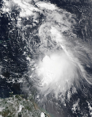
The image above shows Jerry just east of the Leeward Islands on October 9. The center of circulation ultimately missed the islands, but Jerry's passage dragged an area of heavy rain, displaced south and east of the center, across those areas over the following day.
Jerry dissipated shortly after its brush of the Caribbean.

No comments:
Post a Comment