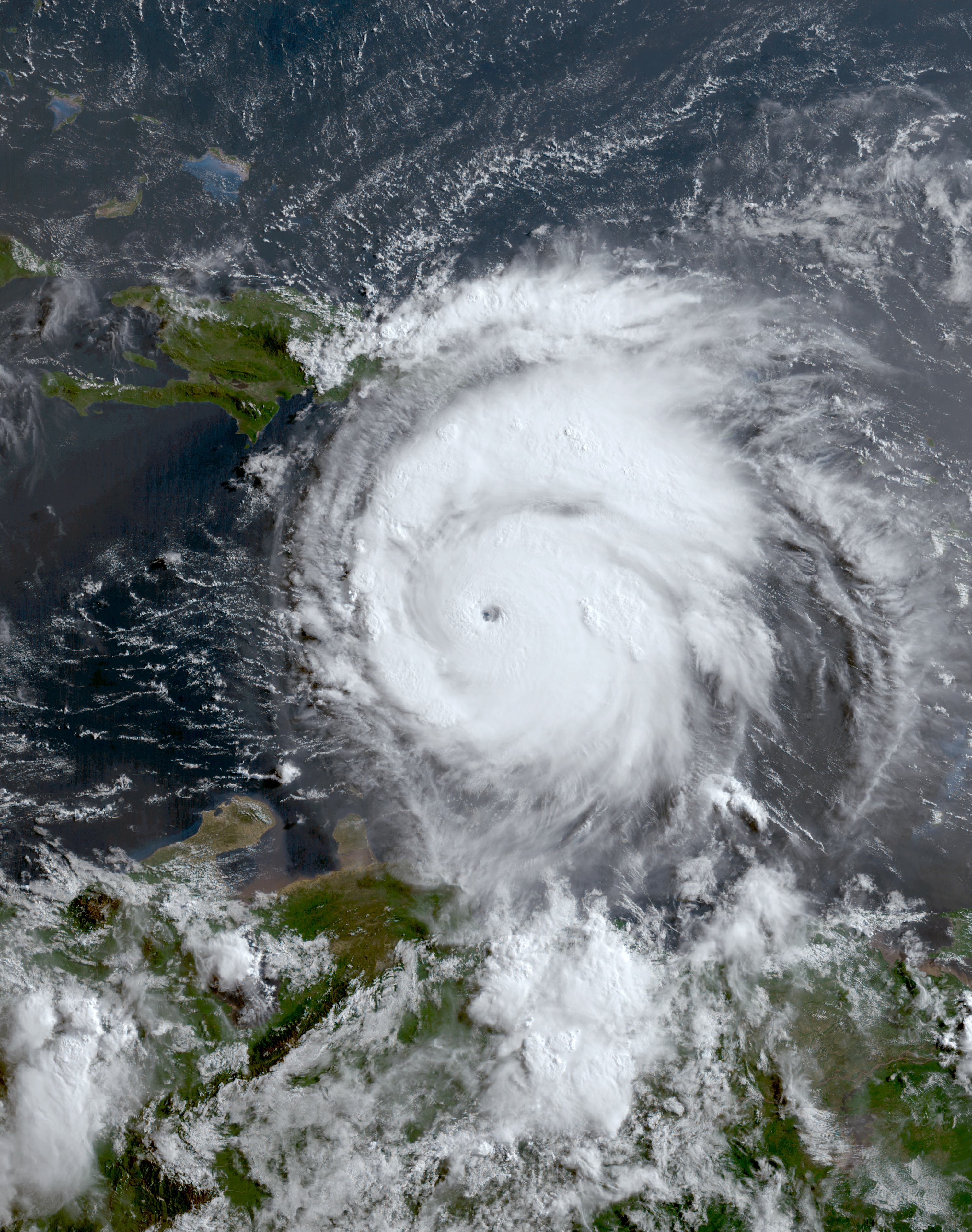
Friday, September 27, 2024

Tropical Storm Joyce (2024)

Storm Active: September 27-30

On September 22, another tropical wave left Africa and entered the eastern tropical Atlantic. Within a few days, the disturbance was close to tropical storm status, but the center was not well-defined enough. It took a few more days for the system to clear the final hurdle and become Tropical Storm Joyce on September 27, when it was located around halfway between Africa and the Leeward Islands. Joyce intensified modestly in the day after its formation and turned northwest into a weakness in the subtropical ridge. However, the system soon encountered increasing wind shear and began to weaken by September 29.

Late that same day, it weakened to a tropical depression. Though the storm continued to produce bursts of thunderstorm activity, the center became less and less defined and eventually dissipated late on September 30.


Joyce was a small tropical storm; the image above shows a satellite image from September 27.


Joyce was a short-lived tropical storm that did not affect any land areas.

Hurricane Isaac (2024)

Storm Active: September 25-30

Around September 20, a frontal boundary moved into eastward into the Atlantic ocean from North America. A well-defined non-tropical low formed along the boundary and passed north of Bermuda on September 23. Deep convection increased near the center over the next couple of days and the circulation separated from the front. The system was named Tropical Storm Isaac late on September 25 over the central tropical Atlantic.

Isaac rode the clockwise flow east-northeast around the north side of the subtropical ridge and encountered enough upper-level divergence and instability to support strengthening even over marginally warm sea surface temperatures. The storm reached hurricane status early on the 27th and an eye began to intermittently appear on satellite imagery.

Surprisingly, Isaac had a few more tricks up its sleeve, and intensified even further overnight. The eye became better defined and the surrounding area of convection larger and deeper. The storm peaked at category 2 strength on September 28 with peak winds of 105 mph and a central pressure of 968 mb. It turned northeast and began to pass over markedly colder water soon after. This began a period of gradual weakening, which brought Isaac back down to tropical storm strength by the evening of September 29, when it was passing northwest of the Azores. Beyond rough seas, there was no direct impact to the islands. Cold water and increasing shear brought about Isaac's transition to a post-tropical cyclone on September 30. The remnants continued northeastward until they dissipated west of Ireland.


The image above shows Isaac as a category 2 hurricane.


Isaac was impressively strong for its latitude, but did not affect any land areas.

Tuesday, September 24, 2024

Hurricane Helene (2024)

Storm Active: September 24-27

A large area of low pressure developed just east of central American around September 22. The sprawling system drifted generally northward, but the counterclockwise flow brought extreme rains especially to the Pacific coasts of Nicaragua, Honduras, and El Salvador. The next day, the disturbance began to organize over the eastern Caribbean, but lacked a defined center. On the 24th, it became organized enough to be named Tropical Storm Helene.

When Helene formed, its center was exposed to the west of the main convective mass due to some shear out of the southwest. However, this shear was already diminishing; high oceanic heat content and atmospheric humidity soon put the storm on a strengthening trend as it moved northwestward. Helene was a large storm, with gale force radii above the 90th percentile of historical Atlantic cyclones at the same latitude. As a result, the core was slow to consolidate, but impacts were very widespread. When the storm passed just west of the northeast tip of the Yucatan Peninsula during the morning of September 25, tropical storm force winds already extended more than 250 miles from the center in some directions. Around the same time, Helene strengthened into a hurricane.

The hurricane began to feel the flow ahead of a trough over the central United States later that day and accelerated toward the north, entering the Gulf of Mexico. Overnight, the core of Helene steadily became better defined and an eye began to emerge. Once the eyewall was well-established, the intensification accelerated on September 26. The storm reached category 2 that morning and became a major hurricane that afternoon. By the early evening, Helene's forward speed had increased to more than 20 mph toward the north-northeast and it was closing in quickly on the Gulf coast. It reached category 4 soon after, reaching a peak intensity of 140 mph winds and a central pressure of 938 mb at landfall in the big bend region of Florida late on September 26, local time.

The large size and fast motion of the storm meant that the storm surge impacts to the concave area of coastline were very severe. On top of that, hurricane-force winds spread far inland and into Georgia before the storm could spin down significantly. The wind damage was severe for a large swath of the southeast, especially just east of the center's path. Helene weakened to a tropical storm over central Georgia and only lost tropical storm status over Tennessee during the afternoon of the 27th; the cyclone became post-tropical that evening. Its remnants slowed to a standstill near the Tennessee valley and slowly diminished, but the combination of Helene-influenced rains before the arrival of the storm and ex-Helene stalling over the area led to some of the storm's heaviest rainfall amounts in the region, especially western North Carolina. What was left of the hurricane finally dissipated by early on September 29.


The image above is a nighttime infrared satellite view of Hurricane Helene at peak intensity as a category 4 hurricane just before its landfall in Florida. The storm's uncommonly large windfield caused widespread damage.


Helene was a relatively short-lived but large and devastating storm.

Wednesday, September 11, 2024

Tropical Storm Gordon (2024)

Storm Active: September 11-17

A disturbance over the eastern Atlantic crossed the Cabo Verde Islands around September 10, bringing scattered rains to the islands. The next day, the system developed a closed circulation and was classified Tropical Depression Seven. The cyclone was small, with little in the way of thunderstorm activity, and organized only slowly as it moved steadily west-northwest. It wasn't until early on September 13 that it strengthened into Tropical Storm Gordon. Convection had increased with the storm, but was slightly displaced from the center by moderate wind shear out of the west. As a result, the cyclone did not manage to strengthen much, and reached peak winds of 45 mph on September 14.

Gordon entered a drier air mass shortly thereafter and began weakening again as it slowed down and turned slightly south of west under the influence of a ridge of high pressure. It became a tropical depression on September 15. Though weakening temporarily halted that evening, Gordon was never able to fully recover. Thunderstorm activity became more and more diffuse, and the center became less defined until it dissipated altogether on September 17.


The image above shows Gordon just after it was named.


Gordon was stifled by wind shear and dry air as it crossed the central tropical Atlantic.

Monday, September 9, 2024

Hurricane Francine (2024)

Storm Active: September 9-13

A tropical wave crossed the Atlantic Ocean during the last week of August without developing significantly. It made its way across the Caribbean and the Yucatan Peninsula before finally showing signs of organization in the Bay of Campeche a week into September. When the disturbance first entered the bay on the 7th, it was interacting with a cold front, and the area of low pressure was poorly defined. The system was producing vigorous storm activity though, and by the next day was also generating sustained winds to gale force. The inner structure of the disturbance improved markedly during the morning of September 9 and it was named Tropical Storm Francine.

The storm moved slowly northwest that day around the periphery of a ridge centered over Cuba. It took advantage of the warm waters of the Gulf of Mexico and began to strengthen. That night, an intrusion of dry air caused the core convection to collapse and temporarily hindered intensification. Deepening resumed the next morning and Francine turned toward the northeast as it began to feel the approach of a trough from the northwest. The evening of the 10th, the storm was upgraded to a category 1 hurricane. The storm accelerated toward the northeast overnight and wind shear began to increase as the storm neared the Louisiana coastline. As a result, the core took on a somewhat lopsided appearance. Nevertheless, Francine reached a peak category 2 intensity of 100 mph winds and a central pressure of 972 mb that afternoon just before landfall in central Louisiana.

Once inland, the storm rapidly weakened. It weakened to a tropical depression on September 12 over Mississippi and became post-tropical that afternoon. After that, the remnants slowed down and moved erratically across the interior southeast. This brought a sustained period of heavy rain to the region, especially northern Mississippi, until dissipation occurred a few days after.


The image above shows Francine just before landfall.


Francine's impacts were mitigated by the fact that it made landfall in a sparsely populated region and weakened quickly after landfall.

Monday, August 12, 2024

Hurricane Ernesto (2024)

Storm Active: August 12-20

During the second week of August, a tropical wave traversed the tropical Atlantic. Dry air near the wave limited its shower activity, so not much development occurred at first. Some spin became evident on satellite imagery around August 11, but convection remained very limited until the next day. During the afternoon of August 12, the system acquired a well-defined center and was designated Tropical Storm Ernesto a few hundred miles east of the Leeward Islands. Newly-formed Ernesto was moving at an extremely fast forward speed of 28 mph. On that heading, it quickly approached the Caribbean and the center passed near the island of Guadeloupe early on August 13.

Considering the struggles its precursor tropical wave had, Ernesto's transformation on the 12th and the 13th was extraordinary: the storm ballooned in size and developed large and pronounced banding features which brought heavy rains to locations hundreds of miles from the center. The organization of the core lagged a little behind but the cyclone nevertheless began to intensify steadily as it moved west-northwest through the northeast corner of the Caribbean. Ernesto was a strong tropical storm by the time it passed among the Virgin Islands that evening. Shortly after, the center of circulation emerged into the Atlantic, but a large blob of convection associated with the system persisted for the next day well to the south. This brought further heavy rain to Puerto Rico and neighboring areas.

During the morning of August 14, Ernesto strengthened into a hurricane. A trough of low pressure over the subtropical Atlantic turned the storm to the right throughout the day. Soon, the storm was headed north-northeast toward Bermuda. It underwent some structural changes too: periodic dry air intrusions prevented Ernesto from completing an eyewall, but lent the cyclone an spiral satellite apperance on the 15th. The radii of gale force winds also increased significantly in size and the pressure dropped. Hence even though conditions weren't ideal, the warm water and atmospheric instability helped Ernesto to reach category 2 hurricane strength by that evening. The storm peaked at 100 moh sustained winds and a central pressure of 969 mb as it approached Bermuda.

The trough that was steering Ernesto exited to the northeast by the 16th without fully capturing the cyclone. This slowed the storm's forward speed significantly. At the same time, wind shear increased markedly that day and pushed more dry air into the center of Ernesto. This weakened the storm, but it was still a category 1 hurricane when it made a direct landfall in Bermuda early on August 17. It moved quite slowly past the island, leading to a prolonged period of gale force winds. Early on the 18th, Ernesto was finally leaving the island behind and it weakened to a tropical storm. The cyclone found a pocket of more favorable conditions farther north and reintensified to a hurricane that day as a ragged eye appeared on satellite. A second trough arrived at the U.S. east coast to give Ernesto its final boost out to sea and the storm began accelerating toward the northeast. It stayed over the Gulf Stream waters long enough to reach a secondary peak intensity of 90 mph winds and a pressure of 968 mb during the morning of August 19. Late that day, though, it crossed the northern wall of the warm current and sea surface temperatures underneath Ernesto plummeted. The cyclone began to weaken and begin extratropical transition. However, it was still a hurricane when it passed just southeast of Newfoundland late the same evening, bringing gale force winds to the nearest corner of the island. Ernesto became post-tropical during the morning of August 20. The system moved quickly northeast across the Atlantic and impacted the UK a few days later.


The image above shows Ernesto as a category 2 hurricane on August 16 approaching Bermuda from the southeast.


Ernesto moved through the northeast Caribbean before making a direct landfall in Bermuda.

Saturday, August 3, 2024

Hurricane Debby (2024)

Storm Active: August 2-9

During the last week of July, a tropical wave crossed the tropical Atlantic and moved along the northern Caribbean islands. For much of that journey, dry air stifled its development, but by August 1 it was starting to show some more signs of organization. The disturbance passed over Hispaniola and Cuba, bringing heavy rainfall. The land interaction slowed development a bit longer, but the system found a window to consolidate south of central Cuba later on August 2 and was classified Tropical Depression Four. The storm was initially steered west-northwest by a strong subtropical ridge, but a weakness over the eastern U.S. gave it the opportunity to turn northwest on August 3. The center passed over western Cuba that morning.

That evening, the cyclone emerged into the Gulf of Mexico. It found a much more humid atmosphere and low wind shear, which allowed the system to begin strengthening and become Tropical Storm Debby that evening. Thunderstorm activity began to build near the center of circulation early on August 4. Radar imagery also showed an eyewall building throughout the day as Debby paralleled the coastline of western Florida. The storm then turned north-northeast overnight and reached category 1 hurricane strength. It made landfall in the Big Bend of Florida during the morning of August 5 at its peak intensity of 80 mph winds and a central pressure of 979 mb.

Debby entered an area of weak steering currents and slowed down that day as it moved farther inland. Its winds diminished and the inner core decayed that evening as the cyclone was cut off from energy from the ocean. Nevertheless, a severe flooding event began to unfold for the southeast U.S. due to the slow movement of the storm. The center crossed Georgia and emerged over the Atlantic near the Georgia-South Carolina border during the afternoon of August 6. At the time, it was still hanging on to minimal tropical storm intensity. Though it moved over water, the storm did not travel eastward far enough to find the highest oceanic heat content of the region in the Gulf stream. As a result, the circulation remained mostly devoid of convection near the center and only gradually built back outer bands on August 7. It also underwent modest deepening, but did not much resemble a typical tropical storm. A rebuilding ridge to Debby's east began to push it back to the west of north that evening and made landfall in northern South Carolina overnight.

The storm's rains spread northward as it weakened inland on August 8. Late that afternoon, it weakened to a tropical depression. By early the next morning, the system became post-tropical over Virginia. The remnants of Debby sped off to the northeast and brought additional rain to the mid-Atlantic and regions farther north over the next couple of days.


The image above shows Debby at peak intensity as a category 1 hurricane in the early morning hours of August 5, just before Florida landfall.


Debby's slow movement across the U.S. southeast brought large rainfall totals, though flooding impacts were not as severe as initially feared.

Monday, July 1, 2024

Tropical Storm Chris (2024)

Storm Active: June 30-July 1

A tropical wave crossed the tropical Atlantic and reached the Caribbean on June 25. It remained quite far south, embedded in the Intertropical Convergence Zone, and so did not exhibit any signs of development until arriving in the western Caribbean a few days later. By June 28, the disturbance was creating a large area of scattered thunderstorms near the Yucatan Peninsula and the waters to the west, but lacked any discernible center of circulation. From there, the system's west-northwestward trajectory brought it across the peninsula, preventing further organization until it reached the Bay of Campeche. There, the system found a short window of opportunity to acquire a closed center and it was designated Tropical Depression Three on June 30.

The storm's circulation was fairly broad and the associated convection diffuse, but aircraft reconaissance to the cyclone found evidence for gale force winds that evening, prompting an upgrade to Tropical Storm Chris. Very soon after the upgrade, Chris made landfall in Mexico in the state of Veracruz, south of where Tropical Storm Alberto had ten days earlier. The system rapidly weakened once inland, with the main threat being flooding rains. Chris dissipated by late morning on July 1.


The image above shows Tropical Depression Three on June 30, just before it was named. The center was already very close to the coastline of Mexico.


Chris had a very short lifetime as a tropical cyclone (circular points), but originated from a tropical wave that brought disturbed weather across the entire Caribbean.

Friday, June 28, 2024

Hurricane Beryl (2024)

Storm Active: June 28-July 9

On June 23, a tropical wave moved over the tropical Atlantic from the western coast of Africa. The wave encountered unusually warm water and moist air for June, which allowed it to gradually develop as it moved fairly quickly westward at 15-20 mph. By June 27, a broad low pressure center had formed and a nascent circulation was evident on satellite imagery. Convection increased near the center the next day and the system was designated Tropical Depression Two. This marked the easternmost June formation of an Atlantic tropical cyclone in over 20 years.

Later that evening, the depression was upgraded to Tropical Storm Beryl. From that point, Beryl underwent rapid intensification for the next few days, exhibiting the textbook evolution of a strengthening tropical cyclone. At first an amorphous blob of thunderstorms, Beryl developed pronounced spiral bands fanning out west of the circulation center early on the 29th. By that afternoon, a central dense overcast covered the center and the system began building an eyewall. Beryl was upgraded to a hurricane that evening. To that point, conditions near the storm were quick favorable to intensification with the exception of some wind shear from the east. However, since the shear vector pointed the same direction as the storm's motion, it had less of an effect than it otherwise would. Even the shear diminished by early on June 30, however. Beryl's burst of strengthening continued and it became the first major hurricane of the 2024 Atlantic hurricane season that morning as an eye emerged on satellite. At the time it reached category 3, it was located at 10.6° N, which was farther south than any major hurricane had ever been observed in the Atlantic, with the lone exception of Hurricane Ivan in 2004, which did the same at 10.2° N.

The eye cleared out further over the next few hours and Beryl reached category 4 strength, with peak winds of 130 mph. Beryl was the first Atlantic hurricane ever recorded to reach category 4 intensity in June; the previous earliest category 4 in a season was Hurricane Dennis of 2005, which reached that intensity on July 8. By that time, the storm was approaching the Windward islands, still moving at a fairly rapid clip just north of west. The eye contracted and clouded over during the night as the core of Beryl underwent an eyewall replacement cycle. This reduced the maximum winds back to category 3 intensity but broadened the windfield. A new larger eye cleared out during the morning of July 1 and the storm resumed intensification, regaining category 4 strength. That morning, Beryl made a direct landfall in the island of Carriacou, part of the Grenadine island chain in the Windward Islands, with maximum sustained winds of 150 mph and a minimum pressure of 950 mb. The cyclone was the first known major hurricane to directly hit any of the Grenadine Islands.

Beryl continued quickly toward the west-northwest and entered the Caribbean sea that afternoon. Ocean heat content was even higher in this region, and atmospheric conditions remained favorable, so the storm deepened even further as it left the Windward Islands behind. That night, it reached category 5. Beryl eclipsed Hurricane Emily of 2005 to become the earliest category 5 on record (Emily reached this category on July 16), and was only the second recorded category 5 in July. The hurricane reached its peak intensity of 165 mph winds and a pressure of 934 mb early in the morning on July 2. After that, wind shear began to increase, disrupting Beryl. Throughout the day, the circulation became somewhat tilted toward the northeast with height and the eye lost definition until it became cloud-filled; the satellite presentation also became much less symmetric. Despite all this, the system weakened only slowly: it was reduced to category 4 during the afternoon of July 2, but maintained category 4 intensity through July 3.

Beryl's center passed just south of Jamaica during the day, but close enough that the northern eyewall crossed the coastal areas of the southwestern portion of the island. The northern eyewall had the strongest winds, so the impacts were fairly severe despite the lack of an official landfall. This land interaction and still increasing shear brought the system down to category 3 intensity overnight, but the inner core was surprisingly resilient, with at least the northern eyewall remaining intact into July 4. That morning, the storm passed south of Grand Cayman of the Cayman Islands, still a major hurricane; the center was a little further away, so the island was not affected as much as Jamaica.

The storm diminished to a category 2 that afternoon, but unexpectedly halted its weakening trend and fluctuated in strength later that day. Its continued west-northwesterly motion brought it toward the Yucatan Peninsula overnight and Beryl made landfall near Tulum as a category 2 during the morning of July 5. Fortunately, the storm started weakening again immediately prior to landfall and the windfield contracted some, limiting impacts. The cyclone's passage over the Yucatan Peninsula finally damaged it more significantly: the vortex became tilted with height and all deep convection was gone from the center by the time it emerged into the Gulf of Mexico that evening. At that time, Beryl's winds had fallen to tropical storm force. The Gulf waters, particularly immediately northwest of Yucatan, did not have as much heat content as the Caribbean Beryl had just left; further, some dry air from the southwest had been entrained into the circulation. Therefore, even once over water it took time for the system to recuperate. Strong thunderstorm activity only began to return in earnest around 12 hours after it emerged over water, during the morning of July 6.

Beryl began to feel the influence of a trough of low pressure over the central United States and it curved toward the northwest that day. The storm's battle with dry air greatly slowed intensification, though some deepening began on July 7. That night, the system approached the Texas coastline, but found more favorable conditions in its last hours over water. Beryl regained hurricane intensity and made landfall in Texas early on July 8th with peak sustained winds of 80 mph and a minimum central pressure of 979 mb. Though the cyclone was only a category 1, the curvature of the Texas coastline amplified storm surge impacts, and the storm held its own a fair way inland, bringing hurricane force winds to the Houston area.

Beryl gradually weakened as it pushed farther inland on the 8th and curved toward the northeast. The cyclone diminished to a tropical storm late that morning and a tropical depression that evening. Beryl accelerated northeastward until it became post-tropical the morning of July 9 while centered over Arkansas. Its remnants continued to bringing heavy rains across the central United States over the next few days.


The image above shows Beryl at peak intensity during the morning of July 2 as a category 5 hurricane. Beryl's strength was unprecedented for any hurricane ever recorded so early in Atlantic hurricane season.


Beryl had severe impacts all along its path, including the Windward Islands, Jamaica, the Yucatan peninsula, and Texas.

Thursday, June 20, 2024

Tropical Storm Alberto (2024)

Storm Active: June 19-20

In mid-June, a large area of disturbed weather formed from the Central American Gyre (CAG), a seasonal area of low pressure and stormy weather which extends from the southwestern Caribbean to adjacent parts of the eastern Pacific. This gyre is most pronounced near the beginning and end of hurricane season. Once the disturbance separated from the main gyre and crossed the Yucatan peninsula, it encountered favorable conditions in the Bay of Campeche and began to slowly organize. Disturbances born from the CAG are typically very large and take time to consolidate, so even though the system was already producing gale force winds by June 17, it was not yet a tropical cyclone.

It continued northwest and then west for the next couple of days, and by June 19 had a tighter circulation and a spiral band of thunderstorms extending south and west of the center. Therefore, it was named Tropical Storm Alberto, the first named storm of the 2024 Atlantic hurricane season. Fortunately, Alberto did not have time to develop an inner core and intensify quickly, but it still strengthened a little. By the morning of June 20, it had reached its peak intensity of 50 mph winds and a central pressure of 993 mb. That same morning, it made landfall in Mexico, close to the northern border of the state of Veracruz. Because Alberto had a very large windfield, there were notable storm surge impacts well to the north of the landfall point, even in the southernmost Texas coastline. Once over land, the storm quickly weakened and the circulation dissipated by that afternoon.


The image above shows Alberto as a tropical storm in the early evening of June 19.


Alberto spent just over a day as a tropical cyclone, but still caused notable rainfall and storm surge impacts.