Monday, August 29, 2011

Tropical Storm Jose (2011)

Storm Active: August 28-29

On August 19, a tropical wave moved off of Africa, and was immediately monitored for development upon leaving the coast. A broad low pressure system quickly formed in conjunction with the wave, and convection increased, but despite favorable conditions, no closed circulation formed as the system passed near the Cape Verde Island on August 20. The low's circulation became elongated during the day of August 21, and it moved northwest, into cooler waters. THe system did not dissipate, however, and still produced some shower activity over the next few days. The low elongated further on August 25, and degenerated into a trough of low pressure. This trough interacted with another to its west, and a weak low formed from this union on August 27, now located south-southeast of Bermuda. The low deepened and moved generally northwest, but very high shear from the outflow of Hurricane Irene ripped convection from the low faster than it could form. Despite these extremely hostile conditions to tropical development, the circulation, although being nearly devoid of convection, became closed, and gale force winds in the low's southeast quadrant caused it to be named Tropical Storm Jose during the morning of August 28.

Due to its proximity to Bermuda, a tropical storm warning was issued there. Against all odds, Jose's southern side developed some deep convection that afternoon and the system strengthened slightly as it moved north, past Bermuda, and reached its peak intensity of 45 mph winds and a central pressure of 1007 mb. Overnight, Jose accelerated northward and was weakening by the morning of August 29, as it encountered cooler waters. By later that day, the circulation no longer existed, and Jose dissipated, downgraded to a trough of low pressure. In the wake of Jose, to its south, large areas of thunderstorms appeared near Bermuda for the remainder of the day, partly having their origin in tropical moisture from the cyclone, which was displaced to the south by shear. Therefore, Jose indirectly caused some minimal damage to Bermuda.


Track of Jose.

Thursday, August 25, 2011

Tropical Depression Ten (2011)

Storm Active: August 25-26

During the afternoon of August 22, a low pressure system moved into the Atlantic off of the African coast. The circulation of the low was not yet well-defined, but it slowly moved west-southwest over the next few days, gaining convection and organization as it went. As the low passed to the south of the Cape Verde Islands, scattered showers occurred there. By August 24, the system was moving west away from the islands, and was quickly organizing. Early on August 25, a well-defined circulation developed, and the existence of a rain band circumnavigating the center, confirmed the formation of Tropical Depression Ten.

Initially, the depression seemed on the verge of tropical storm strength, but as it tracked west-northwest, the convection decreased, and was minimal by later in the morning on August 25. Despite a return of convection during the day, the circulation became elongated, and badly defined. This trend continued into August 26, keeping the cyclone at tropical depression intensity. Winds near gale force still appeared periodically, but the circulation became so stretched that the depression no longer met the standards of a tropical cyclone by later that night. Tropical Depression Ten officially degenerated into a trough near midnight, losing its definition entirely by August 27. The cyclone affected no land masses, with the exception of a few storms in the Cape Verde Islands.


Tropical Depression Ten over the east Atlantic.


Track of Tropical Depression Ten.

Sunday, August 21, 2011

Hurricane Irene (2011)

Storm Active: August 20-29

On August 15, a tropical wave moved off of Africa, but dry air near the system did not allow significant development. However, on August 17, a small area of convection formed in associated with the wave, followed by a low pressure center on August 19, when a definite circulation appeared in the clouds. Pressure in the area began to fall overnight, but no surface circulation had yet formed. During the evening of August 20, however, rapid intensification occurred, and a very organized surface circulation appeared. Hurricane hunter aircraft found winds high enough for the system to skip the tropical depression stage, and the low became Tropical Storm Irene, packing 50 mph winds even at its formation!

Early on August 21, Irene moved over the Lesser Antilles, and, being a fairly large cyclone, caused gale force winds and tropical storm conditions over a wide area as it entered the Caribbean. The cyclone was still moving westward at a fast clip, with its forward speed exceeding 20 mph. Irene maintained its intensity throughout the day, and made landfall in Puerto Rico that evening, causing heavy rain and very strong winds over the entire island. Despite some interaction with land, Irene rapidly strengthened, its circulation and outflow improving greatly that night. A huge burst of convection engulfed the system early on August 22, and the cyclone became Hurricane Irene, the first hurricane of the 2011 season.

Irene decelerated during the morning, and continued to move west-northwest, leaving Puerto Rico, where over 10 inches of rain fell in localized areas. The eyewall developed further during the evening of August 22, and the Irene rapidly intensified into a Category 2 hurricane with 100 mph winds as it passed just to the north of the Dominican Republic, with tropical storm conditions covering much of the country, and gusts of hurricane force on the northern coasts. Irene slowed down even more during the morning of August 23, with a forward speed of 10 mph to the west-northwest as it approached the Bahamas.

Later in the morning, a ragged eye appeared, and the central pressure of Irene dropped slightly. However, it was not a well-formed structure, and it clouded over in the afternoon, causing a weakening not uncharacteristic of eye replacement, putting the system back to a Category 1 intensity. Land interaction decreased considerably as Irene moved away from Hispaniola during the evening, convection returned in earnest, the central pressure dropped further, and another, more organized eye appeared. The cyclone soon regained its lost strength, and then intensified further, as it encountered the Turks and Caicos Islands during the morning of August 24. The system's winds surpassed 110 mph that same morning, and Irene became the first major hurricane of the season, with 115 mph winds and a pressure of 957 mb.

By later in the day, Irene had entered the Central Bahamas, the eye was tightening, and a new eyewall was forming. As a result of this, the eye began to cloud over, causing fluctuations in intensity. However, the system remained a Category 3, and the central pressure continued to steadily drop. Irene maintained its northwest motion into August 25, as surf began to increase along the U.S. coast. Later in the day, Irene finally left the Bahamas, and made a turn northward, toward the Outer Banks of North Carolina, early on August 26. The pressure of the cyclone dropped to 942 mb, the lowest yet for the cyclone, but another eye replacement weakened the system, decreasing its wind speeds to that of a Category 2 hurricane.

Rain bands from Irene were already beginning to sweep across the U.S. east coast from Florida up through the Carolinas. The internal structure of Irene remained slightly disorganized, and gradual weakening occurred as conditions became less favorable for intensification. Powerful outer bands packing tropical storm force winds penetrated into North Carolina through the day. Late on August 26, the convection became rather lopsided, with the southwest quadrant weak, and Irene subsequently weakened to a Category 1 hurricane early on August 27. Around 8:00 am EDT that morning, Hurricane Irene made landfall with 85 mph winds in eastern North Carolina, just west of the Outer Banks.

The cyclone began to assume a more asymmetrical appearance that afternoon, with most of the rain extending northward, reaching even Pennsylvania and New Jersey by early afternoon. The circulation, however, actually increased in definition as the day wore on. The forward speed of Irene finally began to increase that evening, but the cyclone moved steadily north-northeast, and emerged over water once again later that night, paralleling the Virginia coastline. Dry air entered Irene's southern side, and weakened it slowly through the morning of August 28, as the center of the hurricane made landfall in New Jersey before sunrise. At the time, the cyclone had weakened to a strong tropical storm, with 70 mph winds.

The windfield of the storm, however, was larger than ever, as tropical storm force winds spanned portions of 8 states. During the morning, Irene began to rapidly accelerate to the north-northeast, while quickly transitioning to an extratropical cyclone. By this time, all precipitation associated with Irene was on its north side, with the exception of one rain band, which protruded to the southwest, and affected areas as far south as Maryland even into early afternoon. The cyclone weakened to a tropical storm before making landfall in New York City that same morning. Irene persisted in the same general motion throughout the day, still bringing gusty winds to much of the northeast, before finally becoming extratropical near the U.S. border with Canada late that night. Rainfall continued in Canada as the remnants of Irene continued speeding northeastward, and the low emerged into the north Atlantic on August 30, passing near Greenland by the next day.

Irene had a devastating impact on areas from the Lesser Antilles to Vermont, and caused between 10 and 20 inches of rainfall locally in all regions along its path. The Bahamas, in particular, suffered high wind damages, as Irene was at peak intensity over the islands. Damage is estimated at $10.1 billion, and 54 fatalities resulted from the cyclone. Irene was also the first storm to make landfall in the U.S. at hurricane intensity since Ike of 2008.


Irene as a major hurricane entering the Bahamas.


Track of Irene on its path through the Caribbean, the Bahamas, and along the east coast of the United States.

Friday, August 19, 2011

Tropical Storm Harvey (2011)

Storm Active: August 18-22

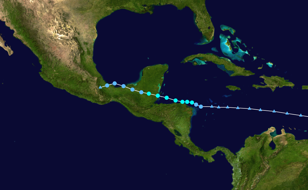
On August 10, a vigorous tropical wave emerged off of Africa, and immediately began to produce an area of concentrated thunderstorms southeast of the Cape Verde Islands. On August 11, the system became more organized as a low pressure centered formed. However, the dry air of the eastern Atlantic penetrated the system, and cloud cover rapidly decreased as the low degenerated back into a tropical wave. The wave continued its journey westward, and convection once again erupted over a large area surrounding the system as it entered the moist waters near the Lesser Antilles. A broad upper-level circulation developed on August 16, but the system lacked a surface low, which inhibited further development as it entered the Caribbean Sea. The system moved due west for another few days before developing a surface low late on August 18, and being classified Tropical Depression Eight.

Eight was already producing rain and wind near the Honduras-Nicaragua border at formation, and conditions worsened on the northern coast of Honduras as the cyclone paralleled this coast, just a few miles offshore. Despite its proximity to land, the system developed deep convection and rain bands about the center, and a jog northeast on August 19 made conditions more favorable for strengthening as the day went on. A well-defined eyewall appeared on the south and west sides of the center during the afternoon, and Eight was named Tropical Storm Harvey shortly after.

The cyclone continued on a westward track through the evening of August 19, and strengthened rapidly, reaching an intensity of 65 mph winds and a pressure of 994 mb before temporarily stabilizing in intensity early on August 20. Since the tropical storm force winds extended only about 20 miles south of the center, (they extended 35 miles north at the time) gale force winds missed Honduras for the most part, although heavy rain fell throughout the region. Harvey continued to maintain the above peak intensity through landfall in Belize, which occurred that afternoon.

After landfall, Harvey continued to move west to west-northwest, and maintained a tropical storm intensity for an impressive 12 hours before weakening into a tropical depression over northern Guatemala. Thunderstorm activity continued throughout the region even as Tropical Depression Harvey crossed from inland Guatemala into inland Mexico on August 21. Later that day, the center, which was still well-defined, jogged to the north, and the depression emerged over the Bay of Campeche. With this new found access to water, Harvey strengthened slightly, but did not regain tropical storm intensity before making a turn to the west-southwest and making landfall in the southern Gulf coast of Mexico early on August 22.

Harvey quickly weakened as it moved inland, and dissipated later that morning. Only minimal damage was sustained, but 3 fatalities occurred from flooding, as Harvey dumped many inches of precipitation over Central America. Since Harvey did not reach hurricane strength, the record of consecutive named storms to not became hurricanes to start the season was extended to eight.


Tropical Storm Harvey shortly after formation.


Track of Harvey.

Monday, August 15, 2011

Tropical Storm Gert (2011)

Storm Active: August 13-16

On August 10, a trough of low pressure developed over the Central Atlantic, associated with a low pressure system to its north. Over the next two days, the low center accelerated northeast, leaving the trough in its wake. The trough formed another weak low pressure center on August 12, as it drifted to the west-southwest at around 10 mph. The convection associated with the low remained very disorganized during the day, but the circulation became more well-defined on August 13, despite the center being partially exposed. More shower activity developed developed later that day, and a deepening of the low sparked the formation of Tropical Depression Seven late that night.

Deeper convection appeared overnight, and Seven intensified into Tropical Storm Gert as the cyclone made a turn to the north on August 14. The outflow of the system improved and the circulation assumed a more rounded appearance early on August 15, and rapid strengthening followed as the cyclone approached Bermuda. Gert reached peak intensity of 65 mph winds and a pressure of 1000 mb later that day. During the afternoon, Gert began a turn to the northeast, passing well to the east of Bermuda, and causing only minimal damage. The cyclone then began to accelerate further, and dry air permeated the system, weakening it overnight and into August 16. Gert quickly lost organization, and was an extratropical cyclone by later that day. Since Gert passed well east of Bermuda, no damage was sustained on the island. Additionally, since Gert did not achieve hurricane status, 2011 became the only year on record in which the first seven named storms did not become hurricanes.


Gert near peak intensity east of Bermuda, on which the cyclone had only minimal impacts.


Track of Gert.

Saturday, August 13, 2011

Tropical Storm Franklin (2011)

Storm Active: August 12-14

On August 10, a large trough of low pressure formed over Florida, with shower activity extending both east into the Atlantic, and west into the Gulf of Mexico. This activity moved generally to the northeast and interacted with a front moving off of the east coast. During the morning of August 12, convection concentrated at a low pressure center on the front, but the elongated nature of the frontal low kept it extratropical through the morning. As it accelerated away from land, the low became well-defined, and became disconnected from the front. As a result, Tropical Depression Six formed that afternoon, just north of Bermuda.

The effects on the island were only to the extent of scattered showers and gusty winds, as Six was tracking quickly away to the northeast. By the morning of August 13, the presence of deep convection within the system allowed it to intensify into Tropical Storm Franklin. Through the morning, thunderstorm activity with this tropical storm continued to increase, and outflow improved in all quadrants, despite increasing shear. Following this increase in organization, Franklin reached its peak intensity of 45 mph winds and a central pressure of 1004 mb during the day. However, Franklin was quickly approaching colder waters, and rapid weakening ensued that evening. By the following morning, Franklin had become extratropical. The remnant low of Franklin tracked east, and was quickly absorbed. The cyclone affected no land.


Tropical Storm Franklin over the open waters of the northwest Atlantic.


Track of Franklin.

Tuesday, August 2, 2011

Tropical Storm Emily (2011)

Storm Active: August 1-7

An intense tropical wave left the African coast during the last week of July, producing a large area of scattered showers and thunderstorms as it moved westward. On July 28, a low pressure center formed on the south side of the system. The low continued to increase in organization, and on July 31, the circulation became associated with the convection in a pronounced swirl of clouds. However, the system was not yet closed, and development was delayed as the low approached the Windward Islands. During the evening of August 1, a burst of convection appeared west of the central low's previous position, accompanied by a circulation organized enough to name the system Tropical Storm Emily.

Due to the initial westward shift of the cyclone, its position at formation was west of the Windward Islands, in the Caribbean Sea. Emily's quick westward motion persisted overnight, bringing the system into the warm open waters of the Caribbean. However, conditions were not ideal for strengthening due to wind shear and dry air near the system, and Emily's center underwent a reformation on August 2, temporarily rendering it stationary. After shifting slightly to the north, the cyclone resumed its track and intensified somewhat as it approached Hispaniola.

Emily became disorganized during the morning of August 3, with the center of circulation becoming exposed and all convection being displaced to the southeast due to moderate wind shear. Despite these factors, Emily maintained its 50 mph intensity throughout the day, and scattered shower and thunderstorm activity reappeared near the center. As a result, heavy rain began to sweep across Haiti and the Dominican Republic. Late that night, the center redeveloped farther east, and Emily was once more temporarily stationary. A huge area of convection appeared about the center as Emily resumed a slow west-northwest motion, and powerful storms raged across Hispaniola early on August 4. The system remained offshore during that morning, but tropical storm force winds and rain covered a portion of the Dominican Republic.

During the afternoon, however, the circulation of Emily became entangled with the mountainous regions of Haiti, causing rapid weakening. By late that afternoon, despite never actually making landfall, all traces of organization were lost and Emily dissipated, leaving only a small trough of low pressure in its wake. The remains of the large area of convection that was formerly associated with Emily slid northward over Hispaniola and into the Bahamas overnight, but some thunderstorm activity reappeared near the trough on August 5, situated just to the south of the eastern tip of Cuba. This activity expanded northward during the day as a low pressure reformed just east of Florida. On August 6, the system became more organized, as the low connected to the new convection, and the low once again became a tropical depression, again being named Emily.

The depression became slightly better organized during that evening, but turned more to the northeast overnight, and the circulation became exposed on August 7 as the center was whisked away from the U.S. east coast. Emily continued to lose organization, and during the afternoon became a remnant low, losing tropical cyclone status once again. Over the next day, the low deepened, and briefly concentrated convection near the center, but it did not exhibit sufficient tropical characteristics to reform. The system was monitored for further development through August 11, but no change occurred, and the remnant low was finally absorbed by a front later that day. 5 deaths and at least $5 million in damages are attributed to Emily.


Emily near its peak intensity of 50 mph winds and a central pressure of 1003 mb.


Track of Emily.

Thursday, July 28, 2011

Tropical Storm Don (2011)

Storm Active: July 27-30

Around July 17, a vigorous tropical wave emerged off of Africa, quickly associating convection with it as it tracked over the open Atlantic. On July 22, it began to affect the Lesser Antilles with areas of heavy rain, and briefly developed a low pressure center. However, a small area of unfavorable wind shear passed over the system, and it remained disorganized. Development was hampered further on July 24, as the wave passed directly over the Dominican Republic and Haiti. During the next few days, this was followed by interactions with Jamaica and Cuba, which kept thunderstorm activity to a minimum. However, on July 26 the wave moved over the waters of the Caribbean south of Cuba. Slow organization occurred over the next day, and by July 27, a low pressure center had formed. During that morning, however, the low lacked a closed circulation and the convection was divided into two hemispheres, with the area of low pressure not directly associated with any one part of the system. Finally, during the afternoon of July 27, a circulation became evident at the northern tip of the system's western half, and the low was upgraded to Tropical Storm Don just north of the Yucatan Peninsula.

A ridge of high pressure to the northeast of Don steered it in a generally northwestward course through the Gulf of Mexico. Over the next day, convection increased, particularly on the southern side of the circulation, and modest strengthening occurred despite shear and dry air from the north. On July 29, the ridge became stronger, and turned Don more to the west-northwest, toward southern Texas. During that day, Don reached its peak intensity of 50 mph and a minimum pressure of 997 mb. The presence of Don generated significant tropical moisture along the northwestern Gulf coast, including Louisiana and parts of Texas. However, as the system made landfall, most rain was concentrated near the center and on the south side, and southernmost Texas therefore received the most rain. Tropical storm force winds enveloped a larger area of the coast, but quickly diminished as Don made landfall. Over land, the system weakened rapidly to a remnant low, causing no damage or fatalities.


Don near peak intensity shortly before landfall in Texas.


Track of Don.

Thursday, July 21, 2011

Tropical Storm Cindy (2011)

Storm Active: July 20-23

On July 19, a low pressure center formed along a stationary frontal boundary situated over the central Atlantic, in the vicinity of Bermuda. This front was the same one that spawned Tropical Storm Bret. The low quickly moved to the east, and deepened over the next day. On July 20, its circulation became increasingly disassociated with the frontal boundary, and the appearance of deep central convection was enough to name the system Tropical Storm Cindy that afternoon.

Even as it formed, it began to accelerate northeastward at speeds over 20 mph. Cindy strengthened rapidly as the circulation became better defined, developing a proto-eye feature early on July 21. The cyclone reached its peak winds, 70 mph, during that morning, and maintained its tropical characteristics through the day. The winds began to decrease as Cindy passed over the cold water north of the 40ÂșN parallel, but the pressure dropped from 1002 to 1000 mb. Additional drops in pressure despite negative changes in wind speed is often a symptom of a cyclone entering extratropical transition, which Cindy did on July 22. However, Cindy's convection was rapidly deteriorating by that afternoon, and the system continued to weaken, becoming a minimal tropical storm by late that night. Cindy was downgraded to a remnant low before actually becoming extratropical early on July 23. The remnant low of Cindy dissipated later the same day, causing no damage.


The low pressure system that formed Cindy mere hours before being classified as a tropical storm.


Track of Cindy.

Monday, July 18, 2011

Tropical Storm Bret (2011)

Storm Active: July 17-22

Following the departure of a cold front from the U.S. east coast, a west-to-east situated stationary front stalled over the Florida coast and adjacent Atlantic waters. On July 16, a weak low pressure center formed in association with this front, and produced an area of showers and thunderstorms off of the eastern Florida coast. The pressure of the system remained high as it drifted slowly southward over the next day, but a clearly defined closed circulation formed during the afternoon of July 17, and the low was upgraded to Tropical Depression Two. Further deepening quickly followed, and the cyclone achieved tropical storm status a mere three hours later.

The newly formed Tropical Storm Bret experienced almost no motion overnight, drifting southward and then eastward, all the while meandering over the Northern Bahamas. Despite some wind shear out of the west that was bringing dry air into the system, convection persisted, and even developed during the morning of July 18, and the strengthening trend continued. Bret even developed a ragged eye amidst its tight circulation that evening, reaching a strong tropical storm intensity of 70 mph winds and a minimum pressure of 995 mb.

However, dry air penetrated the system late that night, causing weakening as the cyclone continued to move slowly north-northeast. As Bret paralleled the southern portion of the U.S. east coast early on July 19, nearly all convection was lost, and the system packed winds of only 50 mph. Some convection returned that morning, and Bret managed to maintain its intensity despite increasing shear from the northwest. With the exception of the southeastern quadrant, which contained some cloud cover, but even it was struggling, Bret had no associated convection whatsoever, and was essentially a bare circulation. Bret moved northeast through the day, and even into July 20 maintained the same intensity, despite very adverse conditions.

The storm finally began to weaken again that evening as it moved over slightly cooler waters, becoming a minimal tropical storm by July 21. Late that night, the storm was downgraded to a tropical depression while located between the Outer Banks of North Carolina and Bermuda. It also underwent significant acceleration to the northeast, reaching speeds over 20 mph. Yet despite the lack of convection, the system persisted as a tropical cyclone through most of July 22, and finally degenerated into a remnant low that afternoon. Bret's only effects were scattered storms and gusty winds in the northern Bahamas.


Bret at peak intensity just northeast of the Bahamas.


Track of Bret.