Thursday, December 29, 2016

2016 Season Summary

The 2016 Atlantic hurricane season had above-average activity, with a total of

16 cyclones attaining tropical depression status,
15 cyclones attaining tropical storm status,
7 cyclones attaining hurricane status, and
3 cyclones attaining major hurricane status.

Before the beginning of the season, I predicted that there would be

14 cyclones attaining tropical depression status,
13 cyclones attaining tropical storm status,
7 cyclones attaining hurricane status, and
3 cyclones attaining major hurricane status.

The season was just a bit above average, since the average numbers of tropical storms, hurricanes, and major hurricanes are 12.1, 6.4, and 2.7, respectively. My predictions at the beginning of the season were close to the actual result, with the only difference being in the number of tropical depressions and tropical storms. The Accumulated Cyclone Energy of the 2016 season was 132, an above average value, since there were a few relatively long-lived and intense hurricanes. In particular, Hurricane Matthew had an individual ACE of about 48, the highest for a single Atlantic hurricane in a dozen years.

The biggest story in 2015 for Atlantic hurricane development was the 2014-5 strong El Nino event. Indicated by anomalously warm ocean temperatures over the equatorial East Pacific region, this event limited the 2015 season to below-average activity. However, by the end of that year, it was diminishing, and fairly neutral conditions prevailed throughout the 2016 hurricane season. Generally speaking, El Nino inhibits tropical cyclone formation and La Nina conditions (with anomalously cool ocean temperatures over the same Pacific region) support it. The near-average 2016 season was consistent with this general rule.

Atlantic ocean temperatures were also not quite as extremely warm as in 2015, but more favorable atmospheric conditions in the Caribbean Sea and Gulf of Mexico allowed systems to form in areas likely to result in landfalls. Hurricane Matthew was by far the most notable hurricane of the season, strengthening into a category 5 in the Caribbean at an unprecedentedly low latitude. It was also the first category 5 in the basin since 2007. The system went on to devastate Haiti with a category 4 landfall, and later affected Cuba, the Bahamas, and the southeastern United States. Some other notable facts and statistics concerning this season include:
  • Hurricane Alex formed in January, making it the first hurricane to form in the month since 1938
  • Following the rapid start to the season with Alex and Bonnie, Tropical Storm Colin and Tropical Storm Danielle became the earliest forming 3rd and 4th tropical storms in an Atlantic season in recorded history
  • Tropical Storm Julia actually formed with its center of circulation over land, marking the first occurrence of this phenomenon since 1988
  • When Hurricane Nicole achieved category 4 status, 2016 became the first known season to have two category 4 hurricanes (the other was Matthew) exist in the month of October
  • The season ended on another unusual note, with Hurricane Otto becoming the southernmost landfalling hurricane in Central America ever recorded, and the first Atlantic storm to cross into the East Pacific basin since 1996
  • Unfortunately, the death toll of the 2016 season exceeded 1700 people (with most of these occurring in Haiti due to Hurricane Matthew), making 2016 the deadliest Atlantic hurricane season since 2005


The 2016 season was not extraordinarily active, but saw a relatively high number of landfalling systems in the Caribbean, the Gulf, and elsewhere.

Sources: https://www.ncdc.noaa.gov/sotc/global/201611, http://www.cpc.ncep.noaa.gov/products/analysis_monitoring/lanina/enso_evolution-status-fcsts-web.pdf

Monday, November 21, 2016

Hurricane Otto (2016)

Storm Active: November 21-26

On November 12, a trough of low pressure making its way across the Caribbean stalled in the southwestern part of the sea north of Panama. The system organized very gradually without moving significantly over a period of many days. Thunderstorm activity increased on the 14th, leading to the formation of a low pressure the next day. The low drifted toward the coastline of Central America, halted, and reversed direction over the following couple of days, while conditions became less favorable and disorganized the system. However, it was still over the same region of warm waters on November 19 when conditions began to improve and the circulation became better defined. On November 20, the low deepened and was better defined still, but thunderstorm activity remained too weak for a tropical cyclone classification. Finally, early on November 21, Tropical Depression Sixteen formed in the southwestern Caribbean.

Located over warm ocean waters and surrounded by an environment of diminishing upper-level winds, the cyclone steadily strengthened. That afternoon, it was upgraded to Tropical Storm Otto. Otto was meanwhile trapped in an area of very weak steering currents and barely moved that day, managing only a slow southward drift. But while the system was nearly stationary, its structure improved considerably: strong thunderstorm activity increased and large curved banding features formed overnight. By midmorning of November 22, Otto was close to hurricane strength and its southern quadrant was bringing heavy rains to the northern coast of Panama. A little more intensification that afternoon resulted in Otto becoming a category 1 hurricane, breaking the record for latest hurricane formation in the Caribbean Sea set by Martha in 1969. Meanwhile, the system began to slowly move westward as a ridge established itself to the north.

The next day, wind shear and dry air weakened Otto slightly back to a tropical storm. This setback was temporary, however, as atmospheric moisture was increasing, and a large burst of intense convection that evening restored hurricane strength. Otto was also moving more steadily westward toward the Central American coast by this time as the ridge amplified. Tropical storm conditions began to affect southeastern Nicaragua and northeastern Costa Rica by the early morning hours of November 24. Around the same time, Otto quickly developed an eye feature and intensified into a Category 2 hurricane, reaching its peak intensity with 110 mph winds and a central pressure of 975 mb. With this intensification, Otto became the latest forming category 2 hurricane on record in the Atlantic basin. A few hours later, around 1 pm EST, Otto made landfall just north of the border of Nicaragua and Costa Rica. This was also the southernmost hurricane landfall in Central America on record. As a result, the storm affected some areas less prepared for landfalling hurricanes.

Soon, however, land interaction began to quickly weaken Otto. By the evening of the 24th it had weakened to a tropical storm. The weakened system, now moving more quickly westward, emerged into the East Pacific basin overnight. The Pacific waters were fairly warm, but Otto faced dry air and significant wind shear. It moved steadily just south of west and weakened until dissipation occurred on November 26.


The above image shows Hurricane Otto at category 2 intensity just before landfall.


Otto's track was unusual in many respects. In addition to becoming the southernmost landfalling Central America hurricane ever recorded, it was also the first cyclone to survive crossing from the Atlantic to the Pacific since 1996.

Wednesday, October 5, 2016

Hurricane Nicole (2016)

Storm Active: October 4-18

During late September, a tropical wave was traversing the central Atlantic. Strong upper-level winds made it difficult for the system to organize, but by October 1, a low pressure center developed and the disturbance was producing strong winds. It moved northwest over the following few days and slowly organized as conditions became somewhat more favorable. By October 3, thunderstorm activity had become more concentrated. The next day, the system was producing winds to tropical storm force, and the circulation became better defined. Therefore, the system was designated Tropical Storm Nicole late in the morning on October 4.

It exhibited organized banding features and a well-defined circulation through the next day despite moderate shear. Meanwhile, the small system moved generally west-northwest into October 5. The cyclone continued to defy somewhat unfavorable atmospheric conditions and rapidly intensified over the following day, achieving hurricane status during the afternoon of October 6. An eye appeared on satellite imagery at the same time, and Nicole sped to an intensity of 105 mph winds and a pressure of 968 mb. The cyclone then stopped in its tracks and reversed course toward the south by October 7. Wind shear increased drastically and weakened Nicole as quickly as it had strengthened in addition to periodically exposing the center. By October 8, the system was again a fairly weak tropical storm, though vigorous convection bursts appeared intermittently throughout the day.

Nicole once again slowed to a standstill overnight and upper-level winds slowly relaxed. This allowed the system to recover some organization and initiate a slow strengthening trend. Later on October 9, Nicole finally assumed a more typical northward motion after meandering over the open Atlantic for several days. The next day, the system was again a strong tropical storm. However, the system still struggled with some dry air aloft even as it passed over very warm waters. It managed to develop a ragged eye feature during the morning of October 11, and intensification restarted. In fact, the system rapidly intensified into a hurricane that evening, and a category 2 storm by early on October 12. By this point, the cyclone was moving north-northwestward toward Bermuda. Later that day, the eye became quite large and symmetric and the system had outstanding outflow in all quadrants. These new increases in organization merited an upgrade to a major hurricane that evening and Nicole reached category 4 status briefly that night. Its peak intensity of 130 mph winds and a minimum pressure of 950 mb occurred as the system accelerated toward the north and tropical storm force winds began to engulf Bermuda.

Just after achieving peak intensity, the cyclone experienced a huge increase in wind shear, causing significant weakening to begin early on October 13. Nicole's center passed within 10 miles of Bermuda that morning with the cyclone still at category 3 strength, bringing hurricane force sustained winds to the island. By this time, the system was turning toward the northeast and gaining forward speed. Meanwhile, shear and decreasing ocean temperatures quickly weakened Nicole back to category 1 strength. The system acquired some extratropical characteristics the next day, but rather than transitioning fully, it became a sort of hybrid cyclone: the windfield and size of the system were typical of an extratropical system, but the inner core remained that of a tropical cyclone.

Late on October 14, Nicole briefly weakened to a tropical storm, but baroclinic processes reintensified the system the next day to a very powerful north Atlantic hurricane. It also turned toward the east on October 15 and slowed in forward speed. By the next morning, it had maximum winds of 85 mph and a pressure of 958 mb and was generating large ocean swells throughout the north Atlantic. Some weakening ensued the following day, but Nicole remained a hurricane through the morning of October 17. Diminishing ocean temperatures finally caught up to the system that night, purging the remaining tropical characteristics, and Nicole became post-tropical early on October 18. The cyclone remained extremely powerful for the next few days as it interacted with a frontal low and brought unusually strong winds to the southern coast of Greenland before being absorbed.


The above image shows hurricane Nicole at peak intensity shortly before impacting Bermuda. Since Matthew and Nicole both were category 4 hurricanes in October, the 2016 season was the first in recorded history to have two storms of at least category 4 strength in this month.


Nicole's meandering track brought it southward before doubling back toward Bermuda, stalling over the far northern Atlantic, and finally having impacts as far north as Greenland as an extratropical system.

Thursday, September 29, 2016

Hurricane Matthew (2016)

Storm Active: September 28-October 9

On September 22, a tropical wave exited in the African coast and moved rapidly westward across the Atlantic. For the next few days, the wave remained south of 10°N and embedded in the Intertropical Convergence Zone. Combined with the dry air over the east Atlantic, this factor precluded development initially. By the 26th, thunderstorm activity had increased and spiral bands had begun to appear on the north side of the disturbance. The system was still too far south to acquire spin, but it began to move west-northwest over the following day and acquired additional organization. By September 27, the wave was generating winds to near tropical storm force, but had not yet developed a closed circulation. Early on September 28, the system appeared on satellite imagery to be more organized, and aircraft reconnaissance confirmed the presence of a closed circulation later that day. Therefore, advisories were initiated on Tropical Storm Matthew. The aircraft also estimated that surface winds of 60 mph were already present, making the newly formed Matthew already a strong tropical storm.

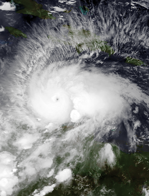
At the time of formation, Matthew was passing through the Lesser Antilles and entering the Caribbean, bringing strong storms to the region. During the morning of September 29, moderate shear out of the southwest exposed the center briefly. However, high ocean temperatures and increasing humid air near the system allowed an inner core to quickly develop. By the middle of the afternoon, Matthew had strengthened to a hurricane. Meanwhile, the cyclone veered slightly south of west. Overnight, strengthening continued, bringing Matthew to category 2 status by the morning of September 30. Conditions began to deteriorate in the northernmost areas of Columbia later that morning. It is very unusual for tropical cyclones to affect South America, but Matthew's track was quite far south through the Caribbean. Around the same time, an eye appeared on satellite imagery and further rapid intensification took place. That afternoon, the system vaulted through category 3 and up to category 4 status. During the late evening, Matthew peaked as a category 5 hurricane with winds of 160 mph and a central pressure of 941 mb, making it the first category 5 hurricane in the Atlantic since Felix in 2007. Achieving this intensity at 13.3°N latitude, it was also the southernmost category 5 hurricane ever recorded in the Atlantic.

The forward speed of the system had slowed considerably at this point, although it was still moving west or just south of west. Early on October 1, the eye shrunk and the inner core became less organized, resulting in some weakening that day. This weakening was temporary, however, for after completing a small cyclonic loop that afternoon, Matthew regained strong category 4 strength and its new lowest pressure of 940 mb. The cyclone's motion remained slow and somewhat erratic through the following day, averaging to a general northwestward track during the day of October 2. Later that day, the outer rain bands of Matthew began to affect Jamaica and Haiti as it approached from the south. The system turned to the north and experienced slight weakening that night, but still maintained category 4 intensity. Matthew's structure did not change much the next day as it steadily approached the Greater Antilles. Extremely heavy rains began over Haiti on the 3rd and continued as the storm came closer and closer. Early on October 4, the center passed well to the east of Jamaica, though the island still experienced tropical storm conditions. Meanwhile, Matthew's pressure dropped to 934 mb, though the winds remained within category 4 intensity. Around 7:00 am EDT on October 4, Matthew made landfall in southwestern Haiti with maximum winds of 145 mph, the strongest hurricane to make landfall in the country in over 50 years.

Interaction with land began to slowly weaken the system, though the inner core remained largely intact. The cyclone emerged over water a few hours later and traversed the channel between Cuba and Haiti that day. It remained a category 4 with 140 mph winds when it made landfall near the eastern tip of Cuba at 8:00 pm EDT that evening. The cyclone stalled its northward motion slightly over land and weakened more substantially, becoming a category 3 storm early on October 5. By that time, it had again emerged over water and was entering the Bahamas. An amplifying ridge to the cyclone's east caused a northwest turn later that day. Meanwhile, Matthew began to recover from its land interactions that evening, with the pressure dropping and winds increasing as the eye passed through the Bahamas. Later on October 6, Matthew peaked as a category 4 once again. Rain bands had begun to affect Florida's east coast at this point and the cyclone continued to move closer to land, turning toward the north as it did so. Overnight, the center moved roughly parallel to the central and northern Florida coastline, with the outer eyewall bringing strong winds and heavy rains to the coastline from about 30 miles offshore.

Land interaction and increasing shear also started to weaken the storm as it moved northward. By the time it passed the coast of Georgia very early on October 8, the winds had diminished to category 2 strength. Matthew continued its turn and began to move northeast parallel to the U.S. coastline before finally crossing the shore late that morning as a category 1 hurricane in central South Carolina. Though the maximum winds had decreased by this point, very high levels of moisture in the atmosphere contributed to a huge rainfall event for the Carolina coasts, with over 10 inches of rain falling over a large swath of the region. In addition, the cyclone produced a large storm surge that inundated some low-lying areas. However, by this point, the hurricane was quickly acquiring extratropical characteristics, and transition was completed early on October 9. Though the system was moving eastward away from the coast, rains continued in the Outer Banks of North Carolina through the day before tapering off. The extratropical system was absorbed by a front the next day.


Hurricane Matthew was the first category 5 hurricane in the Atlantic in 9 years. The storm killed over 1000 people, a majority of whom lived in Haiti, making it the deadliest cyclone in the Atlantic since 2005. It also caused over five billion dollars in damages and was the costliest Atlantic hurricane since Hurricane Sandy of 2012. The above image shows the cyclone at peak intensity in the Caribbean Sea.


Matthew formed and strengthened unusually far south in the Caribbean before turning sharply northward and impacting the Greater Antilles, the Bahamas, and the U.S. east coast.

Tuesday, September 20, 2016

Tropical Storm Lisa (2016)

Storm Active: September 19-24

On September 16, a tropical wave moved off of Africa into quite favorable conditions in the eastern Atlantic. As a result, an area of low pressure developed almost immediately and an impressively broad circulation developed. After initially having some trouble consolidating, the circulation became well-defined on September 19 and the system was classified Tropical Depression Thirteen. Shortly after formation, the depression took a west-northwest turn toward a weakness in the ridge to its north. Steady organization followed over the next 24 hours as the system strengthened into Tropical Storm Lisa during the morning of September 20 and then experienced more strengthening through that evening.

Due to the presence of an upper-level low pressure system located to the northwest of Lisa, shear out of the west and southwest began to increase dramatically on September 21, gradually exposing the center of circulation as convection retreated to the east. Lisa held its own, however, continuing to produce very deep convective bursts. It even rebounded from a momentary weakening that day by strengthening to its peak intensity of 50 mph winds and a pressure of 999 mb during the morning of September 22. There was evidence by this point that the circulation was becoming elongated in response to the continued shear. Meanwhile, thunderstorm activity began to wane and Lisa weakened through the rest of the day and overnight.

The storm experienced once last resurgence of thunderstorms during the morning of the 24th and in fact was upgraded back to tropical storm status as a result. However, this was only a temporary reprieve. By that afternoon, the circulation was entirely bare. Lisa was downgraded to a tropical depression that afternoon and a remnant low that night. The circulation produced shower activity for an additional few days before dissipation.


The image shows a disorganized Lisa over the eastern Atlantic.


A break in the ridge to Lisa's north allowed it to veer north quite far east and encounter hostile atmospheric conditions quite quickly.

Thursday, September 15, 2016

Tropical Storm Karl (2016)

Storm Active: September 14-25

On September 12, a tropical wave near the African coastline began to show signs of development. Beginning the next day, gusty winds and locally heavy rain began to affect the Cape Verde Islands as the disturbance moved west-northwest toward them. The system acquired a surface circulation fairly rapidly and was classified Tropical Depression Twelve on September 14, while still over the islands. Moderate wind shear out of the west kept the center exposed and prevented strengthening over the next day. Late on September 15, however, organization markedly increased and the depression intensified into Tropical Storm Karl.

The next day, thunderstorm activity was pushed a bit farther away from the center by the wind shear, and Karl lost some organization. Additionally, the system took a turn to slightly south of due west by the morning of the 17th. Slight weakening followed, though Karl remained essentially steady state through September 18. The system's direction did change toward the west-northwest, and Karl began to gain latitude. Late on September 19, it appeared that the system was finally starting to organize as shear diminished, but thunderstorm activity collapsed into disorder again the next morning. Upper-level winds had not abated as anticipated, and the Karl in fact weakened to a tropical depression late on September 20th.

The long-awaited relaxation of shear commenced the following day, and the overall structure of Karl became much more symmetric, with banding features and deep convection on all sides of the circulation. This large-scale improvement was unusually not accompanied by any development of the inner core. Rather, it remained broad, rather like a pre-tropical system. As a result, Karl remained a tropical depression through the morning of September 22, still moving northwestward over the open Atlantic. Later that day, the cyclone finally began to strengthen, regaining tropical storm strength that evening and continuing to intensify through the morning of September 23 as outflow drastically improved. The system began to round the edge of the subtropical ridge that day and turned toward the north.

Conditions worsened in Bermuda throughout the day as Karl approached, eventually escalating to tropical storm force winds and heavy rains overnight. The center turned to the northeast just short of Bermuda early on September 24 and the system began to quickly accelerate away from the island. Wind shear was high across the system, but as it was beginning to undergo extratropical transition, there was some increase in intensity that day, bringing Karl to its peak of 70 mph winds and a pressure of 990 mb that night. By the morning of September 25, the cyclone was speeding northeast at almost 50 mph and was declared extratropical.


The above image shows Karl just after passing Bermuda.


Despite existing as a tropical cyclone for 11 days, Karl was never able to intensify into a hurricane.

Wednesday, September 14, 2016

Tropical Storm Julia (2016)

Storm Active: September 13-18

On September 8, a tropical wave located east of the Lesser Antilles began to exhibit some signs of organization. However, atmospheric conditions were rather hostile, so the system moved west-northwest and then northwest for several days without significant change. On September 11 and 12, the disturbance brought some storms to the Bahamas as it passed through. Surface pressures remained high, so not development occurred during that time. That night, the circulation center of the low moved over the Florida peninsula. Despite this, the warm waters just to the east fueled a huge increase in convection just offshore and caused the system to strengthen. Late on September 13, the low was upgraded to Tropical Storm Julia even while the center was just inland over northeastern Florida. Julia was the first Atlantic storm to form over land since 1988.

After moving northward overnight and crossing inland into Georgia, the center reformed farther east on the 14th and moved over water. Though land interaction lessened, wind shear increased out of the west. This made it difficult for Julia to develop thunderstorm activity over the center and the system weakened to a tropical depression by the morning of September 15. Now moving slowly eastward, Julia put some distance between itself and the coast, ending significant rainfall over the Carolinas and Georgia and averting a potential flooding event. That night, new convective bursts including gale force winds indicated that the system was once again a tropical storm.

Over the next day, the forward motion of Julia slowed to a standstill and it lost organization as hostile conditions continued. As a result, it was again downgraded to a depression by the morning of September 17. The cyclone maintained no persistent convective features that day, but intermittent bursts were enough to maintain the cyclone as tropical. In the meantime, the center of circulation adopted a slow northwestward drift. Soon, however, dry air finally overwhelmed the system, and it was downgraded to a remnant low the evening of September 18. The low continued northwestward slowly until it merged with a front near the coast of North Carolina.


The above image shows Tropical Storm Julia shortly after formation over Florida. Most convection associated with the system remained offshore to the east.


Julia meandered near the U.S. southeast for several days before wind shear and dry air destroyed the system.

Monday, September 12, 2016

Tropical Storm Ian (2016)

Storm Active: September 12-16

Near the end of September's first week, a tropical wave developed over the central Atlantic. Soon, a low pressure center developed along the southern portion of the wave and began to produce a large area of showers and thunderstorms. Despite conditions being very favorable for development, the system organized only slowly as it moved northwestward. By late on September 11, the low was producing gale-force winds. However, it did not yet possess a well-defined center of circulation. Despite the fact that upper-level winds had increased somewhat, the low managed to organize into Tropical Storm Ian during the morning of September 12.

Convection remained confined to the northeast of the center through the remainder of that day. Meanwhile, the system turned toward the north-northwest well to the east of the Lesser Antilles. The area of tropical storm force winds did experience an expansion that evening, and maximum winds increased somewhat, but Ian's structure did not meaningfully change until the afternoon of the 13th. At that time, convection managed to cover the center for the first time. However, the cyclone began to lose tropical characteristics shortly afterward, with the circulation becoming broader and losing concentrated thunderstorm activity near the center. By the morning of September 15, it was accelerating north-northeast over the open Atlantic. Ian actually appeared more tropical later that day than it had for a couple days, with deep convection reappearing close to the circulation center. However, it was racing toward the north Atlantic by this time, briefly achieving a forward speed of over 50 mph that night. At the same time, it experienced some intensification, reaching 60 mph winds and a pressure of 994 mb by the morning of September 16. The cyclone in fact continued strengthening as it became extratropical that afternoon. It merged with another strong low over the north Atlantic shortly afterward.


The image above shows Tropical Storm Ian shortly after formation.


Ian did not affect any landmasses over its short lifetime as a tropical cyclone.

Monday, August 29, 2016

Hurricane Hermine (2016)

Storm Active: August 28-September 3

On August 18, a tropical wave just southwest of the Cape Verde Islands began to display scattered shower activity. The system remained rather broad and disorganized during its trek westward across the Atlantic for most of the following week. Throughout much of this period, the wave and associated low were little more than an large swirl of sparse clouds with limited convection farther south. This was due to the influence of the Saharan air mass to the north. Organization increased some around the 22nd and 23rd as the low passed through the Lesser Antilles, but a well-defined circulation did not yet develop. In fact, organization decreased markedly over the following several days, as the convection became scattered across many of the islands of the Caribbean away from the center. It was not until the system passed just south of the Florida Keys on August 28 that it finally acquired the status of Tropical Depression Nine.

The location of the center of circulation remained difficult to spot on satellite imagery through the next day, but convection increased overall, particularly to the south of the center. This caused heavy rains for much of western Cuba. Organization increased markedly on August 30 and the subsequent overnight period: a large area of very deep convection developed over the southeastern Gulf of Mexico surrounding the center and the central pressure dropped appreciably. This did not immediately correspond to an increase in maximum winds, but aircraft data collected the afternoon of August 31 indicated that the system had finally strengthened into Tropical Storm Hermine.

By this time, the cyclone had assumed a track toward the north-northeast due to the influence of a trough over the southeastern United States. At the same time, atmospheric conditions improved, allowing Hermine to take advantage of the very warm Gulf waters and intensify quickly. That evening, the storm developed more organized banding features, with a huge band extended from northwest to southeast of the center. Shortly afterward, this band began to affect the Florida panhandle. By the morning of September 1, heavy rain was moving across western Florida as far south as Tampa. An eyewall appeared later that morning and completed its circumnavigation of the center that afternoon. Hermine became a category 1 hurricane soon after. A few hours later, the cyclone reached its peak intensity of 80 mph winds and a central pressure of 984 mb and made landfall in the Florida panhandle, causing storm surges of several feet, strong winds, and over 5 inches of rain for many areas.

Hermine weakened to a tropical storm overnight and move inland over Georgia by the morning of September 2. The cyclone traversed South Carolina that afternoon and entered North Carolina that evening. All the while, it weakened and gradually lost tropical characteristics. This did not prevent it from causing flooding rains from the Carolinas north to the Delmarva peninsula by the morning of September 3. Around this time, Hermine became post-tropical and moved east-northeast back over water. There it reintensified some and developed winds near hurricane force. While storm surge remained a threat to the coast, the system moved farther away from land over the next day, lessening direct impacts. Early on September 5, Hermine changed course, moving first slowly northward, and then toward the west-northwest by the afternoon. Though it remained post-tropical, the system generated some shallow convection to the north and west of the center, bringing continued shower activity to coastal New England. The circulation began to spin down on the 6th, and while it moved a little closer to the coast, impacts diminished. By September 7, the weakening cyclone had switched direction and was moving generally east-northeast. It dissipated shortly after.


The above image shows Hermine shortly after it became a hurricane.


Hermine continued to affect the U.S. east coast even after transitioning to a post-tropical cyclone (post-tropical track points are indicated by triangles).

Sunday, August 28, 2016

Tropical Depression Eight (2016)

Storm Active: August 28-31

On August 26, an area of showers and thunderstorms developed in association with a low pressure system just south of Bermuda that had originated from a stalled frontal boundary. While the atmosphere was fairly dry, organization increased over the next day as the low moved toward the west-northwest. By the evening of August 27, the system had developed a roughly circular area of convection with the center of circulation on the eastern edge. The next morning, it was well-defined enough to be classified Tropical Depression Eight. Over the next day, shower activity blossomed only intermittently, leaving the circulation bare a majority of the time. Thus the system remained a tropical depression into August 29 as it turned toward the northwest. Its forward speed also decreased as it moved toward a break in the subtropical ridge to its north. As a result, it stalled off the coast, missing the Outer Banks of North Carolina by less than 100 miles. As a result, scattered showers and gusty winds affected portions of eastern North Carolina on August 30.

Later that day, Eight began to move slowly northeast away from the U.S. east coast. At the same time, the depression lost organization as it began to interact with a frontal boundary just off of the U.S. east coast. Convection became well displaced from the remaining circulation, and the system opened up into a trough early on August 31.


The above image shows Tropical Depression Eight near the coast of the Carolinas.


Tropical Depression Eight faced marginal conditions at best for development throughout its short lifetime.

Monday, August 22, 2016

Hurricane Gaston (2016)

Storm Active: August 22-September 3

During mid-August, a vigorous disturbance developed well inland over the continent of Africa. The potential development of this system once it emerged into the Atlantic was identified by August 17, three days before it encountered water. By the time it had moved over the ocean on August 20, a small area of thunderstorm activity persisted near its circulation center. Organization continued over the next few days and Tropical Depression Seven formed over the eastern Atlantic during the afternoon of August 22. Initially, conditions were favorable for development as the cyclone moved westward, and it quickly strengthened into Tropical Storm Gaston. The one inhibiting factor for rapid intensification over the following day was the Saharan dry air mass located to the north. Some of this air entered the circulation on the 23rd, forming a large eye-like structure near the center of circulation. However, Gaston managed to develop a central dense overcast shortly thereafter and became a strong tropical storm. Meanwhile, the system took a turn toward the northwest. As it was nearing hurricane strength on August 24, wind shear increased, slowing development. Nevertheless, the system overcame increasing upper-level winds out of the southwest to achieve hurricane status early on August 25, becoming the third hurricane of the 2016 Atlantic season.

However, the deteriorating atmospheric conditions soon disrupted Gaston's circulation, weakening it back to a tropical storm later that day. Squeezed between a upper-level low (the source of the shear) and a ridge to its north, the system moved rather quickly toward the northwest for the remainder of that day and gradually weakened. The next day, shear abated and the tropical storm began to reorganize. As a result, strengthening began once again by the morning of August 27. While Gaston was still moving northwestward, its forward speed slowed considerably that day. An eye feature developed overnight, and steady strengthening continued through the morning of the 28th, bringing the cyclone to category 2 hurricane status. That evening, the system slowed to a standstill and became the first major hurricane of the season. Just afterward, it reached an intensity of 120 mph winds and a pressure of 957 mb.

By August 29, Gaston had gained enough latitude to be affected by the mid-latitude westerlies and began a turn toward the northeast. The cyclone came off its peak intensity that day as the eye clouded over temporarily. However, once the eyewall replacement cycle was complete that night, a very large, symmetrical eye appeared on satellite imagery. Therefore, Gaston strengthened once again during the day of August 30 and regained major hurricane status that night, matching its peak winds of 120 mph and beating its former minimum pressure by achieving a mark of 956 mb. However, cooler water and increasing shear finally began to take their toll the next day and a steadier weakening began as Gaston accelerated off to the east-northeast. By the evening of August 31, the winds had decreased to category 1 intensity and the convection had become asymmetrical. This is typical of system beginning to lose tropical characteristics, and the trend continued into September 1, by which time only the northern side remained of the eyewall.

The remaining thunderstorm activity became decoupled from the center that evening as the cyclone took another turn toward due east. On September 2, Gaston weakened to a tropical storm and moved into the Azores. Later that day, however, most of the cloud tops disappeared, leaving a bare circulation. As a result, the system became post-tropical early on September 3. It was absorbed by a large extratropical system about one day later.


Hurricane Gaston achieved its second peak intensity on August 30, at which time its structure included a very large eye (above).


Gaston was the second tropical cyclone of the 2016 season to affect the Azores, after Hurricane Alex in January. For two such storms to affect the Azores in a season is highly unusual.

Wednesday, August 17, 2016

Tropical Storm Fiona (2016)

Storm Active: August 16-23

On August 14, a tropical wave formed near the western coast of Africa and began to produce a large region of disorganized thunderstorm activity. Over the next couple days, the system moved generally west-northwestward and developed a small but vigorous circulation. Late on the 16th, the system was designated Tropical Depression Six. Water temperatures were warm in the region and wind shear was abating. However, as with many tropical cyclones in the central Atlantic, the depression had to contend with low humidity values in the surrounding air that constantly threatened to overwhelm the small system.

On August 17, a small concentrated burst of convection replaced the larger but less powerful banding features, resulting in the cyclone's upgrade to Tropical Storm Fiona. Thunderstorm activity waxed and waned over the next day following the usual cycle by which convection preferentially forms at certain times of day due to solar heating of the ocean and atmosphere. Overall, Fiona's intensity remained virtually unchanged on August 18. Meanwhile, the cyclone moved generally northwest in towards a gap between high pressure systems centered in the east Atlantic and near Bermuda. Wind shear increased somewhat on August 19 but water temperatures continued to climb as Fiona traversed anomalously hot waters in the central Atlantic. As a result, bursts of convection continued to form. Fiona fluctuated in intensity a bit but this state of affairs remained mostly unchanged through the day on August 20. Overnight, the circulation center became exposed again, and the cyclone weakened to a tropical depression. Fiona struggled more to develop a convective canopy on the 21st, but it held its own enough to remain a depression through the day.

Over the following two days, the system continued to wane, with the circulation becoming elongated by August 23. This, coupled with a lack of persistent convection, prompted its downgrade to a remnant low that morning. The low continued west-northwestward for another few days before it dissipated over the western Atlantic.


Tropical Storm Fiona struggled with dry air for most of its lifetime.


Fiona did not approach land at any time during its trek through the central Atlantic.

Tuesday, August 2, 2016

Hurricane Earl (2016)

Storm Active: August 1-6

On July 25, a tropical wave formed just off of the African coast. It moved at an unusually fast rate (around 30 mph) across the eastern and central Atlantic, being among the first of the season to exhibit vigorous shower activity this far east. However, conditions were not very favorable and it is in any case more difficult for fast-moving systems to develop organized circulations. During the final two days of July, convection increased with the wave and it brought rainfall to the Lesser Antilles as it passed westward into the Caribbean Sea. Only toward the end of this period, however, did surface pressures begin to fall in the region. Organization increased significantly by early on August 1 as a large, roughly circular area of thunderstorm activity developed, bringing some rain and high winds to Puerto Rico as it passed to the south. However, it was not until August 2 that a closed circulation was identified. Since the system already had tropical storm force winds, it was designated Tropical Storm Earl as it passed quickly to the south of Jamaica.

Earl was quite disorganized at first, but shear lessened and the storm's forward motion slowed significantly later that day. Combined with the quite high sea temperatures of the western Caribbean, these factors allowed the cyclone to strengthen overnight as its southern bands swept across Honduras. The circulation of Earl had become quite broad by the afternoon of August 3, resulting in heavy rainfall for larger portions of Honduras even as the center remained offshore. Hints of a mid-level eye appeared intermittently throughout the day and by the late afternoon Earl had become a category 1 hurricane. It did not have much time to strengthen further, however. At around 2:00 am EDT, August 4, Hurricane Earl made landfall in central Belize at its peak intensity of 80 mph winds and a minimum central pressure of 979 mb. Hurricane-force winds affected an area near Belize City, and total rainfall amounts of 8-12 inches were common in the central peninsula.

Earl rapidly weakened as it moved inland. By the time it crossed into Guatemala, it was again a tropical storm. That evening, the center took a trajectory just north of west, bringing a the circulation toward the southernmost waters of the Bay of Campeche. As a result, weakening had halted by August 5, with Earl still clinging to minimal tropical storm strength as it continued generally westward. Significant convective bands redeveloped in association with the system as the center traveled over water that morning and through most of the afternoon. The tropical storm strengthened unexpectedly during this period, enhancing the rainfall totals for regions of Mexico. That evening, Earl made landfall in Mexico with maximum winds of 60 mph. Rapid weakening commenced over land, and the system dissipated over the mountainous terrain the next day. Having crossed Mexico, the remnants of Earl contributed to the development of Tropical Storm Javier in the Eastern Pacific basin on August 7.


Earl is shown above near peak intensity on August 3, about 5 hours prior to landfall in Belize.


The high ocean temperatures of the western Caribbean Sea were favorable for Earl's intensification, but its rapid movement and interaction with land prevented it from more than a minimal hurricane.

Sunday, June 19, 2016

Tropical Storm Danielle (2016)

Storm Active: June 19-21

A tropical wave moved over the eastern Atlantic from Africa during the first week of June. However, it being so early in the hurricane season, the system had no opportunity to develop further for nearly two weeks, when it began to produce thunderstorm activity near the coast of Nicaragua on June 15. The wave continued generally west-northwestward for the next few days, during which time land interaction inhibited organization. On June 18, it emerged into the Bay of Campeche, and a low pressure center formed in association with the wave. During the next day or so, moderate wind shear affected the system, hindering convective banding. However, the center of circulation became better defined on June 19 as shear gradually lessened, while increasing shower activity showed hints of banding in the northern semicircle. As a result, the system was designated Tropical Depression Four.

After a brief lull in convective activity that evening, a large area of deep convection blossomed overnight, albeit not all that organized about the center of circulation. By the morning of June 20, reconnaissance aircraft discovered gale force winds in the system, prompting an upgrade to Tropical Storm Danielle. This was the earliest naming of a fourth storm in the history of Atlantic hurricane seasons, beating out the record set by Tropical Storm Debby in 2012 by 3 days. Heavy rain began over the Mexican coast on the west side of the Bay of Campeche and continued as Danielle moved west-northwestward toward land. Danielle reached its peak intensity of 45 mph winds and a minimum pressure of 1007 mb before making landfall in Mexico that evening. The storm brought 8-12 inches of rain to a large area of Mexico as it quickly weakened over the mountainous terrain of Mexico. It dissipated early on June 21.


During its brief period as a tropical system, Danielle brought heavy rains to eastern Mexico.


Forming in the central Bay of Campeche, Danielle did not have time to strengthen significantly before it moved westward over land.

Sunday, June 5, 2016

Tropical Storm Colin (2016)

Storm Active: June 5-7

Around June 3, a large area of disturbed weather formed over the northwestern Caribbean Sea. The next morning, a broad low-pressure center developed in association with the system just east of the Yucatan Peninsula. Moving over land that day, it was unable to organize further and convection remained over water well to the east. On June 5, however, the center emerged into the Gulf of Mexico. Shortly after, the low had acquired enough organization to be classified Tropical Depression Three. Due to shear out of the west, the depression's thunderstorm activity, though significant, was located in a north-to-south linear band over 100 miles east of the circulation center. Despite this disorganization, hurricane hunter aircraft discovered winds to tropical storm force that afternoon, prompting an upgrade to Tropical Storm Colin. The formation of the year's third named storm on June 5 broke the record for earliest third tropical storm, set on June 12, 1887. This record was then surpassed by Tropical Storm Cristobal in 2020.

Colin exhibited a very curious structure for a tropical cyclone. Overnight and into June 6, it was apparent that there were at least two distinct low-level centers widely separated from one another, both of which lay outside the intense area of convection to the east. The size of the system and its disheveled state were prohibitive to significant strengthening. Despite this, the impacts of the storm remained: by June 6, with Colin still over water, heavy rains spread throughout much of Florida, Georgia, and even South Carolina. The system consolidated a bit that day into a single circulation, albeit with several small-scale gyres. Meanwhile, it was accelerating rapidly toward the northeast. That evening, the center of Colin made landfall in the Big Bend region of Florida (although most of the rainfall had moved off to the east by this time).

Though at its peak intensity as a tropical system of 50 mph, the system was more disorganized than ever as it sped off to the northeast, quickly emerging off the coast of the Carolinas early on June 7. At this point, Colin was rapidly losing tropical characteristics, and it become post-tropical near the Outer Banks later that morning. By the afternoon, the system had moved away from land, still intensifying as a post-tropical system. It continued to speed toward the far northern Atlantic before being absorbed a few days later.


Colin remained disorganized during its brief stint as a tropical system. The above satellite image, taken June 6, shows multiple vortices exposed to the west of the convective canopy.


Colin made landfall in Florida on June 6 before quickly moving out to sea.

Friday, May 27, 2016

Tropical Storm Bonnie (2016)

Storm Active: May 27-30, June 2-4

Around May 24, a broad area of scattered showers and thunderstorms began to develop in association with a low-pressure trough situated to the north of Hispaniola. Over the next few days, convection gradually became more concentrated near the low-pressure center as it deepened and moved generally toward the west-northwest. By the afternoon of May 27, the circulation had become well-defined with a curved band of strong thunderstorms just to the north and west of the center. This resulted in the designation of the system as Tropical Depression Two.

Overnight, the system continued west-northwestward toward a tongue of warmer Gulf Stream waters off of the coastline of South Carolina. Even as it encountered higher sea surface temperatures, however, significant wind shear out of the south kept the center exposed through the day of May 28. By that morning, rain bands had begun to affect the U.S. coastline. The convection deepened somewhat that afternoon and the circulation became better defined, so the system was named Tropical Storm Bonnie. Since Bonnie was named before the official start of the season on June 1, 2016 became the first year since 2012 to have multiple preseason storms. A few hours later, the storm reached its peak intensity of 45 mph winds and hesitated slightly in its forward motion.

Shortly afterward, however, a large burst of wind shear out of the south ripped the existing convection away from Bonnie, weakening it overnight just before its landfall in South Carolina as a tropical depression during the morning of May 29. Despite the decay of the system, heavy rainfall continued for a large region of the southeast U.S. through the day. Shortly afterward, the cyclone took its anticipated turn toward the north east over land. By the morning of May 30, the system had weakened sufficiently that it no longer met the criteria of being a tropical cyclone. Bonnie's remnants continued to generate shower activity as the center moved slowly northeast back over the Atlantic Ocean on May 31.

In fact, the system became more organized back over water, slowly redeveloping convective bands and increased sustained winds. By the morning of June 2, it had regained tropical depression status near the Outer Banks. That day, the Bonnie strengthened slightly over the warm Gulf Stream waters as it moved away from land, but remained slightly below tropical storm strength. Meanwhile, it began to accelerate eastward under the influence of a subtropical ridge. Overnight, the system seemed to be on the wane as it moved over cooler water and convection diminished, but a resurgence during the afternoon of June 3 prompted once again upgrading Bonnie to a tropical storm. However, very cold water finally took its toll on the storm on June 4: it lost all significant shower activity, weakening to a tropical depression, and shortly thereafter, a remnant low. The remnants moved east-southeast for another couple of days before dissipation.


The above image shows Bonnie shortly before landfall in South Carolina.


Bonnie's slow motion near the U.S. coastline as both a tropical and a non-tropical system brought torrential rains to the Carolinas.

Wednesday, May 18, 2016

Professor Quibb's Picks – 2016

My personal prediction for the 2016 North Atlantic Hurricane Season (written May 18, 2016) is as follows:

14 cyclones attaining tropical depression status*,
13 cyclones attaining tropical storm status*,
7 cyclones attaining hurricane status*, and
3 cyclones attaining major hurricane status.
*Note: Hurricane Alex formed on January 13, long before the official start of the season on June 1 and before I made these predictions.

This prediction calls for a nearly average Atlantic hurricane season, with predictions just barely exceeding historical averages in all categories.

The picture for the 2016 Atlantic hurricane season is unusually murky, due to several uncertainties regarding significant factors that influence tropical cyclone formation. First, the 2015-16 El Niño event has continued to unfold, ranking in the top 3 historically in both intensity and duration. Positive sea surface temperature anomalies have persisted into May in the equatorial Pacific, indicating the continuation of the event. The chart below compares El Niño events since 1950.


The 2015-16 event (black line) is probably most comparable to the 1997-98 event in its qualities, so if this trend were to repeat, the 2016 season would end with the ENSO in a negative phase. However, it has occurred that El Niño events persist to the end of the second year, or that they become roughly neutral. A neutral ENSO (El Niño Southern Oscillation) index, all else held equal, would lead to an average hurricane season, and a negative index to a more active season. The latest predictions indicate that neutral conditions will in fact prevail during the season's peak in September and October, but there is a great deal of uncertainty.

Second, the Atlantic Multi-Decadal Oscillation (AMO) (an empirically observed trend in tropical cyclone activity that has decades-long period) appears to be wrapping up the positive phase that led to busier hurricane seasons during the 2000's and early 2010's. However, this trend is harder to predict than the ENSO, and while some meteorological experts believe that it is now entering its negative phase, it is difficult to know for certain. The combination of these two factors yield an expectation of an average season, but with an unusually high probability of deviance from this prediction.

Finally, we examine a few more proximate factors to cyclone formation in the Atlantic. Current mean sea surface temperatures, as with all global temperatures, are anomalously high relative to historical data. However, temperatures in the Gulf of Mexico and along the U.S. Eastern seaboard are lower relative to average than the southern Caribbean and central tropical Atlantic. These latter areas may therefore be especially favorable to cyclonogenesis. Normally, preseason wind shear tendencies would also be relevant to my forecast, but due to the possible rapid changes in the ENSO index, these observations would have little predictive power.

My estimated risks for different parts of the Atlantic basin are as follows (with 1 indicating very low risk, 5 very high, and 3 average):

U.S. East Coast: 2
Neither the jet stream nor the negative anomaly in sea surface temperatures is as pronounced in this region as in 2015. Nevertheless, wind shear may still inhibit development in this region, leading to a lower risk of landfalls.

Yucatan Peninsula and Central America: 4
The southern Caribbean has some of the most anomalously warm temperatures in the Atlantic, and could fuel tropical cyclones that traverse it. After upper-level winds subside about midway through the season, there is potential for dangerous hurricanes to develop in this region.

Caribbean Islands: 3
The Caribbean Islands are at about average risk this year, with moderately warm temperatures and a diminishing El Niño that will lead to a fair, but not exceedingly high likelihood of westward-tracking cyclones. Expect 2-3 tropical storms, at least one of which is of hurricane strength, to affect the islands.

Gulf of Mexico: 2
The Gulf remains rather safe this year, continuing the trend from the previous two seasons. Rather low temperatures will limit the potential for significantly damaging landfalls.

Overall, the 2016 season is expected to be around average, but there is an unusually low degree of confidence in this forecast due to expected shifts in climate throughout the year. Regardless, everyone should take sufficient preparedness measures, since dangerous storms can occur even in quiet seasons.

Sources: https://www.wunderground.com/blog/JeffMasters/first-look-at-2016-hurricane-season-unusually-big-question-marks, https://weather.com/storms/hurricane/news/2016-hurricane-season-forecast-atlantic-colorado-state-csu, http://www.esrl.noaa.gov/psd/enso/mei/, http://www.ospo.noaa.gov/Products/ocean/sst/anomaly/

Saturday, May 14, 2016

Hurricane Names List – 2016

For the North Atlantic Basin, the list for naming tropical cyclones in 2016 is as follows:

Alex (used)
Bonnie (used)
Colin (used)
Danielle (used)
Earl (used)
Fiona (used)
Gaston (used)
Hermine (used)
Ian (used)
Julia (used)
Karl (used)
Lisa (used)
Matthew (used)
Nicole (used)
Otto (used)
Paula
Richard
Shary
Tobias
Virginie
Walter

This list is the same as that for the 2010 season, with the exception of Ian and Tobias, which replaced the retired names Igor and Tomas, respectively.

Saturday, April 16, 2016

ExoMars Mission

ExoMars, or Exobiology on Mars, is a mission jointly run by the European Space Agency (ESA) and the Russian Federal Space Agency (Roscosmos) to investigate possible traces of life on the planet Mars. The mission includes two launches: one in 2016 and one in 2020, with the first delivering an orbiter and a lander to Mars and the second the ExoMars rover.

The first launch took place on March 14, 2016 in Kazakhstan using a Russian-built launch vehicle. Both the Trace Gas Orbiter (TGO) and the Entry, Descent, and Landing Demonstrator Module (EDM) arrived in the Martian system in October 2016.

On October 16, 2016, the two components separated as planned, with the TGO performing a maneuver shortly after to remain in orbit. The primary mission of the TGO, as the name suggests, was to refine our measurements of the scarcer components of the Martian atmosphere, including methane and water vapor. From an orbit about 250 miles above the surface of the red planet, the orbiter was positioned to obtain information orders of magnitude more accurate than any previous results. Methane in particular is generated by specific geological and organic processes. While the Trace Gas Orbiter could not identify the cause of gaseous emissions by itself, it did have the capability to pinpoint the sources geographically, aiding in the selection of the ExoMars rover landing site. The orbiter itself was constructed by the ESA while the Russian agency contributed several of its instruments.

Meanwhile the EDM lander (also called Schiaparelli after the Italian astronomer Giovanni Schiaparelli) was built to demonstrate crucial techniques for landing on the Martian surface shortly after the first spacecraft arrives at Mars. Weighing over 1300 pounds, the lander required a controlled landing to reach the Martian surface safely, just like the Curiosity rover.


The probe used a heat shield and parachutes to slow its descent and a liquid propulsion braking system to control its final touchdown on Mars. However, an error in the autonomous landing system led to the parachutes being deployed too early, when the lander was still several kilometers above the surface. As a result, the lander was torn to pieces, and did not function after impact. These components, along with the lander itself, were captured in an image on October 25 by NASA's Mars Reconnaissance Orbiter. While Schiaparelli was unable to survive landing, it still provided valuable data to guide future missions.

The orbiter's mission proved more successful. After spending several months in its initial highly elliptical orbit and calibrating its science equipment, a long period of aerobraking began in March 2017. This process involved using the friction of the Martian atmosphere at the spacecraft's closest approaches to take momentum away from the spacecraft and gradually lower the furthest point on the orbit from tens of thousands of miles away from the planet to just 250 miles. Due to the tenuousness of the Martian atmosphere, this was a very slow and delicate process, and was not completed until February 2018. The probe began its science mission in April.


The above image is one of the first taken by the ExoMars Trace Gas Orbiter. It shows Korolev crater, a location in Mars's north polar region. The bright material on the crater's rim is ice.

In November 2018, the Oxia Planum region on Mars was selected as the landing site for the ExoMars 2020 rover. The landing site was chosen to lie at low altitude to maximize the amount of Martian atmosphere available for slowing the rover's descent via parachute. It is a geologically rich region lying near the equator where liquid water likely existed billions of years ago. Oxia Planum was also chosen for its flat and easily navigable terrain. Below is a black and white image of the region.


Meanwhile, after a year of gathering data, the first results from the TGO were released in April 2019. Shortly after beginning its science mission, the orbiter had observed a major dust storm on the planet's surface and measured its effect on the distribution of water vapor and "semi-heavy water vapor" (in which one of the two hydrogen atoms in H2O is the deuterium isotope with one neutron and one proton) in the atmosphere.


The image above (click to enlarge) shows that dust storms increase the atmospheric content of both types of water vapor at many altitudes. These concentrations were measured using solar occultation, in which the orbiter analyzed sunlight shining through the Martian atmosphere. The way that sunlight is scattered/absorbed reveals what gases are present. Other initial results included a surprising lack of methane in the atmosphere that disagreed with some previous measurements and a higher resolution mapping of where water-rich minerals are present on the Martian surface.

The second launch will occur sometime in 2020 (it was moved back from its original 2018 launch in 2017), carrying the European-built ExoMars rover and a surface platform on which it will land, contributed by Roscosmos. The spacecraft will arrive at Mars in early 2020 at a landing site chosen with help from the 2016 mission's data. The same technology demonstrated in the first landing will allow the second module to perform a soft touchdown on the surface of Mars. After landing, the surface platform will deploy ramps, off of which the rover will exit to begin its exploration of the surface.

The rover's mission will last at least six months. Its primary mission will be to search for organic substances on the Martian surface. Since the harsh conditions of the surface may have obliterated traces of chemicals, the ExoMars rover will have the ability to bore holes as deep as two meters to obtain better preserved samples. After collecting samples, the rover will transfer them to its onboard laboratory for chemical analysis. With its careful site selection and dedicated exobiology instruments, the ExoMars mission has perhaps the best opportunity yet of discovering definitive biosignatures on Mars. It also would accomplish the technological objective of honing the ability to make soft, precision landings on the red planet. Finally, the mission paves the way for the holy grail of Martian exploration: returning a sample from the red planet back to Earth.

Sources: http://exploration.esa.int/mars/, http://exploration.esa.int/mars/47852-entry-descent-and-landing-demonstrator-module/, http://exploration.esa.int/mars/58557-schiaparelli-crash-site-in-colour/, http://exploration.esa.int/mars/58888-exomars-science-checkout-completed-and-aerobraking-begins/, http://exploration.esa.int/mars/59184-schiaparelli-landing-investigation-completed/, http://exploration.esa.int/mars/60235-exomars-images-korolev-crater/, http://exploration.esa.int/mars/60914-oxia-planum-favoured-for-exomars-surface-mission/, http://www.esa.int/Science_Exploration/Human_and_Robotic_Exploration/Exploration/ExoMars/First_results_from_the_ExoMars_Trace_Gas_Orbiter

Saturday, March 26, 2016

The Projective Plane: An Algebraic Exploration II

This is the third post in a series discussing the projective plane. For the first, see here.

The previous post explained how certain types of polynomials, namely the homogeneous polynomials, define curves in the projective plane called projective varieties. This post will explicate the relation between projective varieties and affine varieties (typical curves in the plane) and indicate how projective varieties are in a way the extensions of affine varieties to include their points at infinity.

First, we consider how projective varieties naturally give rise to normal affine plane curves. Consider the projective variety defined by the equation F(x:y:z) = 0, where F is a homogeneous polynomial. In the first post of this series, we saw that the plane z = 1 in three-dimensional space can represent the subset of the projective plane that corresponds to the normal affine plane (i.e., without the points at infinity). We repeat the image from the first post for convenience, where each line through the origin (a point of projective space) is represented by the point at which it intersects the plane.


Since we obtain the affine plane by setting z = 1, it seems reasonable that we should be able to "collapse" projective varieties algebraically by setting z = 1 in the equation F(x:y:z) = 0. This is indeed the case, since substituting z = 1 yields a polynomial in only two variables: f(x,y) = F(x,y,1). For example, if F(x:y:z) = x2y + 2yz2 - 5z3 (note that F is homogeneous and therefore defines a projective variety), then f(x,y) = F(x,y,1) = x2y + 2y*12 - 5*13 = x2y + 2y - 5. The projective variety F(x,y,z) = 0 therefore corresponds to an affine variety f(x,y), as desired.

There is also an algebraic process that does the reverse by taking a polynomial f(x,y) and producing a corresponding homogeneous polynomial in three variables, F(x:y:z). The process works as follows:
  1. Add up the powers of x and y in each term of f and let n be the greatest degree that appears
  2. Multiply each term by zn-k, where k is the degree of the term (this ensures that the resulting polynomial is homogeneous)
Let us take the polynomial f(x,y) = x2y + 2y - 5 from above and apply the new process. The degrees of the three terms are 3, 1, and 0, respectively (-5 = -5x0y0). The maximum of these is 3, so we multiply the first term by z3-3 = z0 = 1, the second by z3-1 = z2, and the third by z3-0 = z3. The resulting polynomial is F(x:y:z) = x2y + 2yz2 - 5z3, exactly the same as the original polynomial! It is easy to verify that these two processes are mutually inverse in general, except in certain special cases such as when F is only a function of z.

Now we may apply these algebraic tools to solve the problems introduced in the last post that cannot be solved visually. First, regarding the hyperbola, algebra confirms our intuition. To see this, take the equation xy - 1 = 0 and transform it into the corresponding projective variety. The result is easily calculated as xy - z2 = 0. The asymptotes x = 0 and y = 0 to this hyperbola (see image in previous post) are unchanged by the process since they only have one term, clearly of maximal degree.

Next, recall that the points at infinity in the projective plane are those for which z = 0 in the homogeneous coordinates (x:y:z). This can be seen in the above visualization, where only points of the form (a:b:1) belong to the affine subset of the projective plane. Now any (x:y:z) can be scaled to this form by multiplying each component by 1/z (remember, only the ratio of the coordinates matters), but only when z is nonzero. Therefore, we substitute z = 0 and solve the equations to see which points at infinity each curve intersects. For the hyperbola, this gives xy = 0, so x = 0 or y = 0. Therefore, the two points at infinity the hyperbola intersects are (0:1:0) and (1:0:0). Other coordinate triples satisfying xy = 0 such as (3:0:0) differ only by a scale factor from one of the two solutions above and therefore define the same point in the projective plane. It follows that (0:1:0) and (1:0:0) are the only solutions. But the asymptotes x = 0 and y = 0 hit exactly the same points, (0:1:0) and (1:0:0), respectively! This confirms our intuition: a hyperbola and its asymptotes really do intersect at infinity.

The cubic y - x3 = 0 has no asymptote, but clearly goes off to infinity in some manner. We may use our algebraic tools to investigate the function's behavior in the projective plane. The highest degree term is x3, of degree 3, so we must multiply the other term (namely the expression y, of degree 1) by z3-1 = z2. The projective variety corresponding to the cubic is therefore defined by the equation yz2 - x3 = 0. Substituting z = 0 yields x3 = 0, which has the single point (0:1:0) in the projective plane as a solution (since z is already set to 0). Note that even though the cubic goes to infinity in both the positive and negative directions, it meets only one point at infinity because opposite directions are identified (see the representation of the projective plane in a sphere in the first post). This indicates that the projective variety induced by the cubic meets that induced by the y-axis with equation x = 0 at infinity. Indeed, this makes some intuitive sense: as x becomes very large, it becomes insignificant relative to y = x3 and therefore the point (x,y) is "close" to the y-axis x = 0 (this can also be seen by zooming out a graph of the cubic - the graph eventually becomes nearly indistinguishable from the y-axis). We can also visualize the projective variety yz2 - x3 = 0 that extends the cubic on the sphere (see below).


This image shows the cubic curve in the affine plane as well as its projection (via lines through the origin, the center of the sphere) onto the surface of the sphere. It differs slightly from our earlier sphere representation since the plane is below and not above the sphere, but this makes little difference. At the bottom of the sphere, the origin of the plane touches the sphere (which is a point on the curve). At first, the path veers away from the y-axis (the grid line from top to bottom through the origin), but notice how when the curve approaches the equator of the sphere (infinity), it comes back to hover above the y-axis. Images like these help to interpret the results of our algebraic manipulations.

The projective plane has very elegant geometric properties (every two lines in the plane intersect in exactly one point, for example) and gives us a sturdy mathematical grounding for the slippery concept of behavior "at infinity." Generalizations of this concept are crucial in the study of polynomial curves and their corresponding equations.

Sources: http://voltage.typepad.com/.a/6a00e55375ef1c8833014e610f8df7970c-pi