Saturday, December 14, 2013

2013 Season Summary

The 2013 Atlantic hurricane season was below average, with

15 cyclones attaining tropical depression status,
14 cyclones attaining tropical storm status,
2 cyclones attaining hurricane status, and
0 cyclones attaining major hurricane status.

Before the beginning of the season I predicted that there would be

18 cyclones attaining tropical depression status,
16 cyclones attaining tropical storm status,
9 cyclones attaining hurricane status, and
4 cyclones attaining major hurricane status.

My predictions were well above the actual number of tropical cyclones in all categories, but particularly in the "hurricanes" and "major hurricanes" categories.

The ENSO was roughly neutral this year, with neither a significant El Nino nor a notable La Nina event occurring. Due to the lack of an El Nino, upper-level winds were favorable for tropical cyclone formation. In addition, ocean temperatures throughout the tropical Atlantic were warm (though they were relatively cold in the Gulf of Mexico for parts of the season). However, other, unforeseen conditions overwhelmed these favorable factors. During early August, an exceptionally large volume of dust moved off of the Saharan desert into the eastern Atlantic. This dust blocked some of the sunlight that would otherwise each the ocean surface, cooling water temperatures and inhibiting thunderstorm formation. This event prevented cyclone formation through the first half of August, a normally active period.

In addition, cyclones were plagued by large areas of stable air throughout the season, particularly in the central Atlantic. To survive, tropical cyclones require continued updrafts of warm and humid air to fuel convective growth. This is known as unstable air. Stable air, on the other hand, can be deadly to tropical cyclones. Dorian and Humberto in particular both met their swift demise due to stable air masses. Finally, wind shear was anomalously strong given the neutral ENSO, particularly over the Gulf of Mexico. For example, Tropical Storm Karen moved into the Gulf as a tropical storm in early October. Typically, such a storm would present a great danger to some landmass, and certainly make landfall, but Karen did neither, as shear destroyed the system before it reached the U.S. coastline.

Some notable facts and statistics concerning the 2013 season are:

  • The name Ingrid was retired after the season's conclusion due to the damage Hurricane Ingrid caused in Mexico
  • Tropical Storm Andrea was the only cyclone of the season to make landfall in the U.S., and it did so with 65 mph winds
  • No cyclones made landfall at hurricane intensity during the season
  • The only hurricanes during the season where Humberto and Ingrid; the last time only two hurricanes formed was 1982
  • There were no major hurricanes for the first time since 1994
  • The season's strongest storm was Hurricane Humberto, which had maximum winds of 85 mph and a minimum pressure of 980 mb; this is the first time no cyclone reached category 2 intensity since 1968
  • The ACE of the season was 33.4, the lowest since 1994
  • An unnamed subtropical storm formed in the Atlantic basin on December 4, unnamed because it was not recognized as such at the time, but only during post-season analysis; it was the first December storm since 2007


Overall, the 2013 season was unexpectedly quiet, and caused little damage in comparison to other seasons in recent years.

Tuesday, November 19, 2013

Tropical Storm Melissa (2013)

Storm Active: November 18-22

On November 12, a very strong cold front swept southeastward over the eastern half of the United States, bringing cold air in its wake as it departed the coast. A few days later, the large frontal boundary became stationary over the central Atlantic. By November 16, a broad area of low pressure was forming along the southern edge of the front, which at that time lay well northeast of Puerto Rico. The low had become better defined and produced winds of gale force on November 17. Meanwhile, the system was moving north-northwestward and developing more concentrated convection. By November 18, the low was deepening rapidly and a prominent banding feature beginning in the western side of the circulation and wrapping clockwise to its southeastern edge appeared. The frontal boundary that had been associated with the low was gone by that afternoon, so the system was designated Subtropical Storm Melissa.

Melissa was subtropical due to its broad wind field and circulation, but it was already a strong cyclone, and strengthened steadily into the morning of November 19 as it moved northwestward. During the afternoon, a cold front approaching from the west caused the cyclone to turn northeastward and begin to accelerate as Melissa reached its peak intensity as a subtropical storm of 65 mph winds and a pressure of 982 mb. Though convection became a little closer to the center of Melissa that evening, the outflow of the system had grown less impressive, and the maximum winds diminished through the early morning of November 20.

Later that morning, however, better defined curved bands developed, and enough convection appeared near the center that it was clear that the system had made the transition to Tropical Storm Melissa. Over the next day, the cyclone continued to move quickly to the northeast and then east-northeast into cooler water, but still managed to maintain tropical cyclone status into November 21. That afternoon, Melissa's peak winds actually increased to 65 mph once again, with a pressure of 980 mb. Since the system was over very cold water at the time, the strengthening indicated that Melissa would very soon be post-tropical. In fact, the remaining banding features continued to deteriorate that evening, and Melissa became post-tropical.

By this time, the cyclone had passed just north of the Azores. The outer wind field of the system caused gusty winds in the islands, but the diminishing convection was such that no significant rainfall occurred. The system that had been Melissa continued roughly eastward until its dissipation.


The above image shows Melissa as a subtropical storm on November 19. At this time, the center was still mainly devoid of convection, a common feature of subtropical storms.


Melissa did not significantly affect any land mass during its lifetime.

Tuesday, October 22, 2013

Tropical Storm Lorenzo (2013)

Storm Active: October 21-24

On October 20, a low pressure center formed along a trough over the central Atlantic ocean and thunderstorms began to concentrate about it. By the next day, a surface circulation was developing, and the system was designated Tropical Depression Thirteen that evening. The cyclone was already moving northeastward at the time of formation, and continued to move out into the open waters of the Atlantic.

Overnight and into the morning of October 22, Thirteen became more organized as convection continued to increase in the relatively friendly atmospheric environment. Soon, the cyclone had developed a symmetric dense overcast, and thus strengthened into Tropical Storm Lorenzo. The storm's organization increased further that morning, bringing Lorenzo to its peak intensity of 50 mph winds and a pressure of 1003 mb. By this time, the system was moving toward the east, having navigated around the upper edge of a mid-level ridge.

Lorenzo maintained its intensity until October 23, when shear increased substantially out of the northwest and decoupled the surface and mid-level circulations of the system and displaced convection from the cyclone's eastern side. Before long, all thunderstorm activity had been obliterated by the blast of wind shear, and Lorenzo was downgraded to a tropical depression that night. During the morning of October 24, the system degenerated into a remnant low. The low dissipated a few days later.


The above image shows Lorenzo near its peak intensity.


Lorenzo was a short-lived tropical storm, and did not affect land.

Friday, October 4, 2013

Tropical Storm Karen (2013)

Storm Active: October 3-6

On September 28, a tropical disturbance formed in the southern Caribbean sea, and began to track slowly northwestward. Over the next couple of days, the trough associated with the disturbance became much better defined, but the convection associated with the system remained disorganized. Convection increased markedly around the deepening low pressure center during the days of October 1 and 2 as the system approached the Gulf of Mexico, but aircraft investigation did not discover a well-defined center of circulation. The system caused very heavy rainfall and gusty winds in eastern Cuba as it passed by, and on October 3, as the system entered the southeastern Gulf of Mexico, a defined center appeared. The system was upgraded to Tropical Storm Karen. Due to the exceptionally high winds found east of the center, the initial intensity of the cyclone was already 60 mph!

Though by the measured wind speeds, Karen was a strong tropical storm, it did not appear as such. Strong upper-level winds constantly exposed the center overnight and into October 4 as the storm moved into the central Gulf. Over the next day, Karen continued to struggle north-northwestward, weakening gradually as wind shear displaced thunderstorm activity to the east of the center. By the morning of October 5, the system had become a minimal tropical storm and was approaching the Gulf Coast.

Later that day, Karen paused again, becoming nearly stationary south of the Louisiana coastline due to a ridge situated to its east. Atmospheric conditions continued to worsen that evening, and it became evident that the cyclone's circulation was slowly deteriorating. It was downgraded to a tropical depression overnight, and dissipated early on September 6, never having made landfall. Some of the moisture associated with Karen moved northward along a frontal boundary over the next day and caused enhanced rainfall up and down the east coast.


Even at peak intensity, when the cyclone was producing 65 mph winds, Karen did not exhibit much convective organization.


Probably due to its shallow circulation, Karen's forward motion diminished as it entered the northern Gulf of Mexico and the system was ripped apart by wind shear.

Sunday, September 29, 2013

Tropical Storm Jerry (2013)

Storm Active: September 28-October 3

On September 26, a large area of disturbed weather formed over the central Atlantic ocean in association with a surface trough and an upper-level low. The system moved generally northwestward over the next couple of days, and despite fairly strong upper-level winds, thunderstorm activity began to concentrate around a forming low pressure center on September 27. During the next day, convection remained displaced to the north or northeast of the center of circulation, even though gale force wind gusts appeared to be occurring, and so the system was not yet tropical, but a slight increase in organization late on September 28 indicated the formation of Tropical Depression Eleven.

At the time of formation, the depression was skirting around the northern periphery of a subtropical ridge, and it turned northeast by early on September 29. The center continued to be alternately exposed and covered by a temporary canopy of convection throughout that day due to continuing shear, so the system's depression status was maintained. Overnight, a stronger burst of thunderstorm activity appeared, though it still remained largely in the eastern half of the circulation. However, slow development continued, and by by late morning on September 30, the system was upgraded to Tropical Storm Jerry.

The banding features of the circulation also improved that night, and the maximum winds of Jerry increased. However, the increase in organization was short-lived, as the convective structure deteriorated significantly early on October 1, and the storm weakened again. An upper-level low above the system continually bashed it with dry air, contributing to the weakening. By this time, the development of another ridge to Jerry's north left the cyclone in very weak steering currents, and so the storm was nearly stationary. Over the next day, the storm changed very little, and moved very little; even by the morning of October 2 it had only begun to drift back westward.

Finally, a trough moving moving northeastward picked up Jerry later that day, and began to accelerate the system northeastward. By this time, Jerry displayed deep convection so intermittently that it had to be downgraded to a tropical depression that night. On October 3, the system fell below the organization threshold of a tropical cyclone, and was downgraded to a remnant low. Over the next several days, the remnants continued northeastward and interacted with a trough of low pressure, the combination eventually bringing some rainfall to the Azores Islands.


Jerry experienced strong wind shear throughout its lifetime.


Tropical Storm Jerry remained nearly stationary for about a day around October 2 when it was embedded in weak steering currents.

Friday, September 13, 2013

Hurricane Ingrid (2013)

Storm Active: September 12-17

On September 10, a disturbance located just east of the Yucatan Peninsula began to show signs of development. Like several systems before it, the disturbance did not organize further until it passed over the peninsula and entered the Bay of Campeche. This occurred early on September 12, at which time thunderstorm activity began to concentrate near a low-pressure center. Organization continued to increase during the afternoon, and advisories were initiated on Tropical Depression Ten early that evening.

Any significant forward speed that Ten initially had toward the west evaporated overnight, as light steering currents caused the cyclone to become nearly stationary over the extreme southwestern Bay of Campeche. On September 13, the system gained some organization as its central pressure decreased, and it was upgraded to Tropical Storm Ingrid. A ridge to Ingrid's north continued to keep it nearly stationary that day, though the cyclone drifted slightly to the west, coming very close to the coast of Mexico that afternoon. Meanwhile, a tropical system formed in the Pacific Ocean just off of southwestern Mexico in the center of a large area of disturbed weather. Though this system caused some wind shear on Ingrid, its main effect was to produce an extremely vast area of showers and thunderstorms stretching from the Bay of Campeche, over Mexico, and into the Pacific Ocean. This phenomenon, coupled with Ingrid being nearly stationary, caused immense amounts of rainfall across much of southern Mexico.

During that evening, Ingrid began to reverse direction and move roughly north-northeast as the ridge lifted out of Texas. Meanwhile, a Central Dense Overcast (CDO) appeared in association with Ingrid and banding improved, suggesting that the storm was strengthening rapidly. Thus a special advisory was issued by the National Hurricane Center bringing the cyclone's intensity to 60 mph winds. Gradual intensification continued through September 14, and with the hint of an eye appearing on visual satellite imagery that afternoon, Ingrid was upgraded to a category 1 hurricane. Though moderate shear associated with Tropical Storm Manuel in the East Pacific continued to cause shear, Ingrid remained resilient: the eye disappeared, but an eyewall of very strong convection that appeared overnight indicated that the hurricane had continued to strengthen into September 15. The cyclone had begun to turn northwest that morning as well, due to the influence of a forming ridge to its northeast.

Upper-level winds still affected the system, however, and later that day they displaced the most powerful thunderstorms to the eastern hemisphere of the circulation, leaving the center nearly exposed on the western side. Due to this loss of organization, Ingrid weakened slightly, but was still a minimal hurricane, producing some hurricane force winds east of the center. This status quo remained unchanged as the cyclone approached the coast of Mexico overnight and during the morning of September 16. Later that morning, Ingrid made landfall in Mexico and, at about the same time, weakened to a tropical storm. Over the next day, though the system continued to produce deep convection and heavy rain, the circulation itself was ripped apart by the mountainous terrain. By early on September 17, Ingrid had dissipated.


Ingrid did not have the appearance of a traditional hurricane, even near peak intensity, as above: the cyclone still appears lopsided and the convection was often displaced to the east of the center.


Ingrid was a meandering and slow-moving storm. As a result, its main effect was prolonged heavy rainfall over some areas of Mexico, which caused severe flooding.

Monday, September 9, 2013

Hurricane Humberto (2013)

Storm Active: September 8-14, 16-19

On September 6, a tropical wave over western Africa approached the coastline and began to show signs of development. By the next day, the wave already had a well-defined circulation even as the system still interacted with the African landmass. Thunderstorms rapidly concentrated near the low-pressure center and the system moved westward, and by the afternoon of September 8, very deep convection had appeared just west of the low-level center, and the system was organized enough to be classified Tropical Depression Nine.

In a region of light shear and warm water, Nine began to strengthen immediately, becoming Tropical Storm Humberto early on September 9. During the day, heavy rain and tropical storm force winds began to spread into the southern Cape Verde Islands as the system passed to the south. As Humberto moved away from the islands later that day, shear plummeted further, and banding features improved significantly, suggesting that the storm was undergoing strengthening. The intensification continued steadily into September 10, by which time a weakness in the ridge to Humberto's north was causing it to gradually turn northward.

The dry air attempted to invade the system that afternoon, causing the cloud tops to warm near the center, but the structure of the cyclone continued to improve, bringing it to near hurricane strength. Thus, when deep convection recovered and again wrapped around the circulation early on September 11, Humberto had achieved enough organization to be upgraded to a hurricane, and became the first hurricane of the 2013 season.

By that afternoon, the hurricane was moving almost due northward, and was already traveling into cooler waters. However, outflow and banding improved further, and hints of an eye and dense eyewall appeared, suggesting that Humberto had reached its peak intensity of 85 mph winds and a pressure of 982 mb by early on September 12. By this time, Humberto had become a large hurricane and was still expanding, with tropical storm force winds extending up to 170 miles from the center by that afternoon.

But more hostile conditions were beginning to take their toll on Humberto. Driven by stronger shear out of the west-southwest, dry and stable air began to invade the circulation that day, pushing deep convection to the northeastern quadrant of the circulation and weakening the cyclone to a minimal hurricane by early on September 13.

The weakening did not stop there. Later on September 13, Humberto lost all convection whatsoever, and diminished rapidly into a weak tropical storm. Though the circulation itself remained impressive, nearly all cloud cover was lost by September 14. Meanwhile, the rebuilding of the ridge to the north of the system had caused Humberto to turn back to the west. Since by later that day, the system had been without convection near the center for 24 hours, as per standard practice it was downgraded to a remnant low.

Despite the downgrade, the post-tropical cyclone began to gain organization back almost immediately as it moved into warmer waters and more friendly atmospheric conditions. By September 15, a large area of convection had reappeared northeast of the center, but upper-level winds were still too strong for it to wrap around the circulation center. However, on September 16, post-tropical cyclone Humberto gained just enough thunderstorm activity appeared near the center for advisories to be re-initiated. Over the next 18 hours, the newly reformed system had no consistent forward motion, as it was interacting with a mid- to upper-level low. The same low was also still bringing strong shear over the system, causing convection near the center to periodically reform and dissipate, and causing Humberto to fluctuate in intensity, though still remaining a weak tropical storm.

The upper-level low that caused Humberto to meander also altered its structure. During the day on September 17, a large area devoid of convection appeared around the center of circulation, with rain bands enclosing it. Such structures are characteristic of subtropical storms, and this may have resulted from the temporary alignment of the surface low associated with Humberto and the upper-level low with which it interacted. The cyclone began to assume a more definite north-northwestward motion that evening. Convection still struggled to wrap around the center of the system through September 18, so the system was downgraded to a tropical depression that evening. The surface circulation lost definition further on September 19, and Humberto dissipated early that evening.


Humberto became the first hurricane of the 2013 Atlantic hurricane season on September 11, well out to sea. This was the second-latest formation of a hurricane in the satellite era, behind only 2002.


A break in the subtropical ridge in the northeast Atlantic caused Humberto to turn north anomalously far east. This prevented the cyclone from affecting any landmasses, with the exception of the Cape Verde Islands.

Friday, September 6, 2013

Tropical Depression Eight (2013)

Storm Active: September 6-7

A tropical wave in the northwestern Caribbean Sea began to exhibit scattered shower activity on September 2. However, on September 3, the system moved over the Yucatan Peninsula, which temporarily stifled development. By September 5, the wave had reemerged into the Bay of Campeche and acquired a low pressure center, around which more concentrated convection appeared. By this time, the system had turned west-southwest towards Mexico, where land would quickly dissipate the system. However, the disturbance stalled just off the coast during the afternoon of September 6, giving it just enough time to develop sufficient organization and banding features to be classified as Tropical Depression Eight.

A few hours later, the depression made landfall in Mexico, bringing 3-5 inches of rain over a large swath of land over the next couple days. However, by early on September 7, Eight's circulation had lost definition to the point that it was downgraded to a remnant low. By late that day, the remnant low had dissipated over southern Mexico.


Tropical Depression Eight was a very short-lived system which attained tropical status just hours before landfall. The above image shows Eight mere minutes before landfall in Mexico.


Eight spent only 14.5 hours as a tropical cyclone.

Thursday, September 5, 2013

Tropical Storm Gabrielle (2013)

Storm Active: September 4-5, 10-13

On August 26, a tropical wave formed near the coast of Africa and moved westward. Shower activity associated with the system remained minimal due to an unfavorable upper atmosphere for most of the next week. However, by August 31, a broad low pressure center had formed along the wave, and convection increased somewhat, though still remaining disorganized. On September 1, shower and thunderstorm activity associated with the disturbance spread over the islands forming the eastern edge of the Caribbean. Meanwhile, another tropical wave formed a few hundred miles east of the existing system, and the two systems began to interact, forming a widespread area of convective activity stretching from the eastern Caribbean well into the central Atlantic.

Wind shear declined significantly as the first low entered the Caribbean, but the system still struggled with a good deal of dry air aloft for the next few days as it remained nearly stationary in the far eastern Caribbean. On September 3, the low assumed a more northwesterly track, and more concentrated cloud cover appeared in the vicinity of the low pressure center, though the center itself remained poorly defined. However, on September 4, hurricane hunter aircraft investigating the system found a circulation organized enough to merit the low's classification as Tropical Depression Seven.

Partially due to the influence of the tropical wave still churning to its northeast, Seven continued to the northwest toward western Puerto Rico that evening. Small increases in outflow definition and a deepening of convection prompted the upgrade of Seven to Tropical Storm Gabrielle overnight. However, during the morning of September 6, it became clear that the surface circulation of Gabrielle had become decoupled from the mid-level atmospheric center by over 100 miles: the surface circulation was still approaching the channel between Puerto Rico and Hispaniola but the mid-level center and all the associated swirl in satellite imagery was displaced well to the northeast due to upper-level winds. This separation caused the system to quickly weaken into a tropical depression, and since a new surface low did not form in alignment with the structure of the upper-atmosphere, Gabrielle dissipated that evening. Heavy rains continued throughout the northeastern Caribbean due to the remnants of Gabrielle and still because of the lingering disturbance to the northeast over the next day.

The two systems finally combined as the remnants of Gabrielle moved north-northeastward, but the low-pressure center formerly associated with the tropical storm remained intact, and in fact moved into slightly more favorable conditions. On September 9, the low deepened and deep convection appeared near and to the east of its center. By early on September 10, the system had regenerated into Tropical Storm Gabrielle. Meanwhile, an upper-level low situated north of Bermuda altered the bearing of the tropical storm, pushing it in a more northerly direction toward Bermuda.

During that afternoon, Gabrielle became more organized despite experiencing shear out of the west and southwest, and quickly reached a peak intensity of 60 mph winds and a pressure of 1004 mb as it passed within 25 miles of Bermuda, bringing tropical storm force winds and heavy rainfall. However, shortly after Gabrielle reached this intensity, the southwesterly shear displaced the convection associated with the system to the east, exposing the center. This trend caused weakening into September 11. Meanwhile, the upper-level low north of Gabrielle had caused the cyclone to veer left further, and it was now bearing northwest at a slower forward speed. The circulation became almost totally void of convection that evening and Gabrielle weakened to a tropical depression but the cyclone recovered somewhat during the morning of September 12 as shear decreased.

This prompted the upgrade of the system back to a tropical storm that day. Gabrielle also began to accelerate northward and north-northeastward as it entered the flow of an approaching frontal system that evening. By early on September 13, the cyclone had once again weakened to a tropical depression as the associated convection lost its banding features and began to interact with an approaching front. Finally, later that day, the system lost its closed circulation and dissipated. The moisture from Gabrielle contributed to rainfall in Atlantic Canada the next day.


The above image shows Gabrielle shorting after reforming on September 10.


The track of Gabrielle took it very close to Bermuda at its peak intensity, causing some heavy rainfall and gusty winds.

Monday, August 26, 2013

Tropical Storm Fernand (2013)

Storm Active: August 25-26

On August 23, thunderstorm activity increased markedly in association with a tropical wave situated over the western Caribbean sea, just east of the Yucatan Peninsula. Over the next day, the system brought significant rainfall to the peninsula and to other parts of Central America as it moved west-northwestward. Late on August 24, a low pressure center was identified along the tropical wave, and despite still being over land, the disturbance became more organized.

The low emerged into the Bay of Campeche on August 25, allowing the warm ocean water to fuel the development of convection near the center of circulation. By the afternoon, the convection had developed prominent banding features, meriting the upgrade of the disturbance into Tropical Depression Six. As the cyclone formed, it was already in a stage of rapid development, and aircraft data indicated that Six had strengthened into Tropical Storm Fernand just two hours after its initial designation. In addition, however, the same data suggested that the center had reformed farther south, and the track adjustment reduced Fernand's time over open water. Therefore, even as a concentrated inner core of very cold cloud tops developed, bringing Fernand to its peak intensity of 50 mph winds and a pressure of 1001 mb, the tropical storm swiftly made landfall in Mexico very early on August 26. By late that afternoon, Fernand had dissipated.


In the above image, Tropical Storm Fernand was in the midst of rapid development, though this process was quelled almost immediately by interaction with land.


Fernand was a very short-lived system, persisting as a tropical cyclone for little over a day.

Thursday, August 15, 2013

Tropical Storm Erin (2013)

Storm Active: August 14-18

A strong tropical wave and associated low pressure system moved off of the African coast on August 13 and immediately began to organize. The next day, convection concentrated near the center as the system began to pass south of the Cape Verde Islands, bringing showers and some windy conditions. By the evening of August 14, the disturbance was sufficiently organized to be classified as Tropical Depression Five. At first, the highest winds were not situated over the center of circulation, but organization continued as the system tracked west-northwest, and by the morning of August 15, Five had strengthened into Tropical Storm Erin.

During that day, Erin was already struggling with the atmospheric dry air still present in that region of the Atlantic, fluctuating between periods of strong convection and nearly none at all. Meanwhile the cyclone turned slightly toward the northwest into a weakness in a ridge to its north, and entered a region of somewhat cooler waters. On August 16, wind shear out of the southwest increased also, driving convection off to the east of Erin's center, and the system was downgraded to a tropical depression. Late that night, however, a burst of convection reappeared, and satellite data suggested that Erin had restrengthened into a tropical storm.

Erin's new status was not to last, though, as the hostile conditions again tore away the cloud cover over the system's center of circulation on August 17. By that evening, the center also showed signs of elongation, and Erin was again downgraded to a tropical depression. The cyclone continued to degenerate on August 18, and became a remnant low that afternoon. The remnant low dissipated over the open Atlantic by August 20.


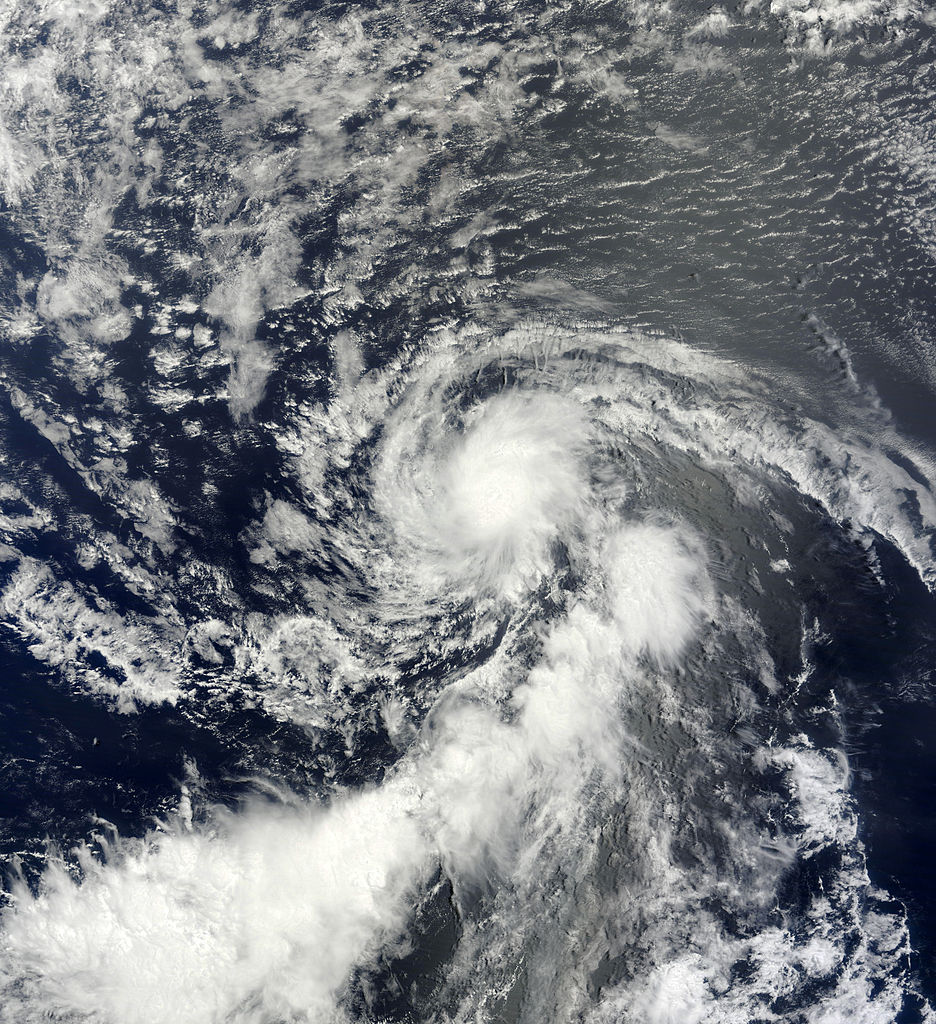
The image above shows Erin shortly after being named. The cyclone achieved only minimal tropical storm status.


A weakness in the subtropical ridge to its north allowed Erin to move northwestward into cooler water and very hostile atmospheric conditions. These conditions promptly dissipated the system.

Thursday, July 25, 2013

Tropical Storm Dorian (2013)

Storm Active: July 24-27, August 3

On July 22, a tropical wave emerged off of the African coast centered around 12°N latitude. The wave was the strongest yet for the 2013 Atlantic hurricane season, and begin to organize almost immediately. By July 23, rotation was evident in the satellite presentation, and convection had become more concentrated about the newly-formed low pressure center. Later that day, the disturbance passed south of the Cape Verde Islands, bringing some scattered showers to the southernmost islands. The definition of the circulation improved further during the evening and thunderstorm activity persisted, so the low was upgraded to Tropical Depression Four early on July 24.

Later that morning, as the system moved west-northwest, it organized further, and strengthened into Tropical Storm Dorian. The storm was entering less favorable conditions, including the slightly cooler water of the central Atlantic and a large dry air mass to the northwest, but the effect of these factors was partially neutralized by a warm, moist air flow that continued into Dorian from the south. Over the next day, therefore, the tropical storm was still able to improve in outflow and convective organization, allowing it to intensify into a strong tropical storm by early on July 25.

Late that day, a large burst of convection flared up, and Dorian even exhibited a clouded eye briefly, reaching its peak intensity of 60 mph winds and a pressure of 999 mb. However, even though the system was now moving into warmer waters, it lost its equatorial inflow of moist air, and the circulation was largely at the mercy of the large dry air mass to its west. This dry air, coupled with moderate shear out of the southwest, disrupted the circulation during the evening of July 25, and Dorian became much less organized. The storm weakened into July 26, and meanwhile continued to race west-northwest, as a ridge to its north steered the shallower circulation faster than it had the previous day, when Dorian had been stronger.

Later that day, Dorian made a turn more toward the west and moved even faster. The circulation became totally exposed that evening as nearly all convection disappeared from the system. It was unclear whether Dorian was still a tropical system overnight, but some thunderstorm activity did redevelop during the early morning hours of July 27, prompting the National Hurricane Center to continue issuing advisories on the weak tropical storm. However, the wind shear had now increased to such a degree that it was eroding the circulation, and it became clear during the afternoon of the same day that Dorian's circulation was no longer closed and that it had degenerated into a tropical wave.

The remnants of Dorain continued west-northwestward and continued to produce gale force winds and convection. However, though a swirl in the clouds was evident, this was not due to a closed surface circulation, but to an upper-level low in association with the system. Thus, despite the fact that the disturbance was no longer a tropical cyclone, the north coasts of Puerto Rico and Hispaniola experienced high surf as the system continued to move west-northwestward. The moisture that had been part of Dorian began to spread over the Bahamas on July 31, and conditions improved as shear lessened. On August 1, more convection appeared and surface pressures fell near the western Bahamas during that day.

By August 2, a trough of low pressure was evident, but the system did not yet have a closed circulation. As the western edge of the system brushed Florida, the remnants of Dorian triggered showers and thunderstorms over various parts of the state. However, the low turned northward that day, navigating around the edge of the Bermuda High. Overnight, despite the fact that upper-level winds were again increasing, a closed circulation appeared, indicating that Dorian had reformed into a tropical depression. By the morning of August 3, convection was displaced well southwest of the center of circulation. But Dorian persisted after its reformation for only 12 hours, reaching only tropical depression intensity and degenerating into a remnant low by the afternoon. The low was absorbed by a frontal boundary the next day.


Dorian was afflicted by dry air for most of its lifetime. The above image shows the western half of the circulation to be partially exposed due to the same dry air, even though Dorian is near its peak intensity.


Before reforming on August 3, Dorian had for a time been only a tropical wave, with no associated low pressure center.

Monday, July 8, 2013

Tropical Storm Chantal (2013)

Storm Active: July 7-10

During the first days of July, a tropical wave moved off of the coast of Africa and tracked rapidly westward. By July 5, concentrated thunderstorms had appeared in a association with a low pressure area at the southern tip of the tropical wave as it moved through the central Atlantic. Initially, development was not anticipated due to the timing: in early July, the central Atlantic does not often support tropical development, partially due to Saharan dry air dominating the region. However, the system remained exceptionally far south, between 5° and 10°N latitude, and it was isolated from the strong shear to its north.

On July 7, satellite data indicated the imminent development of a closed circulation in association with the wave as the low pressure system gained definition. Late that evening, the low was designated Tropical Storm Chantal, as it was observed to have tropical storm force winds. At the time, Chantal was tracking rapidly westward, at speeds in excess of 25 mph, embedded as it was in strong steering winds. During the day of July 8, Chantal's winds steadily increased and its circulation became better defined, but the convective organization remained quite ragged as strong subtropical ridges continued to steer the storm west to west-northwest.

On July 9, showers and thunderstorms began to impact the Windward Islands as the cyclone passed through. Bursts of thunderstorm activity flared up periodically throughout the day, and Chantal continued its trend of modest strengthening, managing to maintain its circulation despite its forward velocity. The system reached its peak intensity of 65 mph winds and a pressure of 1005 mb. However, that evening, increasing westerly shear finally began to take its toll, decoupling the tropical storm's circulation from the surrounding shower activity. By late that evening, nearly all convection had vanished, and the center was nearly impossible to identify.

While it appeared as though Chantal had lost its circulation entirely and degenerated into a tropical wave, rapid development of thunderstorm activity occurred during the morning of July 10 and a poorly defined circulation was found. The system also had made a turn back to the west, indicating a shallow circulation. Indeed, the pressure had risen and Chantal had weakened to a low-end tropical storm. However, heavy rain, mostly displaced to the north and east of the center, swept over much of Hispaniola that afternoon as the storm passed to the south. Finally, additional evidence emerged during the evening of the same day that the circulation had indeed disappeared, and advisories were discontinued as Chantal degenerated into a tropical wave.

A low pressure trough associated with the remnants of Chantal was still producing a large area of thunderstorms on July 11 as it drifted northwestward over eastern Cuba and into the Bahamas. Over the following two days, the disturbance continued to cause rainfall in the Bahamas, and eventually in parts of the U.S. southeast coast, but it did not show any signs of development, and on July 13 merged with a larger system to its north.


The above image shows Chantal, not at peak intensity, but perhaps at peak convective organization before it entered the Caribbean.


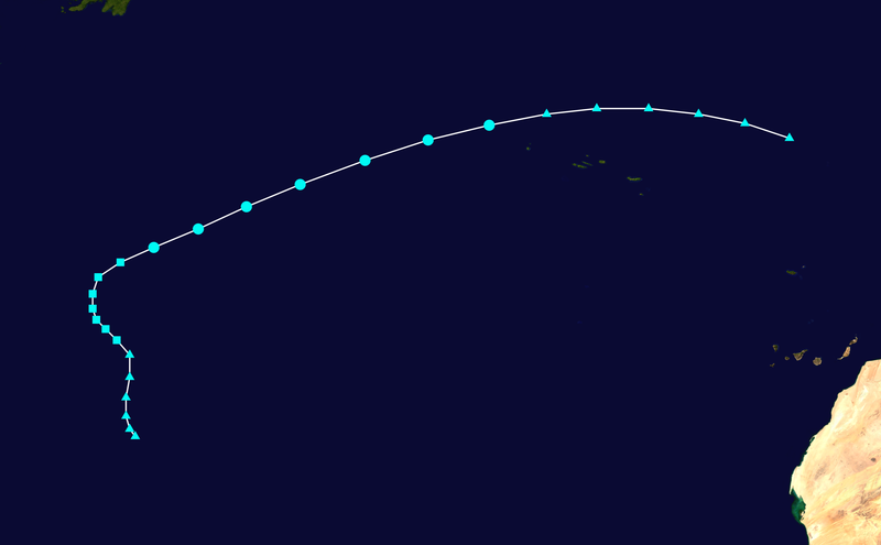
Chantal moved at a blistering pace before dissipating in the Caribbean. The final points on the track (triangles) show its progress as a disturbance over Hispaniola and Cuba, where it caused widespread flooding.

Monday, June 17, 2013

Tropical Storm Barry (2013)

Storm Active: June 17-20

A tropical wave located off the eastern coast of Nicaragua began to show signs of organization on June 15. On June 16, a swirling of clouds became evident on satellite imagery, though a surface circulation had not yet formed and, in any case, the proximity of the developing circulation to central America limited thunderstorm activity.

However, the disturbance emerged into the northwest Caribbean on June 17, and late that morning, a low-level circulation appeared and the system was upgraded to Tropical Depression Two only 60 miles east of the coast of Belize. Later that day, the depression made landfall in Belize at an intensity of 35 mph winds and a pressure of 1008 mb, bringing heavy rainfall to the region.

The depression weakened over land, and lost definition, but the system continued to move west-northwest, and the northern half of the circulation regained convection as the northwestern portion emerged into the Bay of Campeche early on June 18. A ridge situated over the northern Gulf of Mexico weakened slightly that day, allowing the cyclone to shift north slightly in its path. As a result, the center entered the Bay of Campeche during the afternoon of that day, and thunderstorm activity soon recovered near the center.

Though moderate wind shear still affected the depression out of the southwest, the shear began to weaken during the morning of June 19, as the system made a turn westward toward the Mexican coast. This allowed the thunderstorm activity to increase markedly, and the depression was upgraded to Tropical Storm Barry that afternoon. The system continued to gain organization through the early morning of June 20, reaching its peak intensity of 45 mph winds and a pressure of 1003 mb before making its final landfall in Mexico later that morning.

The system quickly weakened over land, becoming a tropical depression that evening, and degenerating into a remnant low late that night. Barry main effect was heavy rainfall; the tropical storm dumped several inches of rain over a large swath of southern Mexico, with localized totals-especially in mountainous regions-exceeding 5 inches.


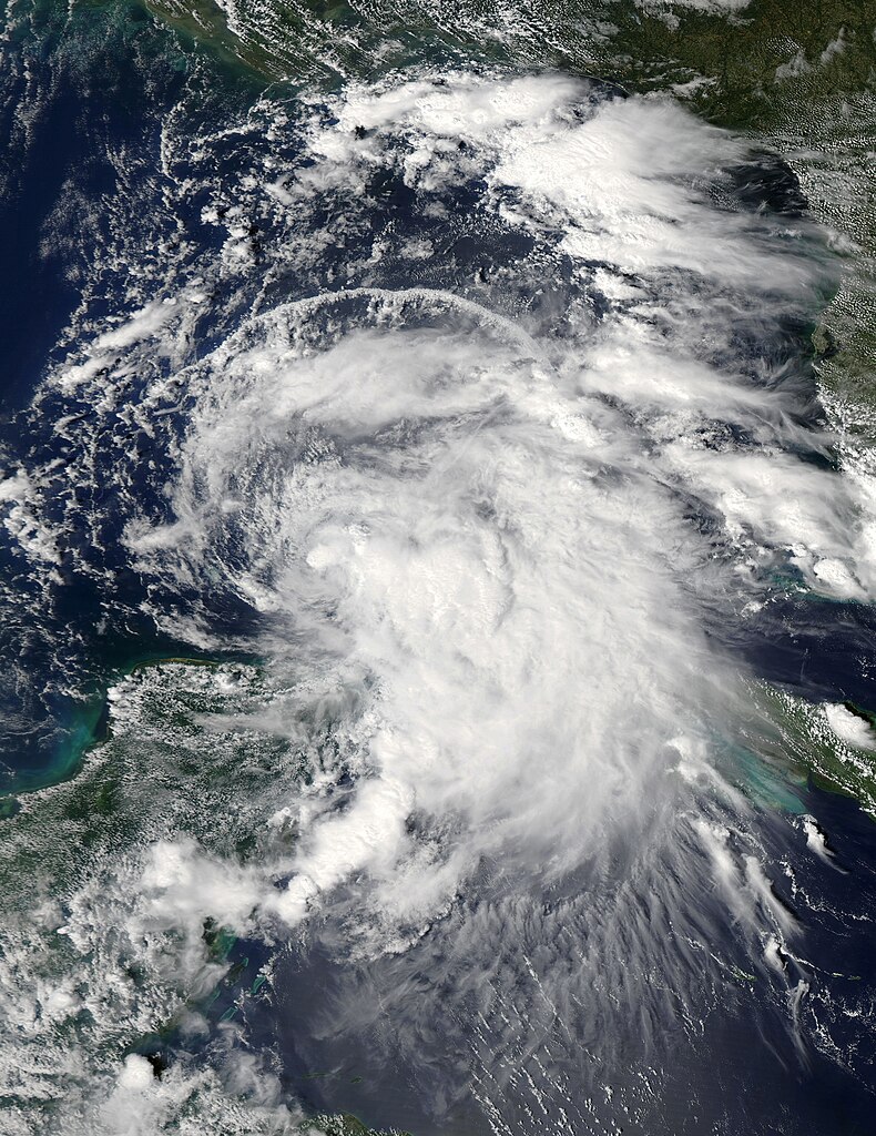
Tropical Storm Barry achieved its peak intensity as a weak tropical storm shortly before its second landfall in Mexico.


A combination of a slow forward speed and extensive moisture from the Bay of Campeche made Barry a significant flooding threat near the end of its life.

Thursday, June 6, 2013

Tropical Storm Andrea (2013)

Storm Active: June 5-7

On June 2, scattered shower activity associated with a trough situated near the eastern coast of the Yucatan Peninsula begin to organize. The system moved north-northwest, and despite only marginally favorable conditions, partially stemming from frontal boundaries moving through the north Gulf of Mexico, developed further. Surface pressures declined near the center of the disturbance during the day of June 4, but the circulation remained broad, and all convection was displaced to the east of the forming center by wind shear in the western Gulf. On June 5, conditions became briefly favorable for formation as the disturbance moved northward, and an aircraft investigating the system found that a well-defined center had formed. The system was therefore named Tropical Storm Andrea, the first tropical cyclone of the 2013 season.

By the early hours of June 6, Andrea was already accelerating north-northeast in the wake of a trough lifting out of the southeast United States. The structure of the cyclone already exhibited some extratropical properties, as its convection was still displaced generally to the north of the center, and a band southeast of the center, reminiscent of a frontal boundary, was forming. Despite this, the circulation deepened and Andrea underwent modest strengthening during that day.

Torrential rains had already begun over Florida and parts of South Carolina that afternoon as the northern bands of Andrea's circulation interacted with a frontal system moving towards the east coast. The system made landfall in northwestern Florida at its peak intensity of 65 mph winds and a pressure of 993 mb at 5:45 pm that evening. The system accelerated considerably and weakened quickly over land overnight as the circulation broadened and dry air invaded the center of circulation early on June 7. By that afternoon, the cyclone was declared post-tropical.

As the cyclone moved northeastward, it caused significant rainfall across the mid-Atlantic and towards New England as the center of circulation stayed near the coastline. The remnants of Andrea dumped a few inches of rain across a large swath of this region in conjunction with the frontal system steering it. By the afternoon of June 8, the cyclone had lifted out of New England.


Tropical Storm Andrea reached peak intensity shortly before making landfall in Florida.


Andrea tracked up the U.S. east coast, largely as a post-tropical cyclone, and brought heavy rainfall to many areas.

Wednesday, May 22, 2013

Professor Quibb's Picks-2013

My personal prediction for the 2013 Atlantic hurricane season is (written May 20, 2013):

18 cyclones attaining tropical depression status
16 cyclones attaining tropical storm status
9 cyclones attaining hurricane status
4 cyclones attaining major hurricane status

These predictions are slightly above normal for an Atlantic hurricane season, particularly in the hurricanes category.

The last decade or so has constituted by far the most active such period in known history for tropical cyclone formation. This may reflect a long-term cycle in Atlantic tropical cyclone activity, known as the Atlantic Multidecadal Oscillation (AMO). The AMO could theoretically explain, for example, the lull in formation in the 1980's and the recent surge in the 2000's.

However, the state of the El Nino is fairly neutral. It is fairly unlikely that a strong El Nino or La Nina event will develop significantly before the conclusion of this year's hurricane season. A neutral state of the ENSO would suggest a fairly average season. This reasoning, coupled with the fact that the Altantic basin is still in a long-term active period, suggests a slightly above above normal hurricane season.

Finally, sea surface temperatures near the U.S., especially near the Gulf Coast, are below normal, and well below where they were in May 2012, partially stemming from a much colder winter and early spring across several areas of the country. Favorable conditions may then be slow to reach areas near the U.S., though this of course does not exclude powerful mid- or late-season storms.

Below, my anticipated risk factors for four major regions of the Atlantic basin are listed. The risk index runs from 1 meaning very low potential to 5 being very high potential.

U.S. East Coast: 3
Though the Bermuda High is still far to the east, near the Azores, small blocking ridges may be frequent in the western Atlantic, so tropical cyclones could very well be steered towards the east coast. Again, such an event is unlikely towards the beginning of the season due to cooler waters and anomalously high wind shear, but the risk near the end of the season is higher.

U.S. Gulf Coast/Northern Mexico: 2
The Gulf of Mexico has not only been anomalously cool, but also the jet stream has dipped well into the U.S. Midwest over the first few months of this year. Such events cause disturbed weather to be frequent, but generally inhibit cyclone formation. As such, the Gulf coasts of U.S. and Mexico are relatively protected, though there is still potential for a sufficiently powerful cyclone to track through the Gulf and make landfall. Also, Florida is at an above average risk, despite the low Gulf index overall.

Yucatan Peninsula and Central America: 3
As usual, the Yucatan and surrounding areas can expect some tropical cyclone activity, particularly in the form of weak systems. The eastern Atlantic is warm and conditions will be favorable for the development of tropical waves before such waves enter the southwestern Caribbean, so stronger storms will almost certainly track to the north.

Caribbean Islands: 5
It has been a few years since a "traditional" Cape Verde hurricane has formed in the east Atlantic and stayed on a westerly path over the Caribbean Islands. However, the likely development of temporary ridges over the tropical Atlantic would push even strong hurricanes on such a path. The strongest cyclones of the season are likely to come over, or pass close to, these islands.

Overall, a slightly above average 2013 season is expected, with particular risk to the Caribbean Islands and the southeast U.S.. Since the climate of the Atlantic region is less volatile than last year, there may be fewer meandering storms such as Hurricane Nadine, and fewer unusual jet stream interactions, such as the one which caused Hurricane Sandy to make landfall in the northeast.

Thursday, May 16, 2013

Hurricane Names List-2013

For the North Atlantic Basin, the hurricane names list for 2013 is as follows:

Andrea (used)
Barry (used)
Chantal (used)
Dorian (used)
Erin (used)
Fernand (used)
Gabrielle (used)
Humberto (used)
Ingrid (used)
Jerry (used)
Karen (used)
Lorenzo (used)
Melissa (used)
Nestor
Olga
Pablo
Rebekah
Sebastien
Tanya
Van
Wendy

This list is the same as that of the 2007 Atlantic Hurricane Season, except for the addition of Dorian, Fernand, and Nestor, to replaced retired hurricanes Dean, Felix, and Noel, respectively.

Tuesday, April 30, 2013

The Arctic and North Atlantic Oscillations

The Arctic Oscillation (AO) and North Atlantic Oscillation (NAO) are two climatological phenomena that characterize the changes in atmospheric pressure over their respective regions, the Arctic, and the North Atlantic.

Based on anomalies in the pressure of the regions from their long-term averages (computed over a period of over 100 years), the oscillations are assigned parameters, called the AO index and NAO index, respectively, which change with time. The sign of the parameter (whether it is positive or negative) can predict certain features of the climate of much of the northern hemisphere, and are particularly important in the winter.

The Arctic Oscillation index is computed from the pressures of the subtropical and subarctic regions. The pressure gradient between the two latitudes determines the sign of the AO index. If pressures are higher in the subtropics than normal and lower in the subarctic, the AO index is positive, and the AO is said to be in its positive phase, while if subtropical pressures are anomalously low and subarctic pressures anomalously high, the AO index is negative, and the AO is said to be in its negative phase.


The above figure shows the general shape of the path of the jet stream during positive and negative phases of the AO. During positive AO, the jet stream tends to be stronger and more linear in its path during the winter, locking cold air in the Arctic regions and generally leading to warmer winters in the subtropical regions. Since the position of the jet stream allows tropical moisture to venture farther north, the subtropics are also generally wetter during these periods.

When the AO index is negative, the jet stream becomes more sinusoidal, with the amplitude of the variations in the jet stream's latitude generally proportional to the magnitude of the negative phase. Where the jet stream dips south, large masses of cold air can engulf regions for days or weeks, generally resulting in colder, snowier winters. At the same time, however, the upswings in the jet stream can bring warm air to generally cold areas. Winters in the northern hemisphere with a negative AO index generally tend to be more volatile.

The NAO is closely related to the AO, except that the index is determined only by the pressure gradient between latitudes only in a very specific region: the North Atlantic near 30°W longitude, or the subtropical region near the Azores Islands, and the Arctic region near Iceland. The effects of the NAO on the jet stream are similar to the AO, but they are not the same. The NAO index is generally a very good indicator of the winter temperature anomaly in the eastern U.S. and Europe, and though its sign usually agrees with that of the AO, this is not always the case:


The graphs of the AO index (top) and the NAO index (bottom) over the winters of roughly the same time period, from the late 1800's to the early 2000's. The indices clearly are related; both are predominantly negative in the period 1960-1980 and predominantly positive from 1980 to 2000, but on some years, they disagree. For example, if the NAO index is positive and the AO index negative, the jet stream may be straight over the Atlantic, bringing warm air to the eastern U.S. and western Europe, but sinusoidal elsewhere. This happened, for example, in the winter of 2011-2012. Conversely, if the NAO index is negative and the AO positive, there may be a large dip in the jet stream over the U.S. and a weak pressure gradient over the Atlantic, but cold air masses may be fairly well confined to the Arctic at other longitudes. This situation occurred in the winter of 2008-2009.

These oscillations, relative to El Nino and La Nina, are notoriously hard to predict. In addition, while the weather of any given winter is influenced by the El Nino/La Nina, the AO, and the NAO, many other factors also come into play. However, the fairly consistent accuracy with which the AO and NAO have predicted the winter weather of North America and Europe serve to exemplify the importance of atmospheric phenomena even in determining the climate of a region thousands of miles away.

Sources: The Winters of Our Discontent from The Scientific American, December 2012, AO and NAO on Wikipedia

Monday, April 15, 2013

More About Constructible Numbers and Figures

This series of posts deals with determining which geometric figures are "constructible", that is, can be formed using only a compass and straightedge.

The set of constructible real numbers, or those numbers whose absolute value is equal to the length of a line segment constructible with compass and straightedge, has already been shown to be of the type called a field. In addition, this field contains all of the rational numbers. But what others, if any, does it contain?

It may be noted that the circle has not featured in any of the constructions thus far. In fact, by use of a circle, one can construct a segment whose length is the (positive) square root of that of a given segment. The construction is illustrated below.


A segment of length a1/2 is constructed by first drawing segments of length 1 and a on end (1). Then, a circle is drawn with the combined segment (of length 1 + a) as a diameter (2). Finally, a perpendicular is erected from the diameter at the point of intersection of the two segments to the circle, and two other segments are drawn connecting the point of intersection of the perpendicular and the circle to the endpoints of the diameter (3). The resulting figure has three triangles, the largest partitioned into the two smaller by the perpendicular. One need only observe that the large triangle is a right triangle, as one of its angles subtends a semicircular arc, and since this large triangle shares a side and an angle with each of the two smaller right triangles, it is similar to each. The two smaller right triangles are then also perpendicular to each other, and so the ratio of 1 to the length of the perpendicular must be equivalent to the ratio of the same length to a. The length of the perpendicular is thus the square root of a.

Thus the field of constructible numbers includes any number that can be derived from a finite sequence of additions, subtractions, multiplications, divisions, and square roots from the unit length 1. In fact, these are all of the constructible numbers. To see this, note first that the construction of segments in the plane involves only the intersections of lines and/or circles. The general equation for a line is ax + by = c, a linear equation, and the general equation for a circle is (x - h)2 + (y - k)2 = r2. It is clear that in solving for the intersection of these two types of functions, the highest degree one could encounter for the intersection points to satisfy is 2, i.e., a quadratic. Finally, by the quadratic formula and the distance formula, which each involve only square roots, the most general type of number one can construct can be seen to be one involving nested square roots, a conclusion in agreement with the previous result.

To illustrate the power of this new concept, we know turn to some applications. First, we relate our result to the geometric construction problems posed at the beginning of this series of posts:

Example 1:
The problem of "squaring the circle" was shown to require the constructibility of the length π1/2. This condition is equivalent to the constructibility of π and is therefore impossible, as π is what is called a transcendental irrational number; there is no polynomial with integer (or rational, by extension) coefficients with π as a root.
Example 2:
"Doubling the cube" was shown to require the constructibility of a segment of length 21/3. This problem is impossible as well, because though there is a polynomial with this number as a root, namely x3 - 2 = 0, this polynomial is of degree 3, not 2, and cannot be factored in any way to reduce its degree. Please note that even though a number such as 21/4 is the root of the degree 4 polynomial x4 - 2 = 0, the substitution y = x2 reduces it to two polynomials of degree 2, and this number is thus constructible.
Example 3: To illustrate the applicability of this concept to figures that actually are constructible, consider the equilateral triangle. Since all three sides are of the same (arbitrary) length, the ability to draw an equilateral triangle depends on its angles, all of which are 60°. To equate the construction of an angle to the construction of a segment, we use trigonometry:


The above figure illustrates that the constructbility of the angle 60° is equivalent to that of the segments of lengths cos(60°) = 1/2 and sin(60°) = 31/2/2. If they are given, a right triangle can be drawn with legs of these lengths, thereby giving the angle. Since 31/2/2 involves only a square root, it is constructible, and 1/2 obviously is. Thus the equilateral triangle can be drawn with compass and straightedge as well.

The problem of constructibility played a greater role in ancient times than it does today. The standards that constitute "existence" for a mathematical object, though still debated, are much looser than in the time of the Ancient Greek mathematicians. For example, we now accept cubic curves, for example, as perfectly reasonable mathematical objects, even though they cannot be constructed with compass and straightedge (in fact, an arbitary point on one of these curves may not be constructible). The problem now mainly serves as a mathematical curiosity, and as an example of how one can calculate the power, in this case the constructing power, of certain systems in mathematics.

Sources: A First Course in Abstract Algebra by John B. Fraleigh, Constructible Number on Wikipedia

Sunday, April 7, 2013

Constructible Numbers and Figures

The problem of constructible figures—determining which geometrical objects can be constructed using only the straightedge and compass—was a longstanding problem of mathematics, resolved in the early 19th century. It is closely related to the famous problems of squaring the circle (constructing a square of equal area to a given circle) doubling the cube (finding a cube with double the volume of a given cube), and trisecting the angle (constructing an angle with measure exactly a third of a given one), and actually encompasses these problems, as we shall see below.

The Ancient Greeks did not merely focus on the problem of determining which figures were constructible to categorize geometric objects—their standards of rigor were such that, if a curve or figure could not be constructed, they did not consider it to exist!

But, as we shall show, the problem of constructible figures can be reduced to determining what length line segments can be constructed. Thus the set of constructible figures is determined by a set of real numbers that corresponds to a set of line segments with these numbers as lengths. To illustrate this concept, we will reduce a few of the problems mentioned above to the problem of constructing a line segment of a given length.


The problem of squaring the circle can be reduced to finding a line segment that is one side of the square, i.e., constructing a line segment of length π1/2. (More precisely, the construction requires the ability to construct a line segment whose length forms a ratio of π1/2 to the radius of the circle. However, assuming the base segment to be of length 1, the problem reduces to the one above)


The problem of doubling the cube is technically in three-dimensions, but it depends on the ability, in plane geometry, to construct a line segment of length 21/3 (again, this is actually the ratio of the side of the larger cube to that of the smaller).

Many other construction problems can similarly be translated into the language of lengths of line segments or ratios of such. Now, the problem is to find what lengths can be constructed. First, we determine what sort of set the set of constructible lengths is. To do this, consider two lengths a and b that are given to be constructible. In other words, if one were forming geometric objects on a piece of paper, one would have, in addition to a compass and straightedge, objects of length a and b from which things can be measured. What other lengths can be obtained from these?


Clearly, given lengths a and b, one can place two lines of these respective lengths end to end, giving a line of length a + b.


Similarly, the length b - a can be constructed from lines of respective lengths a and b. Some care must be taken here, as this construction only yields a positive number for the length of b - a if the length b is greater than the length a. Alternatively, one could consider oriented line segments, or vectors, with initial and terminal points that can be "negative". Here we shall limit ourselves to regular line segments, but allow negative values to be members of the set of constructible lengths. Hence a real number x is a member of the set if its absolute value is the length of a constructible line segment.


Constructing a line segment whose length is the product of two given numbers is a little trickier. In the above figure, we assume a and b to be positive. First, mark a line segment of length a on a given ray, beginning at the endpoint of the ray. Then, draw any other ray out of the endpoint not coincident with the first ray (1). On this second ray, mark two segments beginning from the endpoint of lengths 1 and b. Draw a line segment, l, connecting the the other end of the line segment of length 1 to the end of the segment of length a (2). Finally, draw a line, k, through the end of the segment of length b parallel to l. The intersection of this line with the initial ray demarcates a line segment of length ab from the endpoint. This conclusion follows from the similar triangle law, as the ratio of 1 to a is the same as the ratio of b to ab.


A similar method, again using similar triangles and ratios involving their sides, brings about a segment of length a/b for positive a and b. Begin by marking a line segment of length a along a ray, and draw another ray sharing its endpoint with the first (1). On the second ray, draw a line segment of length b from the endpoint, and connect the opposite end of that segment with that of the segment of length a, forming l (2). Finally, draw the line segment k, beginning at the point on the second ray one unit away from the endpoint (3). The intersection of k with the first ray will define a segment of length a/b, as the ratio of b to a is the same as that of 1 to a/b.

Therefore, given lengths a and b, one can construct a + b, a - b, ab, and a/b. In other words, performing any of these operations on two members of the set of constructible lengths creates another constructible length. The set is said to be closed under these operations. In addition, it is interesting to note that the unit length 1 is needed to compute the product and quotient of lengths. Therefore, we assume all lengths to be in terms of the unit 1, which is also given. Finally, we assume the existence of the length 0, which is simply a point. (It is easy to confirm that the algebraic properties of 0 are satisfied by its geometric counterpart. If one takes b to be 0 in the diagram for division, the line l coincides with the first ray, and the line k, being parallel to l but through a different point, never intersects the first ray. This is consistent with division by zero being undefined.)

A set of this type, closed under addition, subtraction, multiplication, and division, and including 0 and 1, (though division by 0 is undefined) is called a field. Thus the set of constructible real numbers is a field. Any rational function of a and b is a member of this field, where a rational function of a and b is a quotient of polynomials f(a,b)/g(a,b) where both are of finite degree and g(a,b) does not equal 0. Thus the set of constructible real numbers contains all rational numbers, a rather intuitive conclusion. The question of what other numbers the set contains, and its consequences on the motivating problems discussed above, is addressed in the next post, coming April 15.

Sources: History of Mathematical Thought from Ancient to Modern Times, vol. 2, by Morris Kline, A First Course in Abstract Algebra by John B. Fraleigh

Saturday, March 30, 2013

Banach-Tarski Paradox II

This is the second post concerning the Banach-Tarski paradox. For the first, see here.

The Banach-Tarski paradox allows one to, through decomposition and reassembly, turn one three-dimensional ball into two without changing the individual pieces, apparently violating the additivity of volume in Euclidean three-dimensional space. In the previous post, a decomposition of the group F2, roughly the set of finite strings of the symbols "a" and "b", was shown to yield two copies of the same group when the pieces were "translated" in a certain sense.

In carrying over the properties of F2 into three-dimensional space, one treats the symbols a and b as rotations about axes in Euclidean three-dimensional space. Traditionally, the axes are considered to be the x- and z-axes of Cartesian coordinates. In fact, the necessity of a choice of axes is why a paradoxical decomposition can only occur in dimensions of three and above, and not in two. This is because, in F2, the strings ab and ba are distinct; following their respective paths on the Cayley graph yields two different points. In two dimensions, any two rotations about the origin are commutative, i.e. can be performed in either order with the same result. Since the noncommutativity of F2 cannot be carried over into two-dimensional space, the paradox is not possible there.

The rotations that correspond to a and b are taken to move through an angle of the inverse cosine of 1/3, or about 70.5°. This exact angle choice is unnecessary, but the angles chosen for a and b must be irrational multiples of a right angle. This is because no two linear combinations of them can be allowed to yield the same rotation; all linear combinations of the angles must be distinct. The purpose of this condition is to mimic a property of the group F2, namely that no two distinct simplified strings represent the same element, or, in other words, no two distinct paths (without retracing) lead to the same point on the Cayley graph.

Next, we briefly restrict our attention to the sphere (which, unlike the ball, does not include the interior area; the sphere is as the surface of the earth and the ball like the surface as well as the interior). The set F2, which we shall now consider a group of rotations, can act on any point p of the sphere. The set of points thus obtained, following any sequence of rotations (each corresponding to an element of F2) beginning at p, is called the orbit of p.

In this way, the entire surface of the sphere can be partitioned into an infinite set of these orbits, none of which overlap. Since a set of finite sequences is countable, F2 is as well. Since the number of points on the sphere is uncountably infinite, it follows that there are uncountably many of these orbits. Here the axiom of choice is invoked to select a single point from each orbit, and collect these into another set M.

The details involved in explicitly applying the decomposition of the sphere are too technical to consider here; the above steps were included to illustrate the use of the axiom of choice. The next step essentially brings about the paradoxical decomposition of the sphere by shifting M by the rotations a and b. Two copies of the sphere arise in a manner similar to that of F2.

Finally, the result is extended to the three-dimensional ball by performing the decomposition on a continuum of spheres of radii 0<r<R, where R is the original radius of the ball being considered. Each point p on the outer sphere can be paired to a point on any of the smaller spheres by projecting inward along the ray from p to the origin (see below). Clearly the union of all these spheres contains all the points of the ball, with the exception of the origin, O.


The final obstacle, therefore, is proving that the ball with its center removed can be decomposed and reassembled to form the entire ball. In fact, there are subtle difficulties in doing this that do not concern us here. Once this is done, the Banach-Tarski theorem is proven.

Following this technical formulation, it is enlightening to step back and consider the implications of the paradox. It is important to see that the decomposition above could not be applied to a physical object. The above procedure depends on the infinite divisibility of the ball, which an object composed of matter does not possess. Additionally, the pieces in the decomposition, though finite in number, are not "chunks" of the ball but infinite collections of points, and so are not physically continuous.

Though inapplicable to the physical world, the Banach-Tarski paradox helps to elucidate the fundamental differences between mathematical and physical space, and the wide-reaching consequences of assuming statements such as the axiom of choice.

In response to this and similar paradoxes that follow from the axiom of choice, there have been attempts to appropriately weaken the axiom of choice to an axiom which, though giving most of the same benefits, eliminates the paradoxes. One of these is called the axiom of countable choice, which limits the applicability of the axiom to countable sets. This avoids the Banach-Tarski paradox, but some set theoretical results are lost. In addition, the rather arbitrary restriction to countable sets seems inelegant, as it complicates the axiom, bringing in more concepts.

Also, some interesting work has been done since the Banach-Tarski paradox was published in 1924 that has extended the result. First, the final step of the proof above, in its original form, involved a total of 24 pieces. Through an alteration of the orbit scheme above, the number of pieces can be reduced to five.

Furthermore, the beginning and ending sets can be more general than simply a ball and two balls. Clearly, by a repetition of the above process, any (finite) number of balls can be produced by decomposition. It has even been shown that, if the original ball can be decomposed into an infinite number of pieces, one can obtain infinitely many copies of the ball, and even uncountably many. By allowing these decompositions, we can simply conjure up as many balls as we want from a single one!

In fact, the statement has been generalized even further to allow any bounded three-dimensional regions which are not "empty" to be broken up into a finite number of pieces and reassembled into any other of these regions.

The Banach-Tarski paradox is central in proving that there is no finitely additive measure in three-dimensional (and higher) spaces which agrees with the basic conception of volume. In one and two dimensions, there still is no countably additive measure that can be universally applied due to the existence of non-measurable sets (see again the Lebesgue measure series for an example of a measure in mathematics). The above are a few of the surprising geometric applications of the axiom of choice, showing how pervasive this assumption is, even beyond its native set theory.
Sources: http://www.math.hmc.edu/~su/papers.dir/banachtarski.pdf, http://www.bsu.edu/libraries/virtualpress/mathexchange/05-01/Coleman.pdf, Banach-Tarski Paradox at Wikipedia

Friday, March 22, 2013

Banach-Tarski Paradox

The Banach-Tarski paradox is a very counterintuitive theorem in geometry that, in effect, states that a three-dimensional ball can be broken up and reassembled in such a way that two identical balls of the same size as the first are formed. This "doubling" of the ball seems contrary to the usual ideas of Euclidean geometry, and is therefore exemplifies the controversy over its underlying assumption, the axiom of choice.

The axiom of choice is one of the most debated topics in mathematics. It is an axiom of set theory, and the debate is whether it is right to assume it, and in what "strength" or version. The axiom itself, put informally, runs thus:

From any collection of nonempty sets, there exists a way to choose exactly one member from each set.

The ability to make such choice seems intuitive enough, but as seen elsewhere on this blog, the assumption of the axiom of choice implies the existence of sets that have no "volume", i.e. their size cannot be measured in any way. And this, as we shall see, is a crucial concept needed to derive the Banach-Tarski paradox.

The "translation" of the paradox into set theoretical concepts involves treating the three-dimensional ball as a set, call it A. We consider a division of the ball as a partition of the set A into the subsets A1, A2,...,An, where none of the subsets overlap, or in set notation, where AiAj = Ø whenever ij (i and j run from 1 to n). In this decomposition, n is finite, and only a finite number of pieces are needed to transform one ball into two. This in itself makes the paradox even more unbelievable.

After the ball is partitioned, each piece would then undergo a translation (some movement in space) and a rotation, taking each subset Ai to a corresponding Bi. In this translation, the intrinsic properties of the subsets are not altered; they are simply rearranged in space. The resulting sets, B1,...,Bn, can be split into two groups in such a way that B1B2∪...∪Bm is a ball congruent to the first, and the union of remaining subsets, Bm + 1∪...∪Bn, is another ball also congruent to the original one. The transformation is illustrated below:


Since Euclidean translations and rotations preserve volume, the Banach-Tarski paradox violates the principle of the additivity of volume, i.e., that the sum of the volumes of two disjoint sets is the volume of their unions. The beginning ball and the (union of) two equivalent balls are composed of the same (translated) pieces, but they have different volumes. The reason this principle is violated is that the sets in question are non-measurable, or cannot be assigned a volume by any measure. Therefore, the idea of volume additivity has no meaning for them. Non-measurable sets, in addition, can only be proved to exist with the axiom of choice or an equivalent statement. We shall assume the existence of these non-measurable sets, but a construction of such a set under the Lebesgue measure can be found here.

The proof of the Banach-Tarski paradox at first does not work directly with the ball, but instead deals with a more abstract group of points. As we shall see, the decomposition of this abstract set can be performed analogously on the ball with slight modifications.

The abstract set in question is called the free group of two generators, or F2, and it refers, in effect, to the set of strings of the symbols a and b, as well as their inverses, a-1 and b-1. For example, the strings aba-1b and bba-1baa are members of F2. We also define e, or the empty string, as the string in F2 with no members. Finally, we define an operation, *, on strings in F2 that combines two strings into one by placing the second directly after the first. Therefore ab-1*b-1aab = ab-1b-1aab. Additionally, strings are simplified by two rules, where x stands for any string in F2:
  1. ex = xe = x
  2. aa-1 = a-1a = bb-1 = b-1b = e
As an example of the above rules, consider the product (under the operation *) of the strings a-1bab and b-1a-1bab-1.

a-1bab*b-1a-1bab-1 = a-1babb-1a-1bab-1 = a-1baea-1bab-1 = a-1baa-1bab-1 = a-1bebab-1 = a-1bbab-1

The group F2 can be visualized in several ways. One is as an infinite "tree" of elements, where points on the tree represent strings and "branches" describe the construction of these strings. Below is one example of such a visualization.


A tree of this type is called a Cayley graph of the group F2. Illustrated are the strings of F2 up to three symbols in length. The segments connecting the strings (black dots) illustrate the addition of a symbol to the right of the existing string. One begins in the center with e, the empty string, and moves right to add an "a" and up to add a "b". Moving oppositely to either of the above directions appends an inverse of the corresponding symbol. Note that tracing a path and then retracing backward produces a symbol adjacent to its inverse, causing cancellation. The construction of the string ba-1b-1 is illustrated; staring at e, one first proceeds upward, then left, then down. The reader can verify this construction.

The decomposition of F2 requires the use of some new notation. By S(a) denote the set of all strings in F2 beginning with the symbol a. Define the expression similarly in the case that a-1, b, and b-1, respectively, are substituted for a. Next, the notation, aS(a-1), for example, refers to the set of strings produced by joining the string "a", with a member of the set S(a-1). Thus there is a string in aS(a) for every string in S(a). It must be made clear, however, that the set S(a) and the other related sets contain only simplified strings. Nowhere in any string in S(a) will there appear a term "aa-1" or "bb-1", as these will have already been cancelled.

Armed with these notions, we can construct the "paradoxical" decomposition of F2. The first step is a simple decomposition involving separating the group into each of four disjoint quadrants, the sets S(a), S(a-1), S(b), and S(b-1), and the set {e}, consisting only of the empty string.

The next operation required is a "shift" of the set S(a-1) by the element a into the set aS(a-1), which, as discussed above, has as members every string obtained by adjoining a, (through the operation *) on the left, to some member of S(a-1). The significance of this shift in relation to the sphere will be apparent later. This shifted set is interesting because, when a is combined with a string beginning with a-1, the two elements cancel. Since, in S(a-1), the second and subsequent symbols of each member are arbitrary, every string beginning with a-1, b, or b-1 is a member of aS(a-1). For example, the string bab-1 is the same as a combined with a-1bab-1, a member of S(a-1). Also, strings beginning with a-1 such as a-1bb can be formed as the combination of a and a suitable string beginning with "a-1a-1", in this case a-1a-1bb. Finally, since a-1 is obviously a member of S(a-1), the string aa-1 = e is therefore a member of aS(a-1). In fact, the only strings that are not included in aS(a-1) (ironically) are those beginning with a! This is because, for this to occur, the second element of a member of S(a-1) would have to be a, and this cannot occur, as all strings in S(a-1) are assumed to be simplified.


The above is another view of the Cayley graph, this time illustrating the quadrant S(a-1) along with the shifted set aS(a-1). The only strings not members of the latter set belong to S(a). Therefore, the group F2 is a union of aS(a-1) and S(a). A similar procedure, substituting b for a, leads to the conclusion that the union of bS(b-1) and S(b) is again F2. In summary,

F2 = {e}∪S(a)∪S(a-1)∪ S(b)∪S(b-1) = aS(a-1)∪S(a) = bS(b-1)∪S(b).

The sets S(a-1) and S(b-1) from the original have been shifted by a and b, respectively, and been incorporated into two other decompositions of the same group F2. One copy of F2 has been made into two. (One might well wonder "what happened to {e}?" It turns out that this piece is simply discarded in the above procedure, but the scheme is modified slightly in application to the ball to correct this subtlety).

The relation between F2 and the three-dimensional ball, as well as other extensions of the paradox, are found in another post.

Sources: http://www.kuro5hin.org/story/2003/5/23/134430/275, Banach-Tarski Paradox on Wikipedia