On June 23, a tropical wave moved over the tropical Atlantic from the western coast of Africa. The wave encountered unusually warm water and moist air for June, which allowed it to gradually develop as it moved fairly quickly westward at 15-20 mph. By June 27, a broad low pressure center had formed and a nascent circulation was evident on satellite imagery. Convection increased near the center the next day and the system was designated Tropical Depression Two. This marked the easternmost June formation of an Atlantic tropical cyclone in over 20 years.
Later that evening, the depression was upgraded to Tropical Storm Beryl. From that point, Beryl underwent rapid intensification for the next few days, exhibiting the textbook evolution of a strengthening tropical cyclone. At first an amorphous blob of thunderstorms, Beryl developed pronounced spiral bands fanning out west of the circulation center early on the 29th. By that afternoon, a central dense overcast covered the center and the system began building an eyewall. Beryl was upgraded to a hurricane that evening. To that point, conditions near the storm were quick favorable to intensification with the exception of some wind shear from the east. However, since the shear vector pointed the same direction as the storm's motion, it had less of an effect than it otherwise would. Even the shear diminished by early on June 30, however. Beryl's burst of strengthening continued and it became the first major hurricane of the 2024 Atlantic hurricane season that morning as an eye emerged on satellite. At the time it reached category 3, it was located at 10.6° N, which was farther south than any major hurricane had ever been observed in the Atlantic, with the lone exception of Hurricane Ivan in 2004, which did the same at 10.2° N.
The eye cleared out further over the next few hours and Beryl reached category 4 strength, with peak winds of 130 mph. Beryl was the first Atlantic hurricane ever recorded to reach category 4 intensity in June; the previous earliest category 4 in a season was Hurricane Dennis of 2005, which reached that intensity on July 8. By that time, the storm was approaching the Windward islands, still moving at a fairly rapid clip just north of west. The eye contracted and clouded over during the night as the core of Beryl underwent an eyewall replacement cycle. This reduced the maximum winds back to category 3 intensity but broadened the windfield. A new larger eye cleared out during the morning of July 1 and the storm resumed intensification, regaining category 4 strength. That morning, Beryl made a direct landfall in the island of Carriacou, part of the Grenadine island chain in the Windward Islands, with maximum sustained winds of 150 mph and a minimum pressure of 950 mb. The cyclone was the first known major hurricane to directly hit any of the Grenadine Islands.
Beryl continued quickly toward the west-northwest and entered the Caribbean sea that afternoon. Ocean heat content was even higher in this region, and atmospheric conditions remained favorable, so the storm deepened even further as it left the Windward Islands behind. That night, it reached category 5. Beryl eclipsed Hurricane Emily of 2005 to become the earliest category 5 on record (Emily reached this category on July 16), and was only the second recorded category 5 in July. The hurricane reached its peak intensity of 165 mph winds and a pressure of 934 mb early in the morning on July 2. After that, wind shear began to increase, disrupting Beryl. Throughout the day, the circulation became somewhat tilted toward the northeast with height and the eye lost definition until it became cloud-filled; the satellite presentation also became much less symmetric. Despite all this, the system weakened only slowly: it was reduced to category 4 during the afternoon of July 2, but maintained category 4 intensity through July 3.
Beryl's center passed just south of Jamaica during the day, but close enough that the northern eyewall crossed the coastal areas of the southwestern portion of the island. The northern eyewall had the strongest winds, so the impacts were fairly severe despite the lack of an official landfall. This land interaction and still increasing shear brought the system down to category 3 intensity overnight, but the inner core was surprisingly resilient, with at least the northern eyewall remaining intact into July 4. That morning, the storm passed south of Grand Cayman of the Cayman Islands, still a major hurricane; the center was a little further away, so the island was not affected as much as Jamaica.
The storm diminished to a category 2 that afternoon, but unexpectedly halted its weakening trend and fluctuated in strength later that day. Its continued west-northwesterly motion brought it toward the Yucatan Peninsula overnight and Beryl made landfall near Tulum as a category 2 during the morning of July 5. Fortunately, the storm started weakening again immediately prior to landfall and the windfield contracted some, limiting impacts. The cyclone's passage over the Yucatan Peninsula finally damaged it more significantly: the vortex became tilted with height and all deep convection was gone from the center by the time it emerged into the Gulf of Mexico that evening. At that time, Beryl's winds had fallen to tropical storm force. The Gulf waters, particularly immediately northwest of Yucatan, did not have as much heat content as the Caribbean Beryl had just left; further, some dry air from the southwest had been entrained into the circulation. Therefore, even once over water it took time for the system to recuperate. Strong thunderstorm activity only began to return in earnest around 12 hours after it emerged over water, during the morning of July 6.
Beryl began to feel the influence of a trough of low pressure over the central United States and it curved toward the northwest that day. The storm's battle with dry air greatly slowed intensification, though some deepening began on July 7. That night, the system approached the Texas coastline, but found more favorable conditions in its last hours over water. Beryl regained hurricane intensity and made landfall in Texas early on July 8th with peak sustained winds of 80 mph and a minimum central pressure of 979 mb. Though the cyclone was only a category 1, the curvature of the Texas coastline amplified storm surge impacts, and the storm held its own a fair way inland, bringing hurricane force winds to the Houston area.
Beryl gradually weakened as it pushed farther inland on the 8th and curved toward the northeast. The cyclone diminished to a tropical storm late that morning and a tropical depression that evening. Beryl accelerated northeastward until it became post-tropical the morning of July 9 while centered over Arkansas. Its remnants continued to bringing heavy rains across the central United States over the next few days.
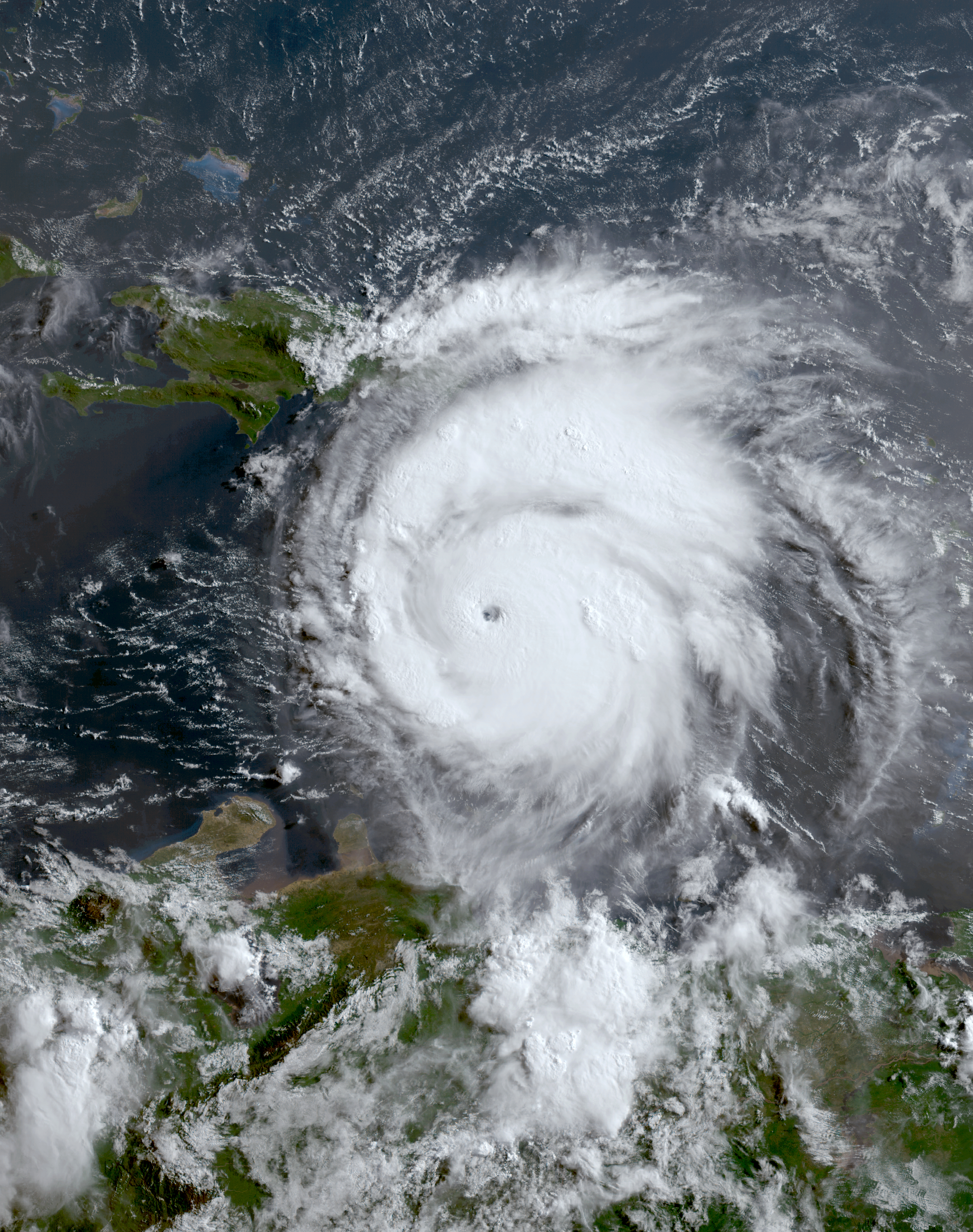
The image above shows Beryl at peak intensity during the morning of July 2 as a category 5 hurricane. Beryl's strength was unprecedented for any hurricane ever recorded so early in Atlantic hurricane season.

Beryl had severe impacts all along its path, including the Windward Islands, Jamaica, the Yucatan peninsula, and Texas.

