Pages

Tuesday, December 17, 2019

2019 Season Summary

The 2019 Atlantic hurricane season had above-average activity, with a total of

20 cyclones attaining tropical depression status,
18 cyclones attaining tropical storm status,
6 cyclones attaining hurricane status, and
3 cyclones attaining major hurricane status.

Before the beginning of the season, I predicted that there would be

15 cyclones attaining tropical depression status,
14 cyclones attaining tropical storm status,
6 cyclones attaining hurricane status, and
3 cyclones attaining major hurricane status.


The average number of named storms, hurricanes, and major hurricanes for an Atlantic hurricane season (over the 30-year period 1981-2010) are 12.1, 6.4, and 2.7, respectively. The 2019 season was much above average in the number of tropical storms (in fact, it was only the sixth year since the advent of the modern naming system that the "S" name was used), but near average in the hurricane and major hurricane categories. This stemmed in part from the fact that the season featured many short-lived, weak tropical storms and a few powerful hurricanes. The ACE value for the 2019 season (which accounts for duration and intensity of storms as well as number) was around 130, just above the average. Apart from the addition of a few extra short-lived cyclones, my predictions were on target.

The El Niño event initially forecast to continue (see the first image in this post) through the 2019 summer/fall died out by July, transitioning to an ENSO neutral/slightly positive state that continued through November. Since an El Niño event typically suppresses hurricane activity, this factor alone would suggest an average to slightly below average season. Indeed, 2019 did display some of the hallmarks of an El Niño season, including storm tracks curving away from the north American mainland and wind shear in the main development region (the Caribbean and tropical western Atlantic). However, the "tropical wave train" off of Africa was quite vigorous for most of the season, and even extended later than usual into October (with Tropical Depression Fifteen among the latest forming tropical waves off of Africa ever recorded). Also offsetting the residual El Niño was the continuing ocean warmth of the subtropical Atlantic, which contributed to prolific development; nearly half of the season's storms formed in the subtropical Atlantic.

The most damaging storms of the 2019 season were Hurricane Dorian and Tropical Storm Imelda. Dorian devastated the Bahamas, especially Abacos Island and Grand Bahama, as a category 5 hurricane. It was the strongest landfalling storm on record for the region and was tied for the most intense landfalling hurricane by windspeed ever recorded in the Atlantic (with the Labor Day hurricane of 1935). Imelda was only a tropical storm, but its slow motion over southeast Texas caused a major flooding event similar to, though slightly less severe than, those associated with Harvey and Florence in the previous two years. Some other notable facts and records from the 2019 season include:
  • Seven of the eighteen named storms of the 2019 season lasted less than 24 hours, a new record
  • Subtropical Storm Andrea formed on May 20, marking the fifth consecutive year in which a named storm developed before the official start of the season on June 1 (also a new record)
  • Dorian was the strongest Atlantic hurricane ever recorded so far north at its latitude of peak intensity, 26.6° N
  • When Lorenzo became a category 5 hurricane, it marked only the seventh time on record that multiple category 5 hurricanes were recorded in a season; Lorenzo was the easternmost forming category 5 on record
  • Pablo strengthened into a hurricane farther north and east than any cyclone previously observed, at 42.8° N, 18.3° W, only a few hundred miles west of the coast of Spain
Overall, the 2019 season was somewhat above average (though near average in number of hurricanes and major hurricanes), with Hurricane Dorian the strongest and most damaging.

Tuesday, November 19, 2019

Tropical Storm Sebastien (2019)

Storm Active: November 19-24

Around November 15, a trough of low pressure formed over the central Atlantic, generating a diffuse area of shower activity well to the east-northeast of the Lesser Antilles. The system moved steadily northwestward over the next few days and developed a weak low pressure center on November 17. Convective activity concentrated some near the center soon after, though upper-level winds and dry air out of the west confined most thunderstorm activity to the disturbance’s eastern side. During the morning of November 19, satellite data indicated a closed circulation was present and the low was upgraded to Tropical Storm Sebastien.

The next day, the cyclone turned northward as it rounded the edge of a subtropical ridge and began to feel the influence of an approaching front from the west. Sebastien faced heavy shear but still managed to strengthen some due to favorable upper-level divergence. That day, it continued its turn to the northeast, accelerating some as it did so. Convection was rather disorganized, but the system maintained its identity as it moved ahead of the advancing frontal boundary.

By November 22, Sebastien was beginning to exhibit some extratropical characteristics, but its inner core was still clearly that of a tropical system as it sped up even further. Under the cyclone, ocean heat content rapidly diminished, but it did not weaken, and in fact reached its peak intensity of 65 mph winds and a pressure of 994 mb the next day. Sebastien was already bringing heavy surf and high winds to the Azores by this time, and it rocketed across the westernmost islands during the evening of November 24. At last, its quick forward speed, coupled with cold ocean waters and frontal interaction, caused the storm to fully transition to extratropical later that night. The remnants of Sebastien merged with another system near Ireland a little over a day later.

The above image shows Tropical Storm Sebastien on November 24 shortly before extratropical transition.
The track and evolution of Sebastien were not well anticipated by computer models. While the general recurvature was agreed upon, initial model runs did not indicate Sebastien would remain tropical for as long as it did, nor that it would be able to maintain strong tropical storm intensity.

Friday, November 1, 2019

Subtropical Storm Rebekah (2019)

Storm Active: October 30-November 1

During the last week of October, another nontropical low over the northern Atlantic slowed to a stop west of the Azores islands. The powerful low weakened some as it drifted generally southeastward over the next couple of days, but it moved over slightly warmer water. By October 30, the low had enough thunderstorm activity to be classified Subtropical Storm Rebekah. Though convection was concentrated in a band wrapping halfway around the center, the center was located under an upper-level low, an indicator of subtropical characteristics. The cyclone moved eastward at a good clip over the next day and changed little in intensity. On October 31, conditions near Rebekah degraded as it encountered cooler waters and strong upper-level winds. Deep convection vanished by that evening, and the storm became post-tropical early on November 1. By this time, the remnants were nearing the Azores, but impacts on the islands were minimal.

Lacking deep convection and colocated with an upper-level low, Rebekah was classified as a subtropical storm.
The above image shows the meandering track of Rebekah over the northern Atlantic. Square points represent times at which Rebekah was subtropical.

Saturday, October 26, 2019

Hurricane Pablo (2019)

Storm Active: October 25-28

On October 23, a non-tropical low centered several hundred miles west of the Azores began to deepen and produced strong winds and scattered rains over a large area of the northeast Atlantic. The low moved generally east-southeastward over the following days. On October 25, a small pocket of deep convection formed about the center of circulation. That afternoon, the system became Tropical Storm Pablo, a very small tropical storm in the middle of what appeared on a larger scale as an extratropical cyclone. Pablo was named at the same time as Tropical Storm Olga in the Gulf of Mexico, a new record for the latest in a season that two storms were named simultaneously. Though ocean temperatures were below the ordinary threshold for tropical cyclone development, a cool upper atmosphere gave the system enough instability to support tropical development.

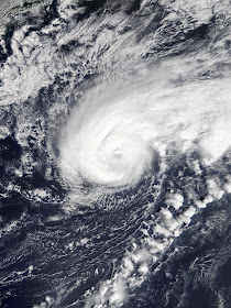
Upon formation, the tiny Pablo had an even tinier eye feature on satellite imagery. Gale force winds associated with the tropical cyclone extended only a few dozen miles from the center, even though the parent extratropical system still was generating comparable winds in its much bigger northwest quadrant. On October 26, Pablo turned east and then northeast, strengthening a bit as it did so. Early that evening, the center passed close to the easternmost Azores islands, bringing additional rain, strong winds, and high waves. Defying expectations, the cyclone intensified further as the eye became better defined. During the morning on October 27, Pablo achieved hurricane status. At 42.8° N, 18.3° W, this was the furthest northeast any hurricane had ever formed on record. Pablo reached its peak intensity of 80 mph winds and a central pressure of 977 mb a few hours later. Meanwhile, the storm turned back toward the north and slowed down somewhat.

Soon after, even colder waters along Pablo's track at last caused convection to degrade. The small system suffered a rapid demise overnight, weakening to a low-end tropical storm and then becoming post-tropical early on October 28 when it degenerated into a swirl of low clouds. The remnant low drifted slowly northwest before it was absorbed by another low pressure system.


The above image shows Pablo near hurricane strength on October 27.

Pablo became a hurricane farther to the northeast than any previous cyclone on record.

Friday, October 25, 2019

Tropical Storm Olga (2019)

Storm Active: October 25

During the latter part of October, a tropical wave moved across the Caribbean and toward central America. As it passed near Belize around October 22, it began to exhibit disorganized thunderstorm activity. The system moved west-northwestward over the following days but did not develop further until emerging into the Bay of Campeche. On October 24, a circulation began to spin up in earnest over water west of the Yucatan Peninsula and convection increased markedly. Already, a autumn cold front approaching from the northwest was beginning to interact with the developing low. Nevertheless, it managed to become Tropical Depression Seventeen during the morning of October 25.

A few hours later it strengthened into Tropical Storm Olga. The front accelerated the newly formed Olga north-northeast that afternoon and its circulation elongated. Aircraft data collected during the evening suggested that the center had become embedded within the frontal boundary, and that a clear temperature gradient existed across the two sides of the circulation separated by the front axis. Thus, Olga was deemed post-tropical, only 12 hours after initially becoming a tropical cyclone. That night, ex-Olga made landfall in Louisiana. The combined system brought very heavy rain and widespread wind gusts to gale force, with some reaching 70 mph. Olga's tropical moisture drove up rain totals with the storm for the next few days as it pushed eastward.


The above image shows Tropical Storm Olga on October 25 interacting with the front.


Just like Nestor before it, Olga was a short-lived tropical cyclone in the Gulf of Mexico whose primary impacts occurred after merging with a front.

Saturday, October 19, 2019

Tropical Storm Nestor (2019)

Storm Active: October 18-19

Around October 12, a large low pressure area formed over the southwestern Caribbean sea. The system moved slowly northwest over the following days but land interaction with central America stifled any chance at development initially. It emerged into the Bay of Campeche on October 16 and began a gradual turn toward the northeast. The disturbance deepened over water, but it also began to interact with a trough of low pressure to its northeast across the northern Gulf of Mexico. This interaction spawned a cyclone with some tropical characteristics, but which was also highly asymmetrical. The pull of the front also caused the system to accelerate northeastward. Finally, during the afternoon of October 18, the cyclone began sufficiently tropical to be classified Tropical Storm Nestor.

Though rather disorganized and not resembling a classical tropical cyclone, Nestor gained a boost in strength from the nearby trough, pushing it to its peak intensity of 60 mph winds and a pressure of 996 mb late that evening. By this time, the storm was approaching the panhandle of Florida, already bringing rain and gale force wind gusts. Nestor lost its tropical characteristics the morning of October 19 as convection retreated well to the east of the circulation and became post-tropical. The post-tropical storm made landfall a few hours later. Soon after, it crossed the U.S. southeast and exited toward the open Atlantic waters.


The above shows the disorganized Nestor shortly after classification as a tropical cyclone.


Nestor's remnants spawned a few tornadoes over the U.S. southeast as the system passed through.

Wednesday, October 16, 2019

Tropical Depression Fifteen (2019)

Storm Active: October 14-16

On October 13, a large tropical wave emerged into the Atlantic, exiting western Africa. Ordinarily, tropical waves do not organize so far east by mid-October, but unusually warm waters and low wind shear allowed the disturbance to consolidate. During the afternoon of October 14, the wave developed into Tropical Depression Fifteen. The formation took place southeast of the Cabo Verde islands, making the depression one of the easternmost forming tropical cyclone ever observed so late in the year. It tracked northwest over the following day but changed little in organization. Having a very broad circulation, Fifteen struggled to develop deep convection. However, this did not prevent the cyclone from bringing locally heavy rains and gusty winds to the Cabo Verde islands on the 15th. The system's circulation became elongated soon after as atmospheric conditions began to deteriorate. Fifteen dissipated during the morning of October 16.


The above image shows Tropical Depression Fifteen near the coastline of West Africa.


Though very short-lived, Fifteen was notable for forming so close to Africa exceptionally late in the calendar year.

Friday, October 11, 2019

Tropical Storm Melissa (2019)

Storm Active: October 11-14

On October 8, a non-tropical low pressure center formed along the western edge of a dissipating frontal boundary situated west-southwest to east-northeast across the western Atlantic ocean. When the low formed, it was located a few hundred miles off the North Carolina coastline. It moved north-northeastward over the next few days, deepened some, and absorbed another disturbance approaching from the south. Steering currents collapsed on October 10 and the system became almost stationary east of the mid-Atlantic coastline. Even as a non-tropical system, it brought dangerous ocean conditions and strong winds to the coastline, especially southern New England. There was not much in the way of rainfall associated with the low at first, but convection increased in a curved band north of the center early on October 11. Shortly afterward, the disturbance was classified Subtropical Storm Melissa, already with maximum winds of 65 mph and a central pressure of 995 mb.

That day, the cyclone drifted slowly southward, but soon westerly flow steered Melissa east and caused it to accelerate some away from the U.S. coastline. The structure changed some by October 12, with convection moving closer to the center of circulation. The structural change necessitated a reclassification of Melissa as a tropical storm. As the cyclone moved east, it encountered more hostile atmospheric conditions, which stripped away most of the thunderstorm activity. Melissa weakened into October 13. These trends continued until the cyclone became extratropical on October 14.


The above image shows Melissa after transitioning to a tropical storm on October 12. During this transition, the windfield contracted significantly, leaving a small area of central convection


Melissa formed near the east coast but moved away without affecting land.

Monday, September 23, 2019

Hurricane Lorenzo (2019)

Storm Active: September 22-October 2

On September 22, a vigorous tropical wave over Africa emerged into the far east Atlantic. Immediately, it showed signs of organization, and was classified Tropical Depression Thirteen that night while located southeast of the Cabo Verde Islands. The next day, it developed spiral bands and steadily strengthened, earning the name Tropical Storm Lorenzo that afternoon. Upper-level winds, sea surface temperatures, and humidity were all in Lorenzo's favor as it continued to intensify. The cyclone turned west-northwest on September 24 as it followed the boundary of a mid-level ridge. Later that day, Lorenzo achieved hurricane status. The cyclone was also quite a large hurricane, with tropical storm force winds extending over 200 miles from the center of circulation.

On September 25, an eye feature began to form on satellite imagery. This led to more rapid strengthening shortly thereafter. Lorenzo was able to overcome a small dry air intrusion and stabilize its eyewall overnight. By mid-morning on the 26th, it had rocketed to major hurricane strength, becoming the 3rd of the 2019 season. Nor did the rapid increase in strength stop there. By later in the day, Lorenzo was a category 4 hurricane. At that point, it was the second easternmost forming category 4 on record, behind only Hurricane Julia of 2010. In fact, by that evening, the system was brushing up against the maximum theoretical intensity for a hurricane forming in that region, given the sea temperatures and atmospheric conditions. Overnight, it peaked with 145 mph winds and a pressure of 937 mb. Meanwhile, the cyclone followed a very well-forecast curve toward the north into a weakness in the aforementioned ridge.

An eyewall replacement cycle commenced on September 27, weakening the hurricane back to a category 3 as the inner eyewall convection became ragged and asymmetric but expanding its windfield. The eye itself also clouded over on visible imagery. This weakening may have been exacerbated by southwesterly shear, but Lorenzo came back with a vengeance on the 28th, completing the replacement and developing very cold cloud tops in the new eyewall. With this organization came a truly extraordinary burst of strengthening in which the cyclone's winds increased 40 kt in just 12 hours. At its peak that night, Lorenzo was a category 5 hurricane with sustained winds of 160 mph and a minimum pressure of 925 mb, making it, by far, the easternmost category 5 ever observed in the Atlantic.

By September 29, the storm was curving northward and then north-northeastward into cooler waters and a more stable atmosphere, causing a steady decline of the maximum winds. The large storm continued to grow in size, however, as it gained latitude. On the 30th, Lorenzo, now a category 2 storm, began to accelerate northeastward toward the Azores islands. Some signs of extratropical transition were evident by October 1, but the storm still had a vigorous core of convection. That night, the center passed near the western Azores, by which time the wind radii were huge: hurricane force winds extended up to 150 miles from the center and tropical storm force winds up to 390 miles. Several of the islands experienced damaging winds and very high surf from the massive circulation. After passing to the northeast, Lorenzo became extratropical. Late the next night, the storm slammed into Ireland, bringing hurricane force wind gusts. The storm later passed over the UK before finally dissipating.


The above image shows Lorenzo as a category 4 hurricane over the eastern Atlantic.


Lorenzo did not affect any land for most of its life, but ultimately became one of the most powerful cyclones on record to affect the Azores when it passed over the western islands as a large category 2 hurricane.

Sunday, September 22, 2019

Tropical Storm Karen (2019)

Storm Active: September 22-27

A tropical wave that moved over the Atlantic on September 15 began to generate shower activity around the 18th while located a little less than halfway to the Lesser Antilles. This disturbance moved very quickly west over the next few days and its thunderstorms were popping up mainly south of the center. However, on the 21st it developed a well-defined circulation center. By the next morning, the associated convection had enough organization for the system to be classified Tropical Storm Karen. At the time of naming, the center was located just northeast of Tobago.

Karen was highly disorganized as it crossed the southern Windward Islands that day due to strong northeasterly wind shear. Nevertheless, it brought scattered downpours and gusty winds to nearby Caribbean Islands as it traveled west-northwestward. Thunderstorms regenerated near the center of circulation late on the 22nd, but the center lost some definition overnight. In fact, Karen came close to degenerating into an open wave early on the 23rd, when aircraft reconnaissance was unable to identify a well-defined center. In addition, the system weakened to a tropical depression. Despite all this, the broader circulation persisted and Karen came back to life later that day as towering bursts of thunderstorms erupted south of the center. Overnight, it restrengthened to a tropical storm. At the same time, the cyclone turned northward in the wake of Jerry and approached Puerto Rico and the Virgin Islands.

The center of Karen remained difficult to locate that day, in part due to the presence of several small mesovortices rotating about one another inside the broader circulation. This lack of a compact central core prevented significant strengthening, but thunderstorm activity was much more vigorous. Karen passed near eastern Puerto Rico, bringing 5 inches of rain to portions of the island and the nearby Virgin Islands. The cyclone continued steadily northward, though, and quickly emerged into the open western Atlantic. Its motion moved slightly toward the right that day. Despite at least somewhat favorable conditions, Karen did not strengthen, possibly due to an east-west elongation of its center of circulation. Convection continued to occur, but it did so in an amorphous blob, without organized banding structure. As a ridge built to its north, Karen slowed down and veered eastward. Simultaneously, upper-level atmospheric conditions became more hostile. On September 27, the cyclone weakened to a tropical depression as the center lost even more definition. Later that day, it degenerated into a remnant low. The remnants dissipated completely soon after.


The above image shows Tropical Storm Karen near Puerto Rico. Fortunately, the system was relatively weak and moving quickly, sparing the island significant damage.


Karen had organizational issues throughout its life and was ultimately unable to survive the high shear conditions of the western Atlantic.

Tuesday, September 17, 2019

Tropical Storm Imelda (2019)

Storm Active: September 17-19

Around September 13, an upper level low was located over the eastern Gulf of Mexico. This feature produced an area of showers and storms west of the Florida peninsula and also influenced the path of Tropical Storm Humberto to its east. Over the next few days, it moved westward, out of range of Humberto and into more favorable conditions for tropical cyclone genesis. By September 16, the disturbance was offshore from the Texas coastline, where it began to bring beneficial rainfall to southeastern Texas. Pressures began to fall in the area and a surface low formed early on September 17. Despite its proximity to land, the system was classified Tropical Depression Eleven early that afternoon. At the time of formation, its center was nearly over the coastline. Land observations indicated sustained winds near 40 mph, so the storm was named Tropical Storm Imelda at landfall around 1:00pm local time. Despite the fact that Tropical Depression Ten (which was to be named Jerry) formed slightly earlier the same day east of the Leeward Islands, Tropical Depression Eleven became a tropical storm sooner and therefore received the "I" name.

The center pushed slowly northward inland that evening and Imelda was downgraded to a tropical depression. Despite this, the circulation remained quite vigorous and it generated very heavy rain over portions of eastern Texas for the next several days. Finally, on September 19, it degenerated into an open wave, and by the 20th rains had mostly come to a close. However, this was not before Imelda dumped rain totals over 40 inches in a few locations over southeast Texas, with a large swath reporting 20 inches or more. Devastating flooding followed these rains, analogous to (though not as widespread or intense) the flooding following Hurricane Harvey in 2017.


The above image shows Tropical Storm Imelda shortly after landfall.


Imelda peaked as a minimal tropical storm, but its persistent circulation moved great swaths of Gulf moisture over southeast Texas and southwest Louisiana, inundating the region.

Hurricane Jerry (2019)

Storm Active: September 17-25

On September 13, a tropical wave located south of the Cape Verde Islands began to produce shower and thunderstorm activity. It moved generally west-northwestward over the following days and merged with another disturbance located to its west-southwest. The resulting system produced a vigorous but elongated area of convection and was slow to organize further. A small low pressure center appeared along the wave axis on September 15. Gradual improvement continued until the system was classified Tropical Depression Ten during the morning of September 17. During the evening, very cold cloud tops exploded throughout the circulation and winds increased. Tropical Depression Ten became Tropical Storm Jerry (though Tropical Depression Ten formed before Tropical Storm Imelda, the latter system strengthened to a tropical storm and stole the "I" name first).

Jerry faced little wind shear and had the advantage of warming ocean waters for strengthening. The only inhibiting factor was a fairly dry atmosphere, but in a low shear environment, cyclones are often able to "wall off" dry air from disrupting their circulations. The cyclone had impressive outflow and nascent banding features by the morning of September 18, with one notable feature arcing northeast from the circulation center. Hence, steady intensification occurred that day. A significant burst of convection occurred near the center that afternoon. This allowed a inner core to develop and winds increased some more overnight, bringing Jerry to hurricane strength on September 19 as it continued its journey west-northwestward. The cyclone peaked that evening as a category 2 hurricane with maximum sustained winds of 105 mph winds and a minimum pressure of 976 mb.

The next day, wind shear out of the northwest increased substantially and destabilized Jerry's core. Thunderstorm activity was pushed to the southeastern side of the circulation and the system quickly weakened. Nevertheless, bands of locally heavy rain swept across the Northern Leeward Islands through the afternoon and early evening as Jerry passed to the north. The cyclone remained on the smaller side so damage was minimal. The circulation fought back some against shear that evening with new deep convection blossoming about the core. However, maximum winds were still decreasing and the system weakened to a tropical storm by September 21. Following a weakness in the subtropical ridge in part created by Hurricane Humberto, Jerry turned toward the northwest that day and north-northwest on the 22nd. During that time, convection fluctuated but shear out of the west or northwest was a constant for the system. As a result, it remained a strong tropical storm.

On September 23, Jerry turned due north as its center became exposed to the west side of its thunderstorm activity. The atmosphere only became more hostile over the next day as drier air was entrained into the circulation from the southwest. Soon, the system's center was little more than a naked swirl of clouds, and weakening commenced by the 24th. The system began to move northeast and approach Bermuda. Fortunately for the island, which had just been hit by Hurricane Humberto last week, there was almost no rain associated with Jerry, and at worst some tropical storm force wind gusts. In fact, lacking convection for over 12 hours, the cyclone was classified post-tropical early on September 25. The center passed near Bermuda late that day, causing minimal impacts.


This image shows Hurricane Jerry approaching the northern Leeward Islands. Even near peak intensity, the effects of shear are evident in the relatively dry western semicircle.


Jerry brought some heavy rain to the northeasternmost Caribbean islands, but did not have major land impacts.

Monday, September 16, 2019

Hurricane Humberto (2019)

Storm Active: September 13-19

Starting the first week of September, a trough of low pressure tracked across the central Atlantic. It took a route a little north of the typical train of tropical waves and passed north of the Caribbean islands. The disturbance was moving over warm water, but wind shear was high in the area and little organization occurred. Matters improved slightly by the time the system reached the southeastern Bahamas on September 12 and it developed a circulation center. An upper-level low over the eastern Gulf of Mexico was still shearing the system, but it found a pocket of favorable conditions and was classified Tropical Depression Nine on September 13 while located over the northwestern Bahamas. Fortunately for those islands just devastated by Hurricane Dorian, most of the rainfall occurred north and east of the center.

The steering flow was rather complex and difficult to predict due to the influence and evolution of the aforementioned upper-level low. However, it soon became clear that a weakness was developing in the subtropical ridge to the north of the depression, allowing it to turn toward the north on September 14. Meanwhile, the system strengthened into Tropical Storm Humberto and became more symmetric as shear diminished. By the 15th, a central dense overcast had covered the center of circulation on satellite imagery and it gained strength more quickly. That evening, the storm was upgraded to a category 1 hurricane. A strong autumn-like trough over the U.S. east coast turned Humberto sharply to the northeast out to sea that night. A developing eye had difficulty closing off on satellite imagery the next day due to apparent dry air intrusions as Humberto consolidated its inner core. Its central pressure dropped steadily, but aircraft reconnaissance measurements indicated that winds lagged behind somewhat. This was in part due to the significant expansion of the cyclone's windfield on the 16th. Nevertheless, anomalously warm subtropical Atlantic waters supported Humberto's ascent to category 2 status by the morning of September 17.

That day, a large eye finally broke through and hurricane hunters found that the system had become a major hurricane. It accelerated some to the east-northeast overnight and Bermuda began to experience wind and rain from the system's outer edge early on September 18. Conditions worsened quickly on the island and it was experiencing hurricane force winds by late that afternoon. Humberto was already taking on a more extratropical appearance, losing its eye and becoming asymmetric. Nevertheless, it maintained its strength as it made its closest approach to Bermuda late on the 18th. Sustained winds of 100 mph and higher gusts were measured on the island despite the center of Humberto passing a few dozen miles to the north. Just after moving away from the island, the storm reached peak intensity of 125 mph winds, measured with a pressure of 952 mb (up from a previous minimum of 951 mb). It turned northeast, accelerated further, and lost most of its central convection to strong wind shear on the 19th. This also resulted in gradual weakening and Humberto was extratropical by the afternoon of September 19. The remnant low sped northeastward toward the frigid north Atlantic before merging with another system.


The above image shows Hurricane Humberto as a large and dangerous major hurricane in the western Atlantic.


Humberto's large wind radii resulted in extensive impacts in Bermuda even as the center of circulation passed to the north.

Tuesday, September 3, 2019

Tropical Storm Gabrielle (2019)

Storm Active: September 3-10

As August came to an end, another tropical wave moved over the Atlantic waters from its origin in west Africa. A circulation quickly developed over the next few days, but thunderstorm activity remained rather scattered. The system tracked west-northwest and more intense convection appeared on September 3. It was therefore designated Tropical Depression Eight. Due to a weakness in the Bermuda high about halfway Bermuda and the Azores, the cyclone was able to steadily gain latitude on a northwest heading over the next several days. The waters under the system were hovering right around the benchmark 80 ° F (26.6 ° C) typically needed for tropical development and the atmospheric conditions were only marginally favorable. Despite this, Seven strengthened steadily into Tropical Storm Gabrielle on September 4.

Southerly shear helped to give the storm a "comma" shape, with convection nearest the center on the northwest side, arcing off to the northeast. It lost some convection that day as shear increased a bit more, making conditions actually fairly hostile. Nevertheless, Gabrielle maintained its intensity into September 5. During the day though, shear eliminated any remaining cloud cover from near the system. Devoid of convection for 24 hours, the system was briefly declared extratropical during the morning of September 6. However, the storm redeveloped just 6 hours later as thunderstorm activity reappeared. Meanwhile, the storm continued northwest, but accelerated a little. Shear from the south decreased the next day, only to be replaced by strong shear out of the northeast! In fact, this drove a reformation of the center of the circulation farther west that morning.

Conditions finally improved a bit for Gabrielle later that day, and it strengthened some overnight. As it gained latitude, the system moved around the edge of the high pressure to its east and began to recurve northeastward. Meanwhile, it reached its peak intensity of 65 mph sustained winds and a pressure of 995 mb. By the morning of September 9, Gabrielle was speeding off toward the northeast. It weakened gradually in response to increasing wind shear and cooler ocean temperatures that day. Extratropical transition began that day and completed during the morning of September 10. The remnants of Gabrielle continued northeast until dissipation within a couple days.


Gabrielle was a relatively small cyclone, beset by shear most of its life.


Gabrielle did not affect any landmasses as a tropical cyclone.

Tropical Storm Fernand (2019)

Storm Active: September 3-4

During the last couple days of August, a broad low pressure system located near western Cuba produced scattered storms in the neighboring southeastern Gulf of Mexico and northwestern Caribbean. The disturbance moved generally west over the next few days, passing north of the Yucatán Peninsula. On September 2, thunderstorms increased near the low. Conditions in the western Gulf of Mexico were favorable for development and Tropical Depression Seven formed during the morning of September 3. Deep convection blowups appeared west of the circulation center that afternoon. These were measured to contain tropical storm force winds, so the system was upgraded to Tropical Storm Fernand. Even in the face of southeasterly wind shear, the system intensified a little more that evening, reaching its peak intensity of 50 mph sustained winds and a pressure of 1000 mb. Heavy rain bands in Fernand's western semicircle had already swept across northeastern Mexico by that point.

Since the heaviest thunderstorms were ahead of the center, they moved over land first, and Fernand's maximum winds began to drop ahead of its landfall along the Mexican coast during the afternoon of September 4. The center crossed the coast about 150 miles south of the Texas border. Fernand's circulation quickly lost definition after landfall and it weakened to a tropical depression. Late that evening, it dissipated. The cyclone caused some flash flooding in the mountainous terrain of northeastern Mexico, where over 10 inches of rain fell in some places.


The primary threat from Tropical Storm Fernand was heavy rainfall.


Fernand had only a day over water before its landfall in Mexico, but managed to strengthen into a moderate tropical storm.

Monday, August 26, 2019

Tropical Storm Erin (2019)

Storm Active: August 26-29

On August 21, an trough of low pressure near the eastern Bahamas began to produce a scattered area of shower and thunderstorm activity. It moved slowly west-northwestward, but developed only slowly due to wind shear. Just as the storm became more concentrated on August 23, the newly formed low pressure center moved over southern Florida. The land interaction temporarily hampered further progress toward tropical depression status and most rainfall remained offshore to the east. Within another day, the system felt the tug of an approaching cold front and turned northeast, emerging over water once again. The low pressure center remained elongated, though, and westerly shear kept the western half of the circulation dry. Nevertheless, Tropical Depression Six formed during the afternoon of August 26, well offshore of North Carolina. At that time, Six had slowed to a near standstill due to the influence of nearby mid-level high pressure systems.

For the next day, the cyclone moved little and the circulation center remained exposed to the northwest of the cloud cover. Nevertheless, it became a little more organized on August 27 and was upgraded to Tropical Storm Erin. That night, it picked up speed toward the north under the influence of an upper-level trough and passed about halfway in between Bermuda and the coast of North Carolina. Shear increased again and Erin weakened back to a tropical depression on August 28. The circulation began to lose definition too. By the morning of the 29th, Erin had started to merge with a nearby front and became post-tropical.

The above image shows Tropical Depression Six just before being upgraded to a tropical storm.


Erin did not affect any landmasses, but its remnants eventually brought heavy rainfall to Atlantic Canada.

Hurricane Dorian (2019)

Storm Active: August 24-September 7

Through mid-August, the presence of Saharan dry air in the main development region (MDR) of the Atlantic between west Africa and the Lesser Antilles stifled the tropical waves that periodically traversed the basin east to west. This finally began to change on August 23 when a low pressure system formed in association with a tropical wave a bit more than halfway to the Caribbean from Africa. Already, spin was evident on satellite imagery, but thunderstorm activity was at first quite limited. However, the low managed to battle the aforementioned dry air in its vicinity and consolidate further, becoming Tropical Depression Five late in the morning on August 24. Not long after, convection concentrated near the center of circulation and it strengthened into Tropical Storm Dorian.

At first, wind shear gave the cyclone a ragged appearance on satellite imagery and limited the upper-level outflow characteristic of a healthy tropical cyclone. This shear lessened on the 25th and Dorian took advantage, beginning to intensify slowly. Meanwhile, the system maintained its heading due west. Deep convection blossomed more consistently, keeping dry air at bay. The inner core was struggling, with multiple vortices and an ill-defined circulation center. This did not prevent it from bringing heavy rains to Barbados late on August 26, when Dorian became one of the only tropical cyclones recorded to pass directly over the island. The system also entered a weakness in the ambient subtropical ridge and turned west-northwest. Several factors favored intensification for Dorian, including low shear and warm ocean temperatures, but the circulation had dry air to contend with and could not get its center together; the mid-level and surface circulations were decoupled (displaced over 100km from one another). Further, the structure that Dorian managed to accumulate was torn apart when it passed directly over St. Lucia early on August 27 and entered the Caribbean.

The battered low-level center dissipated after contact with land and reformed farther north, resulting in a more vertically stacked circulation. This also had a significant impact on the eventual track, because it put Dorian on a northwestward heading. Late on the 27th, intensification resumed and an eyewall appeared on radar imagery. As the cyclone passed over the U.S. Virgin Islands early on August 28, a massive burst of convection appeared in the eyewall. Within hours, Dorian reached hurricane status. Some islands recorded sustained winds to near hurricane force and over 5 inches of rain. The storm's winds increased a bit further through the evening, though patches of dry air out of the south gave a few parting shots at Dorian's core as it moved northwestward into a moister atmosphere. By early on the 29th, Dorian had left the Caribbean behind.

Hints of an eye appeared on microwave satellite imagery that day, but the core only slowly improved. This was in part due to an upper-level low over the Bahamas imparting moderate shear out of the southwest. The limited shear did not prevent Dorian from reaching category 2 status that evening. For most of the day of August 30, the cyclone still had a curious “squashed” appearance, with excellent outflow channels toward the east and west, but a relatively narrow cloud shield north-to-south. The eye did begin to clear out in earnest though, and Dorian steadily intensified into the first major hurricane of the 2019 season. Simultaneously, the same upper-level low that had sheared Dorian helped it to turn back toward the west, in conjunction with a building ridge over the western subtropical Atlantic. Once the hurricane was north of the upper-level low and moving west, the flow was aligned with Dorian’s forward motion. Shear therefore diminished and left the system in near-perfect conditions for rapid intensification.

Late on August 30, it took advantage. A large, symmetric she cleared out at last on visible satellite. Dorian’s central pressure plummeted and its winds increased to match; within a few hours, it was a category 4 hurricane. The trends continued on the 31st as sustained winds reached 150 mph, high-end category 4 strength. Even colder cloud tops appeared in the now very circular storm, bringing Dorian to category 5 status early on September 1. The extraordinary bout of strengthening did not abate until that afternoon, when Dorian reached its peak intensity of 185 mph sustained winds and a central pressure of 910 mb. Only a handful of Atlantic hurricanes on record had ever achieved winds of this magnitude, and none had ever impacted the Bahamas at such an intensity. The eye of Dorian passed over Abacos Island of the northern Bahamas at peak intensity, causing catastrophic damage to the island. Even worse, steering currents collapsed that evening and the system stalled early on September 2 near the neighboring Grand Bahama. These two islands, especially the second, therefore spent many hours in the destructive eyewall of the hurricane.

Dorian’s strength finally began to ebb as the strong winds caused upwelling of cooler ocean water from beneath the surface (a common occurrence for stalled hurricanes). Late in the morning on the 2nd, it weakened to a category 4. This did little to improve the situation in Grand Bahama, however, for the eye remained stationary just north of the island that whole day. An eyewall replacement cycle occurred during the afternoon, having the net effect of enlarging wind radii but lowering the peak strength of the cyclone. Early on September 3, Dorian weakened to a category 3 and finally budged northwest as a weakness developed in the ridge. The core of the storm ingested some dry air that afternoon, though it was quickly incorporated into a ragged eye that evening. As often occurs for systems gaining latitude, Dorian continued to expand, and it passed close enough to the central Florida coastline to cause tropical storm force winds in its outer rainbands. Maximum winds dropped a little more though and the cyclone weakened to a category 2 later on the 3rd.

As Dorian moved away from its own cold wake, it produced colder cloud tops again, aided by the Gulf Stream waters. It picked up a little more speed and turned north-northwest during the morning of September 4. Fortunately for the U.S. southeast, an approaching front facilitated Dorian turning farther to the right. It traveled roughly parallel to the coastline that day, turning due north around the latitude of northern Florida and then north-northeastward as it moved toward the Carolinas. Meanwhile, its structural improvements allowed slight strengthening, and Dorian regained major hurricane strength late on the 4th, reaching 115 mph winds and a 955 mb pressure. During the morning of September 5, the western eyewall swept over coastal South Carolina and it weakened back to category 2 strength. The close brush caused significant storm surge inundation and hurricane force wind gusts. Overnight, Dorian's center made an even closer approach to North Carolina. The winds decreased to category 1 strength, but the central pressure remained steady just below 960 mb, and the inner core structure was remarkably stable. Late in the morning on September 6, the cyclone made an official landfall in Cape Hatteras, North Carolina as it accelerated northeastward. Even as it gained latitude, Dorian continued to generate new deep convection in the eyewall through that night.

Finally, early on September 7, the cyclone began to lose its warm core and extratropical transition began over the cold waters north of the Gulf Stream. Even as Dorian became asymmetric, it actually deepened and intensified. This was due to baroclinic processes by which extratropical cyclones intensify, such as large temperature gradients in the atmosphere along frontal boundaries. Dorian regained category 2 status that morning, peaking again at 100 mph winds and a pressure of 953 mb southwest of Nova Scotia. Hurricane force winds and heavy rain caused widespread damage and loss of power in Atlantic Canada. During the afternoon, Dorian at last became post-tropical just before making landfall near Halifax, Nova Scotia. Its effects continued overnight though as it moved across the Gulf of St. Lawrence toward Newfoundland. The extratropical cyclone's winds dropped below hurricane strength during the afternoon of September 8 before the center passed over northwestern Newfoundland. During the night, ex-Dorian finally moved away from land over the far northern Atlantic. It moved east-northeastward for a few days before dissipation.


The above shows Dorian at peak intensity over the Bahamas. It was the strongest Atlantic hurricane ever recorded that far north (at 26.6 °N).


The above shows the long track of Dorian. Its worst impacts were in the Bahamas, the coastal Carolinas, and Atlantic Canada (as a post-tropical storm).

Wednesday, August 21, 2019

Tropical Storm Chantal (2019)

Storm Active: August 20-23

In the middle of August, a frontal system moving toward the U.S. southeast coast began to stir up thunderstorm activity over the Carolinas and northeastern Florida. Near its southern end, a trough developed, and on August 17 a low pressure center. It moved steadily northeastward along the Carolina coastline and then out over the open ocean. Conditions were not very favorable but nevertheless a small area of thunderstorm activity persisted near the center. On August 19, the disturbance turned due east, traveling out to sea at a fast clip. The next day, the circulation became well-defined enough for the system to unexpectedly develop into Tropical Storm Chantal.

As the tropical storm moved slightly south of east, sea temperatures actually warmed modestly and wind shear decreased. However, these favorable factors were balanced by a major inhibitor: the atmosphere was very dry over the open northern Atlantic. As a result, Chantal struggled to maintain its convection and gradually weakened, becoming a tropical depression by August 22. The gradual spin-down continued the next day and the cyclone degenerated into a remnant low late on August 23. By this time, the low had turned southeast and slowed down. It dissipated soon after.


The above image shows Chantal moving eastward away from the North American coastline.


Chantal was a short-lived and weak tropical storm which did not affect land during its time as a tropical cyclone.

Monday, July 22, 2019

Tropical Depression Three (2019)

Storm Active: July 22-23

Around July 12, a tropical wave moved off the coast of Africa. It was among the first of the season to be seriously monitored for cyclone development, but it traversed the Atlantic basin for the following week without incident. A portion of the wave axis took a northern route, passing north of the Caribbean islands and approaching the Bahamas by July 21. Stable dry air in the region made progress difficult for the disturbance, but it managed to spin up a small area of convection driven by very warm ocean waters. This led to a tiny circulation and the system strengthened into Tropical Depression Three on July 22 over the western Bahamas.

Soon after, the depression began to feel the influence of an approaching cold front and turned northward on July 23. The center passed just offshore of east Florida, but its small size meant that only a few showers and occasional gusty winds impacted land. By the late morning, the system had already lost its identity and dissipated as it combined with the front.


Even though the tropical depression formed over very warm water, it succumbed quickly to dry mid-level air.


Tropical Depression Three was a small and short-lived system with minimal land impacts.

Thursday, July 11, 2019

Hurricane Barry (2019)

Storm Active: July 11-14

During the second week of July, a trough of over the southeast United States drifted slowly south-southeastward, producing some scattered afternoon thunderstorms as it went. A few days later, on July 9, this anomalous motion brought it into the extreme northeastern Gulf of Mexico, where more consistent convection began to flare up. Weak steering currents allowed the system to meander west-southwestward and it gradually organized, developing a broad circulation. By July 10, a clear low-level center had formed, but it was displaced well to the northeast of the mid-level circulation. Moreover, the strongest thunderstorms were actually located over southeast Louisiana, where significant flooding occurred before the tropical disturbance had even been classified.

Finally, on July 11, improvements in organization prompted the naming of Tropical Storm Barry, located now nearly due south of the Mississippi delta. Even after naming, however, dry continental air pushing in from the other restricted cloud cover to the southern portion of the tropical storm, and several small low-level vortices were evident on satellite imagery. This disorganized hampered Barry's intensification. Nevertheless, the pressure fell appreciably over the next day and aircraft reconnaissance indicated that the system's maximum winds steadily increased to strong tropical storm strength by July 12.

Meanwhile, Barry took a turn north of west around the edge of the mid-level steering ridge and began to move toward Louisiana. Even by the afternoon of July 12, however, the northern semicircle remained very dry, so few effects were felt over land even with the system less than 100 miles offshore. Despite its unconventional structure, Barry steadily strengthened through landfall. It peaked as a category 1 hurricane with 75 mph winds and a pressure of 993 mb on July 13 as it crossed the central Louisiana coastline around noon local time. The slow movement of the system resulted in only a gradual weakening trend and prolonged heavy rainfall, especially just east of the landfall point. Nevertheless, Barry weakened to a tropical storm shortly after landfall and a tropical depression on July 14 as the center of circulation pushed further inland. Upper level winds out of the north kept most of the precipitation over water even as the center moved away, sparing inland areas from more severe flooding. Soon after, the storm became extratropical over the midwest.


The above image shows Hurricane Barry near landfall, with most of the northern half of the circulation exposed.


Barry originated from a non-tropical disturbance over the southeast U.S.

Monday, May 20, 2019

Subtropical Storm Andrea (2019)

Storm Active: May 20-21

As the third week of May began, a frontal boundary moved off of the U.S. east coast. The southern end of the front stalled north of Hispaniola and formed a trough of low pressure. There the system found a relatively favorable atmosphere and marginally warm ocean temperatures, supporting some scattered storm development. Before long, a low-pressure center had developed. By May 20, the storm had a small convective shield displaced to the north and east and aircraft reconnaissance measured gale-force winds. Since the circulation was still interacting with an upper-level low to its southwest and the gale force winds were spread out from the center, the storm was classified Subtropical Storm Andrea, the first named storm of the 2019 Atlantic hurricane season.

The system moved northward that day, but began to slow down and veer eastward by the the afternoon of May 21. Meanwhile, the convection associated with the system dissipated, leaving behind just a swirl of low-level clouds to mark the center of circulation. As a result, Andrea was downgraded to a subtropical depression. Early that evening, it degenerated further into a remnant low and these remnants dissipated the next day as a new front approached. Moisture that had been associated with Andrea brought some rain showers to Bermuda on the 22nd. The formation of Andrea marked the 5th consecutive year during which a named storm formed prior to the official start of the hurricane season on June 1, surpassing the record set in 1951-4. However, short-lived weak systems such as Andrea may very well have been missed prior to the era of satellite observation.


This image shows Subtropical Storm Andrea on May 20. Also visible is the upper-level low to its southwest which helped to weaken the system.


Andrea formed in the far western Atlantic, one of the typical areas for early season cyclogenesis.

Sunday, May 19, 2019

Professor Quibb's Picks – 2019

My personal prediction for the 2019 North Atlantic hurricane season (written May 19, 2019) is as follows:

15 cyclones attaining tropical depression status,
14 cyclones attaining tropical storm status,
6 cyclones attaining hurricane status, and
3 cyclones attaining major hurricane status.

Following a fairly average hurricane season in 2018 (which nevertheless featured two devastating major hurricanes), I predict that the 2019 season will see a comparable number of cyclones, albeit with rather different areas to watch. Note that the average Atlantic hurricane season (1981-2010 average) has 12.1 tropical storms, 6.4 hurricanes, and 2.7 major hurricanes. As with any season, our prediction begins with a look at the El Niño Southern Oscillation (ENSO) index, a measure of equatorial sea temperature anomalies in the Pacific ocean that have a well-documented impact on Atlantic hurricane activity. These anomalies are currently positive, corresponding to an El Niño state, and have been since last fall. The image below (click to enlarge) shows model predictions for the ENSO index through the remainder of 2019.


In comparison to the last several years, the situation is more static: no significant change of state is expected during this year's hurricane season (though there is, of course, significant uncertainty). This state of affairs tends to suppress hurricane activity and increase the chance of cyclones in the subtropical Atlantic curving away from the North American coastline (unlike, for example, the unusual track of Hurricane Florence last year).

This is fortunate, because all indications are the subtropical Atlantic will continue to churn out named storms as it did last season. Sea surface temperatures continue to run high in the region, and El Niño effects are not as pronounced there, partially explaining why my prediction still features an above average number of storms. Other factors also somewhat offset the El Niño: ocean temperatures in the tropical Atlantic (the birthplace of most long-track hurricanes) are slightly above normal this year, a trend expected to persist over the next several months. The atmosphere has also been less dry in the region, with less Saharan dry air than in 2018 and the beginning of the 2017 season to quash developing tropical waves. Expect the tropics to be less hostile to long-track hurricane formation than last year, when all cyclones taking the southerly route dissipated upon entering the Caribbean.

My estimated risks on a scale from 1 (least risk) to 5 (most risk) for different specific parts of the Atlantic are as follows:

U.S. East Coast: 3
Though the subtropical Atlantic will be active, I predict less of a risk to the U.S. coastline, with a smaller chance of a Florence-like system this year. Though there may be a few hurricanes passing offshore, most should recurve out over open water. Bermuda, however, is at higher risk.

Yucatan Peninsula and Central America: 2
These regions may benefit the most from a persistent El Niño, with wind shear making the development of an intense hurricane in the western Caribbean difficult. Further, I expect tracks to curve northward more often than striking Central America directly. Later season cyclones originating in the monsoonal gyre near Panama may pose the primary threat, and these tend to be principally rainmakers.

Caribbean Islands: 4
With the main development region (MDR) of the tropical Atlantic more favorable this year, the Caribbean is unlikely to continue the reprieve last year that followed arguably its worst season of all time (2017). Early season storms are still likely to fizzle out due to El Niño-related shear, but a wetter atmosphere suggests that tropical disturbances will have to be watched carefully. This includes a greater possibility of tropical cyclogensis in the Caribbean itself.

Gulf of Mexico: 3
Sea temperatures are consistently higher in the Gulf this year than they have been recently, especially near the Florida gulf coastline, but conditions here overall are a mixed bag. A strong jet stream across the continental U.S. will support more severe thunderstorms over land this summer, but this actually may work against cyclones thriving in the region. Balancing these factors yields an average risk, though this overall rating is a combination of a higher-than-normal risk in the eastern Gulf and a lower-than-normal risk farther west.

Overall, I expect the 2019 hurricane season to feature close-to-average activity. Nevertheless, this is just an informal forecast. Individuals in hurricane-prone areas should always have emergency measures in place. For more on hurricane safety sources, see here. Remember, devastating storms can occur even in otherwise quiet seasons.

Sources: https://www.cpc.ncep.noaa.gov/products/analysis_monitoring/lanina/enso_evolution-status-fcsts-web.pdf, https://www.cpc.ncep.noaa.gov/products/CFSv2/CFSv2seasonal.shtml, https://www.ospo.noaa.gov/Products/ocean/sst/anomaly/

Wednesday, May 15, 2019

Hurricane Names List – 2019

The name list for tropical cyclones forming in the North Atlantic basin for the year 2019 is as follows:

Andrea (used)
Barry (used)
Chantal (used)
Dorian (used)
Erin (used)
Fernand (used)
Gabrielle (used)
Humberto (used)
Imelda (used)
Jerry (used)
Karen (used)
Lorenzo (used)
Melissa (used)
Nestor (used)
Olga (used)
Pablo (used)
Rebekah (used)
Sebastien (used)
Tanya
Van
Wendy

This list is the same as the list for the 2013 season, with the exception of Imelda, which replaced the retired name Ingrid.

Tuesday, May 7, 2019

The abc Conjecture: Applications and Significance

This is the third part of a three-part post concerning the abc conjecture. For the first, see here.

The first post in this series presented some explanation as to why the abc conjecture seems like a reasonable attempt to mathematically codify a big idea. This idea is that the prime factorization of a sum of two numbers should not really relate to those of the individual numbers. Equivalently, it says that if we see an equation like 3 + 53 = 27, we should think of it as a "rare event" or "coincidence" that big powers of small primes are related in this way. The second post provided some examples and numerical evidence rigorous version of the conjecture. To review, this states that

The abc Conjecture: For any ε > 0, no matter how small, for all but finitely many equations of the form a + b = c where a and b are relatively prime, rad(abc)1 + ε > c.

Again, the radical rad(n) of an integer n is the product of its distinct prime factors. However, none of what has been discussed so far constitutes a mathematical proof that the abc conjecture is true or false.

In 2012, the Japanese mathematician Shinichi Mochizuki shocked the mathematical community by publishing, out of the blue, what he claimed was a proof of the abc conjecture. However, the initial excitement at this announcement was quickly replaced by confusion; almost no one was able to decipher the tools used in the proof, which totaled over 500 pages in length! Mochizuki, working in isolation for years, had built up a brand new mathematical formalism which he called "Inter-Universal Teichmüller Theory" that was bizarre and unfamiliar to other researchers. The language and notation (an sample of which is provided in the screenshot below) seemed alien, even to mathematicians!


Moreover, he refused to publicly lecture on the new material, instead only working with a few close colleagues. The combination of the length and inscrutability of the proof with his unwillingness to elucidate it discouraged people from attempting to understand it. In the years since the proof was published, skepticism has mounted concerning the proof's validity. While a small group of mathematicians defend it, a majority of the mathematical community thinks it is unlikely that the proof is valid. For now, the abc conjecture remains effectively open.

Nevertheless, it is certain that attempts to prove the conjecture will continue. It has a number of useful applications that would solve a myriad of other mathematical problems, should it be true. To illustrate the power of the abc conjecture, we give one famous example of an application: Fermat's Last Theorem.

One of the first equations we considered in this series was x2 + y2 = z2, which relates the side lengths of right triangles. This equation has infinitely many solutions, namely 32 + 42 = 52, 52 + 122 = 132, etc. Fermat's Last Theorem states that if we raise the exponents from 2 to any higher power, there are no solutions in the positive integers. That is, x3 + y3 = z3, x4 + y4 = z4, and so on are not satisfied by any x, y, and z > 0. Famously claimed by Pierre de Fermat in the 17th century, this problem remained unsolved for centuries. In 1985, when the abc conjecture was first stated, it remained open.

So let us assume that we have (somehow) proven the abc conjecture, and were interested in Fermat's Last Theorem. The first thing to note about the equation xn + yn = zn is that if we had a solution for this equation, we could always find one for which xn and yn were relatively prime. This is because if they have a common prime factor, so must zn, and we can cancel this factor (raised to the nth power) from both sides. Therefore, we have arrived at a situation in which we can apply the abc conjecture. The radical of xn, for any n, is at most x since multiplying x by itself does not introduce any more prime factors that were not already there. Hence rad(xnynzn) = rad(xn)rad(yn)rad(zn) ≤ xyz < z3. Therefore, for ε > 0, we have that

rad(xnynzn)1 + ε < (z3)1 + ε = z3 + 3ε.

On the other hand, applying the conjecture to this triple, we have that for ε > 0,

rad(xnynzn)1 + ε > zn

in all but finitely many cases. Since we can choose ε to be any positive number, we can make it small enough so that 3 + 3ε < 4 (e.g. if ε = 0.1). Then if n ≥ 4, the two inequalities above directly contradict each other. Since the top one always holds and the bottom holds in all but finitely many cases, we conclude that there can be at most finitely many exceptions to Fermat's Last Theorem when n ≥ 4.

So the abc conjecture does not quite imply Fermat's Last Theorem, but it comes very close. If, in addition, we knew just a bit more about how the exceptional abc triples behaved, we could manually verify that there are no counterexamples to Fermat's Last Theorem for n ≥ 4. Interestingly, this argument does not say anything about the n = 3 case, that is, about the non-existence of solutions to x3 + y3 = z3. This special case, however, had already been proven by Euler in the mid-1700s.

Of course, the abc conjecture remains unproven, while Fermat's Last Theorem was finally proven by Andrew Wiles in 1995. This was done by entirely different means. Nevertheless, this serves as a relatively simple example of how the conjecture can prove results about Diophantine equations without invoking very difficult mathematics. Another example of a consequence is the following statement, sometimes called Pillai's conjecture:

Conjecture: Every natural number k occurs only finitely many times as the difference of two perfect powers.

For example, the special case k = 1 is the subject of Catalan's conjecture, and states that xp - yq = 1 has only one solution: 32 - 23 = 1. This was proven by Preda Mihăilescu in 2002 (again by very different means from those above and from Wiles' methods), but the general case remains unsolved. If we knew for a fact that the abc conjecture were true, we would be able to prove this result by a very similar argument to the one given above for Fermat's Last Theorem (the reader is encouraged to try this!). Note that Pillai's conjecture also implies that the original equation that motivated the abc conjecture, namely y2 = x3 + k, also has only finitely many solutions (for fixed k). This is the result David Masser and Joseph Oesterlé sought on their way to first formulating the statement.

These examples start to indicate how important the abc conjecture is to the study of Diophantine equations; if it were proven, it would resolve many different problems that are currently treated separately in a single stroke. Even reproving known results in a new and simple way would be greatly beneficial to the theory, since a set of tools that could prove abc would help to unify disparate parts of number theory. As a result, mathematicians will doubtlessly continue work toward solving the conjecture and probing the most fundamental structure of numbers.

Sources: http://projectwordsworth.com/the-paradox-of-the-proof/, Shinichi Mochizuki: Inter-Universal Teichmüller Theory I: Construction of Hodge Theaters, http://mathworld.wolfram.com/PillaisConjecture.html, https://rlbenedetto.people.amherst.edu/talks/abc\_intro14.pdf, Brian Conrad: The abc Conjecture, 12 sep 2013.