Storm Active: September 13-19
Starting the first week of September, a trough of low pressure tracked across the central Atlantic. It took a route a little north of the typical train of tropical waves and passed north of the Caribbean islands. The disturbance was moving over warm water, but wind shear was high in the area and little organization occurred. Matters improved slightly by the time the system reached the southeastern Bahamas on September 12 and it developed a circulation center. An upper-level low over the eastern Gulf of Mexico was still shearing the system, but it found a pocket of favorable conditions and was classified Tropical Depression Nine on September 13 while located over the northwestern Bahamas. Fortunately for those islands just devastated by Hurricane Dorian, most of the rainfall occurred north and east of the center.
The steering flow was rather complex and difficult to predict due to the influence and evolution of the aforementioned upper-level low. However, it soon became clear that a weakness was developing in the subtropical ridge to the north of the depression, allowing it to turn toward the north on September 14. Meanwhile, the system strengthened into Tropical Storm Humberto and became more symmetric as shear diminished. By the 15th, a central dense overcast had covered the center of circulation on satellite imagery and it gained strength more quickly. That evening, the storm was upgraded to a category 1 hurricane. A strong autumn-like trough over the U.S. east coast turned Humberto sharply to the northeast out to sea that night. A developing eye had difficulty closing off on satellite imagery the next day due to apparent dry air intrusions as Humberto consolidated its inner core. Its central pressure dropped steadily, but aircraft reconnaissance measurements indicated that winds lagged behind somewhat. This was in part due to the significant expansion of the cyclone's windfield on the 16th. Nevertheless, anomalously warm subtropical Atlantic waters supported Humberto's ascent to category 2 status by the morning of September 17.
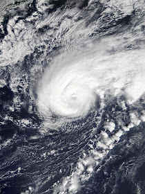
That day, a large eye finally broke through and hurricane hunters found that the system had become a major hurricane. It accelerated some to the east-northeast overnight and Bermuda began to experience wind and rain from the system's outer edge early on September 18. Conditions worsened quickly on the island and it was experiencing hurricane force winds by late that afternoon. Humberto was already taking on a more extratropical appearance, losing its eye and becoming asymmetric. Nevertheless, it maintained its strength as it made its closest approach to Bermuda late on the 18th. Sustained winds of 100 mph and higher gusts were measured on the island despite the center of Humberto passing a few dozen miles to the north. Just after moving away from the island, the storm reached peak intensity of 125 mph winds, measured with a pressure of 952 mb (up from a previous minimum of 951 mb). It turned northeast, accelerated further, and lost most of its central convection to strong wind shear on the 19th. This also resulted in gradual weakening and Humberto was extratropical by the afternoon of September 19. The remnant low sped northeastward toward the frigid north Atlantic before merging with another system.
The above image shows Hurricane Humberto as a large and dangerous major hurricane in the western Atlantic.
Humberto's large wind radii resulted in extensive impacts in Bermuda even as the center of circulation passed to the north.


No comments:
Post a Comment