Pages

Friday, December 15, 2023

2023 Season Summary

The 2023 Atlantic hurricane season was above average in activity, with a total of

21 cyclones attaining tropical depression status,
20 cyclones attaining tropical storm status,
7 cyclones attaining hurricane status, and
3 cyclones attaining major hurricane status.

Before the beginning of the season, I predicted that there would be

15 cyclones attaining tropical depression status,
14 cyclones attaining tropical storm status,
8 cyclones attaining hurricane status, and
4 cyclones attaining major hurricane status.

The average numbers of tropical storms, hurricanes and major hurricanes (over the 30 year period 1991-2020) were 14.4, 7.2, and 3.2, respectively. The eventual numbers for 2023 were well above my prediction for the total number of named storms, though my forecasts for hurricanes and major hurricanes were actually slight overestimates. The (preliminary) Accumulated Cyclone Energy value for the 2023 season is 146, solidly above average. This measure of activity accounts both for strength and duration of tropical cyclones. The exact value sometimes shifts when post-season analysis is complete. Overall, the 2023 season was a mixed bag, well above average in some indicators and near to slightly below in some others. This reflected the unusual conditions that made predicting 2023's outcome particularly tricky.


The 2023 season took place during a fairly strong El Niño event, meaning that equatorial Pacific sea surface temperatures were well above recent normals (the anomalies in different regions are shown in the diagram above). There's a well-established correlation between these anomalies and weather trends throughout the rest of the world, including stronger shear over the Atlantic ocean and a weaker Bermuda high. These tend to led to suppressed hurricane activity and more storms curving out to sea, respectively.


Though several cyclones this season struggled with wind shear, the overall wind shear pattern was not the typical one for an El Niño (see the figure above). Indeed, most of the main development region of the Atlantic basin had below-normal zonal wind shear, where zonal means the component of wind shear in the longitudinal direction. The following diagram illustrates just how unusual this combination of low wind shear and El Niño is, relative to the historical record.


The primary reason that El Niño did not behave normally was the incredibly warm sea surface temperatures in the tropical Atlantic. These warm waters were the result of a combination of anthropogenic global warming and a spring of very weak trade winds, which left the surface portion of the ocean unmixed with cooler waters below. This helps to explain the large number of named storms that formed in 2023. Fortunately for many land areas, however, the other common effect of El Niño did manifest: the Atlantic subtropical ridge was extremely weak all season, allowing many storms to recurve out to sea without affecting land. This included the season's strongest storm, category 5 Hurricane Lee. In fact, 2023 had the lowest death toll and damages from tropical cyclones dating back at least to the 2015 season.

2023's activity also came in intense bursts. The month of June was quite active with three named storms, including two tropical storm formations (Bret and Cindy) in the tropical Atlantic, which is the first such occurrence on record. After that, only one storm formed between June 26 and August 19! The floodgates opened after that, however, with the period from August 20 and September 28 seeing the formation of a whopping 13 named storms (a new record, beating 2020), and 5 hurricanes (tying a record last set in 2012). November, the last month of hurricane season, saw no formations at all.

In my region-by-region predictions, I forecasted that the Caribbean islands would be at high risk this season, and that the coast of the Gulf of Mexico and U.S. east coast would be at relatively low risk. These predictions were reasonably accurate, since the majority of tropical cyclones which affected land this year did so in the Lesser Antilles. Of course, Hurricane Idalia's category 3 landfall in the big bend region of Florida was the one major exception. Idalia caused significant impacts, but they were smaller in magnitude compared to other major hurricane impacts in the region in previous years due to the landfall location and the relatively small radius of maximum winds. Some other notable facts or records from 2023 include:
  • Though it wasn't operationally identified at the time, a unnamed subtropical cyclone formed in the northwestern Atlantic on January 16, and became the strongest tropical or subtropical Atlantic cyclone ever recorded in January
  • Hurricane Franklin's minimum pressure of 926 mb was the lowest ever recorded in a tropical cyclone that far north in the open Atlantic
  • Tropical Storm Philippe claimed the unusual record of longest-lasting Atlantic tropical cyclone with a peak intensity of under 70 mph


The 2023 season was unpredictable from start to finish, but ultimately had relatively mild impacts compared to many other recent years.

Sources: https://www.cpc.ncep.noaa.gov/products/analysis_monitoring/lanina/enso_evolution-status-fcsts-web.pdf, https://yaleclimateconnections.org/2023/11/the-unusual-2023-atlantic-hurricane-season-ends/, https://tropical.colostate.edu/Forecast/2023-11.pdf

Monday, October 23, 2023

Tropical Depression Twenty-One (2023)

Storm Active: October 23-24

Around October 20, a broad area of low pressure in the far southwestern Caribbean sea began to organize. It drifted very slowly westward and became more concentrated, all the while bringing heavy rains to the neighboring central American countries. During the afternoon of October 23, it was designated Tropical Depression Twenty-One. There was no time for the system to develop any more, however, because it made landfall that very night in central Nicaragua. The main impact was heavy rainfall. Twenty-One dissipated by the next morning.


The image above shows Twenty-One shortly after formation.


Twenty-One only became a tropical cyclone less than 12 hours before landfall in Nicaragua.

Thursday, October 19, 2023

Hurricane Tammy (2023)

Storm Active: October 18-26,27-29

Around October 10, yet another late season tropical wave entered the eastern tropical Atlantic. The system gained organization as it moved westward and appeared to be close to tropical depression status on October 14. However, no well-defined center formed, and conditions became a little less favorable over the next few days. Thunderstorm activity in association with the broad low became more diffuse, and it took even more time for it to regroup. It wasn't until October 18 that the system finally was upgraded to Tropical Storm Tammy. At that time, it was 1000 kilometers east of the Windward Islands.

Tammy developed a fairly impressive central dense overcast and had good inflow on satellite imagery, but the vortex also showed clear tilt and was elongated northwest to southeast. This limited significant strengthening in the short term, but aircraft reconnaissace did find that Tammy was producing sustained winds of around 60 mph on October 19, making it a fairly strong tropical storm. The next day, the cyclone reorganized somewhat and developed a very small core. This led to a short burst of intensification and Tammy was a category 1 hurricane late that morning. The storm gradually turned toward the northwest as it approached the Lesser Antilles. Its center passed just to the east of Martinique and Dominica on the morning of October 21. Though scattered heavy rainfall was widespread across the nearby islands, the small windfield of Tammy kept hurricane-force winds off of land for the most part.

After a bit more strengthening, Tammy reached its first peak intensity of 85 mph winds and a pressure of 988 mb later on the 21st. The center made a direct landfall in Barbuda that evening, bringing severe impacts to the small island. After that, the storm moved gradually away from the Caribbean islands, though rainfall lingered from the outer bands through October 22. The storm continued to round the periphery of the subtropical ridge and turned north. It maintained category 1 strength and continued to exhibit a small but powerful area of central convection.

In the subtropics, Tammy turned northeast and encountered a more diffluent upper-level environment. This began another period of strengthening late on October 24 and an eye appeared on satellite imagery the next morning. Tammy soon reached its peak intensity as a category 2 hurricane with 105 mph winds and a minimum pressure of 965 mb. Later in the day, stronger shear set in as the storm began to interact with a nearby front and weakening began. The storm underwent a rather quick extratropical transition early on October 26. Little more than a day later, though, ex-Tammy separated from the front and became a tropical cyclone again. At that point, it was estimated to be a strong tropical storm in intensity.

The storm remained very compact, with deep convection occurring only very close to the center. Therefore, even though it was rather close to Bermuda, the island did not receive any severe impacts. It moved south of east away from Bermuda after that and gradually weakened due to dry air around it. Warm ocean waters could not counteract the unfavorable atmospheric environment and Tammy lost deep convection by late on October 28. It became post-tropical for the final time early on the 29th.


The image above shows Hurricane Tammy at peak intensity as a category 2 on October 25.


Tammy's primary impacts were to the Leeward Islands.

Friday, October 13, 2023

Tropical Storm Sean (2023)

Storm Active: October 10-15

On October 6, a late-season tropical wave entered the Atlantic. By October, the Intertropical Convergence Zone retreats southward toward the equator, so tropical waves tend to form at lower latitudes. This system was no exception; it tracked westward over the next couple of days at around 7.5° N, passing well to the south of Cabo Verde. Though the wave was producing widespread thunderstorms, it took time to spin up. Late on October 10, it had acquired enough organization to be designated Tropical Depression Nineteen. The next morning, it was upgraded to Tropical Storm Sean.

A gap in the ridge to Sean's northwest allowed it to turn right and gain some latitude over the next few days. Due to wind shear, the storm remained disorganized. It even weakened to a tropical depression late on October 11 before regaining tropical storm status the next morning when a larger area of convection developed on the east side of the circulation.

Shear over the system relaxed somewhat after that, but Sean faced the new obstacle of very dry air aloft. This proved to be a more potent adversary for the cyclone; it weakened and grew increasingly shallow on the 14th, returning to tropical depression status. Intermittent convective bursts allowed the storm to retain its status as a tropical cyclone into the 15th, but they became steadily less organized. The decaying storm also turned back toward the west in the low-level flow. Late that day, the system became a remnant low. Not long after, the remnants dissipated east of the Leeward Islands.


The image above shows Sean as a disorganized tropical storm on October 13.


Sean did not affect any land areas.

Saturday, September 30, 2023

Tropical Storm Rina (2023)

Storm Active: September 28-October 1

On September 23, a fairly late season tropical wave entered the Atlantic. It moved westward at a low latitude, passing well south of Cabo Verde and crossing the tropical Atlantic at a steady pace. By the 26th, an area of low pressure had developed along the wave, but the last push to tropical storm status was slow-going due to the size of the disturbance and the fact that Tropical Storm Philippe was close by to the northwest. Around the same time, the system turned rather sharply toward the north-northwest as it began a binary interaction with Philippe. A closed circulation became evident on September 28 and the disturbance was named Tropical Storm Rina.

The storm was over warm water but faced strong westerly wind shear and some disruption from the interaction with Philippe, which was only a little over 500 miles away to the west. Therefore, convection was confined primarily to the south and east of Rina's center. Due to the Fujiwhara effect, Philippe and Rina began to orbit each other cyclonically, which meant that Rina picked up speed and turned toward the west-northwest over the next couple of days. On September 30, the storm turned poleward and separated from the binary interaction, weakening as it did so. The strong shear over Rina did not lessen, and the center lost definition on October 1. By late that evening, it had degenerated into a remnant low. What was left of Rina dissipated soon after.


The image above shows Tropical Storm Rina early on September 29. The eastern part of Tropical Storm Philippe is visible at left.


Rina was a short-lived tropical storm that did not affect land.

Saturday, September 23, 2023

Tropical Storm Philippe (2023)

Storm Active: September 23-October 6

Around September 19, another tropical wave entered the Atlantic. It moved west-northwest for the next few days and displayed some impressive thunderstorm activity, though it lacked a well-defined center. The system acquired enough organized to be classified Tropical Depression Seventeen on September 23, when it was roughly halfway between the African coastline and the Lesser Antilles. At the time of formation, the low-level center was rather west of the deepest convection, having outrun the rest of the system. Most of the mid-level spin was similarly displaced east of the center.

Despite battling wind shear, the system's satellite presentation improved steadily and it strengthened into Tropical Storm Philippe shortly after formation, with gradual intensification occurring thereafter. The center of the storm reformed northeast of its previous position on September 24, bringing the low-level circulation closer to the convective canopy. Over the next few days, wind shear increased some more, exposing the center again and slightly weakening Philippe. Sporadic bursts of thunderstorm activity continued to generate gale-force winds well east or southeast of the center, but the cyclone was very poorly organized as it continued generally westward. It turned northwest on September 27, but this motion was short-lived. In fact, Philippe was barely a tropical storm by the 28th: there appeared to be multiple centers of vorticity stretching east to west and the overall circulation was highly elongated.

Complicating the storm's situation further was newly formed Tropical Storm Rina to the east. The two storms influenced each other and began to orbit cyclonically around a common center due to the Fujiwhara effect. On Philippe's part, it slowed dramatically and took an unusual dip toward the southwest beginning late on the 28th and continuing through September 30. During that time, the center again became better defined and the storm deepened a little as a more solid central dense overcast became established.

The influence of Rina waned on October 1 as the distance between the cyclones increased. A mid-level ridge northeast of the storm became the dominant steering feature of Philippe's relatively shallow vortex, and it moved generally west-northwestward the next couple of days. The convection had become more vigorous, but was still displaced south and east of the center by shear for the most part. During the evening of October 2, the center of the storm made landfall in the island of Barbuda. Due to Philippe's structure, however, heavy rains spread into most of the Leeward Islands in the wake of the center's passing.

For the next day, the storm's center continued northwestward, passing north of the remaining Caribbean islands in its path, but the main area of convection moved almost due west into the northeastern Caribbean. This meant that heavy rainfall continued on the islands, but the cyclone itself lost organization as the separation between center and thunderstorm activity became greater and greater. By that night, the circulation was so ill-defined that Philippe was barely a tropical storm. New convection ultimately developed somewhat nearer the shallow vortex as the system turned north. Some of the activity was the result of the interaction of Philippe with a frontal boundary well north of the center, though. Regardless of its origin, this part of the storm swept over Bermuda by October 5 and brought tropical storm conditions there.

The next morning, Philippe's center was absorbed into the larger frontal system and it became post-tropical. The remnant low interacted with another non-tropical low to its west and the combined system ultimately deepened and swept into the upper northeast U.S. and Atlantic Canada by October 8.


The image above shows Philippe on September 27. The center is nearly exposed at the cloud cover's western edge. The storm struggled with wind shear nearly all of its existence.


Philippe was a meandering, long-lived, and hard-to-predict tropical storm. It has the strange distinction of being the first known Atlantic tropical cyclone to last as long as it did (13 days) without achieving maximum winds of more than 50 mph.

Tropical Storm Ophelia (2023)

Storm Active: September 22-23

Around September 18, a frontal boundary moved off the U.S. east coast over the Atlantic ocean. The southern end of the front stalled not too far from shore. A non-tropical low formed along that southern edge, just north of the Bahamas, on September 21. The low moved generally north or north-northwest and deepened rather quickly over the next day. During the afternoon of September 22, an area of deep convection developed on the western side of the storm, spiraling north and east away from the center. Though the system was asymmetric, satellite and aircraft reconaissance measurements indicated it had transitioned to a tropical storm. Therefore, it was named Tropical Storm Ophelia.

Ophelia was in an environment of rather strong shear and suffered from the aforementioned asymmetry. Despite this, it managed to strengthen some more as it approached land. The cyclone made landfall in North Carolina early on September 23 at its peak intensity of 70 mph winds and a pressure of 981 mb. The large system slowly pushed inland that day and gradually weakened, but brought a large area of storm surge, heavy rain, and tropical storm force winds to the mid-Atlantic. It weakened to a tropical depression that evening and became post-tropical shortly thereafter while located over southeastern Virginia. What was left of Ophelia turned north and then east, bringing more steady rain to the northeast as it weakened.


The above image shows Ophelia a few hours after becoming a tropical storm on September 22.


At the time Ophelia made landfall in North Carolina, the large storm's impacts were already being felt over an area that extended much further north.

Sunday, September 17, 2023

Hurricane Nigel (2023)

Storm Active: September 15-21

Around a week into September, another tropical wave entered the Atlantic. Several days later, it merged with another tropical disturbance to its east. This consolidation took some time, but gradual organization continued and ultimately culminated in the formation of Tropical Depression Fifteen on September 15. The circulation remained rather broad, but conditions were favorable for intensification. The depression strengthened into Tropical Storm Nigel late on the 16th. The storm moved steadily on a northwest path across the central Atlantic under the influence of a subtropical ridge.

Early on September 18, Nigel became a hurricane. The structure underwent an interesting evolution over the next day, with a very large eye opening up by the 19th. Initially, though, the convection around the eye was quite thin, especially on the north side. The eyewall became more solid throughout the day and Nigel intensified further to a category 2 hurricane. That night, the cyclone reached its peak intensity of 100 mph maximum sustained winds and a minimum pressure of 971 mb. Around the same time, it turned north, rounding the edge of the subtropical ridge.

On September 20, Nigel began to accelerate northeast as it was swept up by the mid-latitude westerlies. This soon brought the hurricane to cooler waters and a higher shear environment, causing it to gradually weaken. The remaining deep convection was displaced from the center the following day and the system transitioned to post-tropical in the evening.


The image above shows Nigel near peak intensity on September 19. Its eye was unusually large relative to the storm's total size, a feature more common in hurricanes in the subtropics.


Nigel did not directly affect any land areas as a tropical cyclone.

Thursday, September 7, 2023

Hurricane Margot (2023)

Storm Active: September 7-17

On September 5, another tropical wave entered the eastern Atlantic. It moved west-northwest and developed fairly quickly as it passed over Cabo Verde. In fact, it was still bringing rain to the westernmost islands of Cabo Verde when it was classified Tropical Depression Fourteen during the morning of September 7. Not long after that, it was upgraded to Tropical Storm Margot.

Margot faced a mixed-bag of conditions. It was moving over fairly warm ocean waters and faced only moderate wind shear. However, it was surrounded by a fairly dry environment, so it took time for the storm to develop deep convection. On September 8, the center became exposed to the southwest of the strongest thunderstorms. Nevertheless, Margot eventually managed to organize and began gradually strengthening on September 9. A more substantial inner core appeared the next day as the storm turned toward the north, following a weakness in the subtropical ridge.

By September 11, Margot was a well-organized storm with a partial eye and impressive outflow to the north. This brought it to hurricane strength. Margot had its ups and downs over the next couple of days as it chugged northward, with some dry air in the circulation but an inner core and eye occasionally visible on satellite imagery. The net effect of all this was a little more gradual intensification. Margot reached a peak intensity as a high-end category 1 hurricane with 90 mph winds and a central pressure of 970 mb on September 13.

After that point, the storm's core became a little more diffuse, but its windfield expanded as it gained latitude. On September 14, Margot turned right in the face of a ridge blocking its path, and started a slow clockwise loop west of the Azores. During the loop, the storm underwent a gradual decay as dry air eroded its thunderstorm activity. It weakened to a tropical storm on the 15th and lost nearly all convection by early on September 17. At that time, it became post-tropical.


The above image shows Margot at a hurricane on September 12.


Margot's only land impacts as a tropical cyclone were to Cabo Verde right after its formation as a tropical depression on September 7.

Wednesday, September 6, 2023

Hurricane Lee (2023)

Storm Active: September 5-16

On September 1, a strong tropical wave moved over the Atlantic from the west coast of Africa, producing a large area of vigorous thunderstorms near the coast as it did so. The system steadily gained organization as it moved westward at a fairly fast pace. A low pressure center formed on September 4 and the circulation became well-defined enough to designate the system Tropical Depression Thirteen on September 5. Very high sea surface temperatures in the tropical Atlantic allowed the storm to intensify quickly from that point as it moved west-northwestward. It became Tropical Storm Lee six hours after formation and developed prominant spiral banding almost immediately. Some slight northeasterly shear was not enough to prevent it from becoming a category 1 hurricane by the evening of September 6.

Conditions became even more favorable on September 7 and Lee's structure improved rapidly. The nascent eyewall, which was open to the west in the morning, closed off quite quickly after that and the stage was set for the hurricane to deepen at an incredible pace. The eye cleared out and became symmetric by the evening and Lee strengthened to a category 4 hurricane. That evening, Lee reached its peak intensity as a powerful category 5 hurricane, with maximum winds of 165 mph and a central pressure of 926 mb. These winds were the highest recorded in any Atlantic hurricane since Dorian of 2019. Shortly after that, wind shear disrupted the center of Lee and it began a weakening trend on September 8. The eye clouded over and the central dense overcast eroded, particularly on the west side. This brought the storm back down to a category 3 as it made its closest approach to the northeasternmost Caribbean islands.

Lee maintained its steady west-northwest heading, though its forward speed gradually slowed. The weakening halted on September 10, by which time the storm was a category 2. Its structure subsequently improved, though not to the level of its original burst of intensification. Lee regained major hurricane status that day. Further increases in winds were precluded by the storm's inner core organization, which consisted of a very large outer eyewall and a decaying partial inner eyewall. However, even though the winds did not increase further, the hurricane-force wind field had expanded significantly and continued to grow over the next few days.

By September 11, the storm had turned northwest and slowed further. Its path brought it well northeast of the Bahamas, though the large circulation caused large swells and rip currents to the Caribbean islands and U.S. east coast. Lee also traveled over the cool wake in ocean temperatures left behind by Franklin and exacerbated that issue by upwelling cool waters with its slow forward motion. As a result, a slow weakening began on September 13. The storm turned toward the north that day under the influence of an approaching trough. On September 14, Lee dropped to category 1 intensity and made its closest approach to Bermuda, passing well to the west. Regardless, the storm's large windfield brought a sustained period of tropical storm conditions to the island.

On the 15th, the cyclone became significantly less tropical in appearance, with dry air invading the southern semicircle and displacing convection northward. That evening, tropical storm conditions began across a wide area of coastal New England and Atlantic Canada. Early on September 16, Lee completed extratropical transition. Nevertheless, post-tropical Lee still brought winds to near hurricane force to Nova Scotia when it made landfall in the easternmost part of the province later that day. The center of the storm crossed the Bay of Fundy and made another landfall in New Brunswick very early on September 17. Weakening more quickly, ex-Lee moved over the Gulf of St. Lawrence and finally over Newfoundland on the way out to sea.


The image above shows Lee as a category 5 hurricane. Just after this satellite imagery, mid-level shear from the southwest disrupted the center and weakened the storm. The beginnings of this disruption are already apparent in the image.


Lee did not made landfall as a tropical cyclone but did have direct impacts on Atlantic Canada after becoming post-tropical.

Friday, September 1, 2023

Tropical Storm Katia (2023)

Storm Active: September 1-4

On August 28, a vigorous tropical wave entered the Atlantic. It moved west-northwestward over Cabo Verde, bringing strong storms to the islands on August 30. Two days later, it acquired enough organization to be designated Tropical Depression Twelve. The system began to move north-northwestward toward a low in the eastern Atlantic and strengthened into Tropical Storm Katia. Katia managed to develop a decent area of strong thunderstorms and intensified further, reaching peak winds of 60 mph on September 2.

However, as it gained latitude and moved away from the tropics, wind shear increased out of the south and the storm encountered much drier air. Rapid weakening followed. Katia slowed down and turned back northwest as it ran into a low-level subtropical ridge. It weakened to a tropical depression early on September 4 and then a remnant low later the same day.


The image above shows Katia at its peak intensity on September 2.


Katia did not threaten any land areas as a tropical cyclone during its journey through the eastern Atlantic.

Thursday, August 31, 2023

2023 Unnamed Subtropical Storm

Storm Active: January 16-17

NOTE: This post concerns a subtropical storm of the 2023 Atlantic hurricane season which formed in January of that year, but was not identified at the time. Reanalysis confirmed that it was in fact a subtropical cyclone a few months later. Since it was not named, the naming of storms later in the season began with "A" (see Tropical Storm Arlene), but the numbering of subsequent tropical depressions began with "Two".

On January 14, a trough became separated from a larger frontal boundary just off the U.S. east coast. A well-defined but non-tropical low formed off the mid-Atlantic states the next day. Water temperatures over the Gulf stream, while cold, were much warmer than normal for the region, allowing deep convection to develop. This lead to the formation of a subtropical storm around the morning of January 16. The cyclone underwent significant deepening that next day and turned northeast, then north. It reached a peak intensity of 70 mph sustained winds and a central pressure of 976 mb late on the 16th. During the morning of January 17, the cyclone made landfall in far eastern Nova Scotia, with estimated sustained winds of 50 mph at landfall. The storm continued northward, became post-tropical later that day, and dissipated on the 18th.


The image above shows the unnamed subtropical storm on January 16, with a distinct, eye-like feature.


The 2023 unnamed subtropical storm had the lowest central pressure of any January tropical or subtropical cyclone ever observed in the Atlantic.

Tuesday, August 29, 2023

Tropical Storm Jose (2023)

Storm Active: August 29-September 1

On August 19, a tropical wave moved off the African coast over the tropical Atlantic ocean. It moved across the Cabo Verde islands on August 21, bringing scattered downpours. The system moved slowly west-northwestward for several days. Conditions were marginally favorable, but the disturbance could not quite take advantage enough to be designated a tropical cyclone. It nonetheless plodded along, turning toward the north and entering the subtropical Atlantic. At that time, development was no longer expected, but the system make an unlikely comeback and finally became Tropical Depression Eleven on August 29, by which time it was located around 850 miles east-southeast of Bermuda.

The depression meandered for the next day and changed little in organization. Late on August 30, though, it began to pick up speed toward the north, feeling the influence of the large Hurricane Franklin approaching from the west. Somewhat surprisingly, the system's thunderstorm activity became significantly better organized early on the 31st, and it was upgraded to Tropical Storm Jose. The storm even managed to strengthen some more that night, reaching a peak winds of 60 mph.

On September 1, the small storm began to rocket northward, rapidly spiraling in toward the much larger circulation of Franklin, which became extratropical that afternoon. Despite increasing shear from the larger system, Jose maintained its identity through that evening and produced a trail of thunderstorm activity in its wake. Shortly after that, however, the system was at last absorbed into ex-Franklin.


The above image shows small Tropical Storm Jose over the open Atlantic.


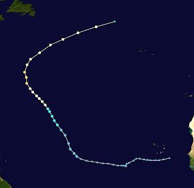
The disturbance that was to become Jose moved across the Atlantic for over a week before developing (triangle points).

Saturday, August 26, 2023

Hurricane Idalia (2023)

Storm Active: August 26-31

On August 24, an area of low pressure formed in the far western Caribbean, extending over the neighboring Yucatan peninsula. It gradually made its way north and became better organized. On August 26, a closed circulation developed in the Yucatan channel between the northeast peninsula and western Cuba. The system was designated Tropical Depression Ten that afternoon. Steering currents near the depression were initially very weak. As a result, the newly formed center meandered in a counterclockwise loop over the next day, executing a turn toward the south, east, and then finally north by the next day. In the meantime, some dry air was entrained into the circulation from the north and west, but this was not enough to stop the gradual improvement of the cyclone, to the point that it was named Tropical Storm Idalia on the 27th.

Idalia was a large cyclone, and took some time to spin up. A large burst of convection covered the center that evening and slow strengthening ensued, though the center remained close to the northern edge of the convective mass. Meanwhile, a trough over the U.S. finally got the storm moving, generally toward the north. Idalia passed very close to the western tip of Cuba during the evening of August 28, bringing tropical storm conditions to that area. Overnight, a more substantial inner core structure developed and the storm reached hurricane strength early on August 29. By that time, it was accelerating a bit on its northward heading into the eastern Gulf of Mexico.

Gulf waters were extremely warm, near record high temperatures in many locations. It took Idalia some time to build an eyewall, but by late that day it was intesifying rapidly. Though the storm overall was large, the central dense overcast and hurricane-force wind radius were rather small. Likewise, the eye that cleared out on satellite imagery late on the 29th was small. Nevertheless, the storm had become an extremely formidable hurricane by early on August 30, reaching its peak intensity as a low-end category 4 with 130 mph winds and a central pressure of 940 mb. An eyewall replacement began just before landfall, weakening the cyclone slightly, and Idalia made landfall in the "big bend" of Florida around 7:45am local time with maximum winds of 125 mph and a central pressure of 947 mb.

The storm weakened quickly over land and moved northeast, crossing into Georgia while still a hurricane. By the 30th, the center was crossing South Carolina; it moved over the Atlantic later that day. The core had completely eroded by that point and Idalia was down to a tropical storm. It was also transitioning to extratropical thanks to an interaction with the trough to its northeast. The storm was completely devoid of central convection by August 31 and finished extratropical transition that afternoon.

The large circulation of Idalia moved generally eastward toward Bermuda. Its motion gradually slowed on September 1 and windy conditions began on Bermuda, though there was almost no rain associated with ex-Idalia. Some deep convection began to redevelop northeast of the center that evening. However, the storm remained entangled with a front and did not regain tropical characteristics. The storm began to move northeast away from Bermuda on September 3.


The above infrared image shows Idalia at peak intensity as a category 4 hurricane in the early hours of August 30.


Idalia caused significant storm surge in northwest Florida; the shape of the coastline and large continental shelf in that region compounds the risk of storm surge.

Monday, August 21, 2023

Tropical Storm Harold (2023)

Storm Active: August 21-23

During the third week of August, a tropical disturbance moved through the western Atlantic, across southern Florida, and finally into the Gulf of Mexico on August 20. The system was generating a large area of thunderstorms on its northern side, but the circulation was rather broad as it tracked quickly westward. Nevertheless, it acquired enough organization to be classified Tropical Depression Nine on August 21. Overnight, the cyclone strengthened into Tropical Storm Harold. However, its rapid pace of motion did not leave Harold much time to strengthen; it made landfall in south Texas during the morning of August 22.

The storm's broad circulation and ample moisture did slow its weakening as it moved inland, though, allowing the storm to bring a swath of heavy precipitation all the way across Texas and northern Mexico over the following day. It weakened to a tropical depression late on the 22nd and to a remnant low on the 23rd.


The image above shows Harold making landfall in south Texas on August 22.


A strong ridge of high pressure to Harold's north steered the cyclone quickly across the Gulf of Mexico and over land.

Hurricane Franklin (2023)

Storm Active: August 20-September 1

Around August 17, a disturbance began to consolidate in the tropical Atlantic several hundred miles east of the Lesser Antilles. It originated as part of a sprawling trough of low pressure which extended far to the east-northeast and spawned two other tropical cyclones, Emily and Gert. The system crossed into the Caribbean sea on August 19, bringing heavy rain to the Windward Islands as it passed over. The system was facing some wind shear but conditions were otherwise favorable. This led to the formation Tropical Storm Franklin on August 20.

Franklin struggled to maintain a well-defined center of circulation over the next few days, not an unusual battle for cyclones in the eastern Caribbean. It had plenty of warm water and atmospheric moisture to work with, but wind shear inhibited it from gaining much strength, and in fact the low-level center reformed in different locatinos a couple of times. The storm at first had moved west, but it turned sharply toward the north by the 22nd under the influence of a trough over the western Atlantic. This ultimately brought the center over the Dominican Republic during the morning of August 23. The main impacts to Hispaniola were heavy rain. Franklin emerged over the open Atlantic late that afternoon.

The atmospheric steering currents collapsed the next day and the system slowed down and began an unusual turn to the east. Persistent wind shear out of the northwest also kept deep convection primarily to the southeast of the center. This prevented Franklin from strengthening much through August 25. That morning, the storm turned southeastward under the influence of an upper-level anticyclone in the Caribbean. It is very rare for a storm to move on a southeast heading in the tropics, especially before the very end of hurricane season.

Franklin's environment soon changed rather significantly, though. An upper-level low cut off to its west and it turned rather sharply back toward the northwest over the next day under the influence of this low. At the same time, wind shear lessened considerably, allowing the cyclone to become more symmetric and strengthen. Moderately dry air near the storm kept the thunderstorm activity limited, but this wasn't enough to prevent significant deepening on August 26 as hints of an eye appeared on satellite imagery. Franklin intensified into a category 1 hurricane that morning.

Spiral banding in the storm improved throughout the day as it continued slowly northwestward. It reached category 2 on August 27 and turned toward the north. However, it was the next day that Franklin really broke through, clearing out a large and circular eye. In a significant burst of strengthening, it became the first major hurricane of the season early in the morning of the 28th and then a category 4 shortly after. Franklin reached its peak intensity that evening with 150 mph winds and a central pressure of 926 mb. This pressure reading was the lowest yet recorded in an Atlantic hurricane over the open Atlantic (not the Gulf of Mexico) so far north, at 29 ° N. It was the lowest pressure in any Atlantic hurricane overall in nearly 3 years, since Iota of 2020.

On August 29, the satellite presentation degraded somewhat as the storm experienced an eyewall replacement cycle. Franklin weakened to a category 3. For a time, the storm cleared out a large new eye, but wind shear began to increase out of the north the next day, due to a combination of a large trough moving off the U.S. northeast and trailing Idalia in its wake. The storm was still a category 2 when it passed north of Bermuda; its wind field was large enough to bring tropical storm force winds to the island.

Franklin weakened to a category 1 on the 31st and also began extratropical transition as it sped toward the northeast. This transition completed on September 1, at which time the storm became a hurricane-force extratropical low. This low absorbed the much smaller Tropical Storm Jose late that night. The system ultimately moved eastward across the northern Atlantic and combined with another low pressure system off the coast of Europe.


The image above shows Franklin shortly before reaching peak intensity on August 28.


Franklin's unusual track was difficult to forecast due to a complicated combination of steering influences.

Sunday, August 20, 2023

Tropical Storm Gert (2023)

Storm Active: August 19-22, September 1-4

Around August 14, a tropical wave around halfway between west Africa and the Caribbean showed some modest signs of organization. It moved roughly west-northwestward over the next few days. By the 16th, a large area of vorticity was had developed across the eastern tropical Atlantic, with the aforementioned disturbance at its western end. Weak low pressure centers formed at both ends; the eastern one eventually became Tropical Storm Emily. Around August 17, another low actually formed even farther west of our system, still associated with the overall monsoon trough. That low moved into the Caribbean and eventually became Franklin. All of this interaction made it harder for the system to consolidate; in addition, the farther north the disturbance tracked, the closer it came to a large area of Saharan dry air. Nevertheless, the western low ultimately became better defined and deep convection persisted near the center long enough that it was classified Tropical Depression Six on August 19.

By the time it formed, Six was around 850 miles east of the northeasternmost Caribbean islands. However, there was an upper-level trough located near the greater Caribbean islands, which sheared the storm more strongly as it continued westward. It struggled to maintain thunderstorm activity over the center on August 20. Despite all of its struggles, the cyclone produced vigorous enough convection to generate gale force winds that night and was upgraded to Tropical Storm Gert early on August 21. The storm began to weaken again soon after and became a tropical depression later that day. Gert persisted longer than expected, but ultimately weakened into a remnant low on August 22, not too far from the Leeward Islands.

Gert's remnants turned north-northwest and very slowly moved toward the subtropical Atlantic. After about a week of this, a low-pressure redeveloped in association with the system, and it began to get better organized again. On September 1, a remarkable ten days after ceasing to be a tropical cyclone, the disturbance was once again Tropical Depression Gert. Nor did it stop there. That afternoon, its cloud pattern became more organized and it strengthened into Tropical Storm Gert. At first, the storm didn't move very much, but it soon felt the influence of an extratropical low to its west, which was the remnant of Hurricane Idalia. This steered Gert toward the north-northeast with increasing speed. Despite some northerly wind shear, it strengthened on September 2, reaching a peak intensity of 60 mph winds and a central pressure of 998 mb.

At last, the hostile atmospheric environment began to take a toll on Gert. It weakened a little and most thunderstorm activity was stripped away from the center on September 3. The small cyclone turned north and then west of north as it spiralled toward the powerful ex-Idalia located southeast of Atlantic Canada. It dissipated and merged with this larger storm late in the morning on September 4.


The image above shows the small but persistent Tropical Storm Gert on September 3. The edge of the cloud pattern of the extratropical low which was once Hurricane Idalia is visible at left.


Gert had an unusual history, with two periods of time as a tropical cyclone separated by 10 days as a disturbance wandering the western Atlantic.

Tropical Storm Emily (2023)

Storm Active: August 20-21

On August 15, a tropical wave emerged into the tropical Atlantic ocean. It moved west-northwestward over the next few days and produced disorganized shower activity as part of a large area of unsettled weather which included both it and another disturbance several hundred miles to its west-southwest. Both systems developed low pressure centers, but their progress toward becoming tropical cyclones was hindered by their proximity. The western system ultimately became Tropical Storm Gert. By that time, the eastern low was producing gale-force winds, but the circulation was not well-defined enough to yet be named. That changed on August 20, when it finally became Tropical Storm Emily.

By the time Emily was named, its window of opportunity to strengthened had already closed. Wind shear and drier air overwhelmed the system, stripping it of any deep convection by early morning on August 21. Later that morning, it became a post-tropical cyclone, only one day after forming. What was left of the storm tracked northwest for several more days. Along the way, it encountered somewhat more favorable atmospheric conditions, but it could not take advantage of them to the point of redeveloping.


Emily was a sheared tropical storm during its brief existence.


Most of the track shown here shows when Emily was not a tropical cyclone (triangle points). It was only a tropical storm for a day (circle points).

Saturday, July 15, 2023

Hurricane Don (2023)

Storm Active: July 14-24

On July 11, an area of low pressure formed east-northeast of Bermuda. The system moved slowly eastward over the next few days and deepened a bit, though the Atlantic waters at that latitude were only lukewarm and atmospheric conditions weren't ideal for development. At first, thunderstorm activity was disorganized and displaced southeast of the vorticity center, but a curved banding structure emerged by July 13, wrapping more tightly around the low-pressure center. The storm began to produce gale force winds as well. At that point, the low was still elongated and extratropical in apperance. On July 14, however, it became better defined and the system was classified Subtropical Storm Don. The subtropical classification was due to the broad and diffuse convective structure and its interaction with an upper-level trough nearby.

Don was named with 50 mph winds and actually weakened slightly during the following day. The center was meandering a great deal, but the storm generally moved northward through July 15. There was a ridge of high pressure steering Don from the west, and the storm began a slow clockwise loop around it as the ridge pressed eastward over the following days. Ocean temperatures under the system became yet colder and could not be totally offset by colder-than-usual upper-atmospheric temperatures. As a result, Don weakened to a subtropical depression on July 16. On July 17, the storm was reclassified as a tropical depression after separating from the upper-level trough.

Don strengthened into a tropical storm overnight but still looked unimpressive on satellite imagery. Around midday on the 18th, Don was halfway through its large loop and was moving south, which returned it to a more conducive environment with warmer seas and lower shear. Soon after that, the storm finally developed some consistent deep convection over the center. This allowed it to begin some modest intensification. It turned west, then northwest over the next couple of days. Around July 20, Don developed an eyelike feature at the center of its very small central dense overcast. The storm was so small that it struggled to mix the dry air out of the very compact circulation. However, it got a boost on July 22 from passing over the slightly warmer waters of the Gulf Stream and vaulted to hurricane strength, becoming the first hurricane of the 2023 Atlantic hurricane season.

Hurricane Don peaked with winds of 75 mph and a minimum pressure of 988 mb late on the 22nd. Overnight, the storm moved north of the Gulf Stream and sea surface temperatures underneath it began to plunge. The system was recurved toward the northeast and soon weakened to a tropical storm. It lost the last of its deep convection by early on July 24 and became post-tropical shortly after that. The remnants dissipated another day or so later.


The above image shows Don as a hurricane on July 22. The cyclone had an impressive but small core, and became a hurricane at a fairly high latitude.


Don was a long-lived storm by July standards; it lingered around the subtropical Atlantic over 10 days and became at the time the fifth longest-lasting July storm (including time both as a tropical and a subtropical cyclone). Subtropical points are squares in the above track, while tropical points are circles. Triangles denote points where the system was not yet named or post-tropical, and are not counted toward its longevity. Despite its long life, Don never affected any land areas.

Thursday, June 22, 2023

Tropical Storm Cindy (2023)

Storm Active: June 22-25

Around June 17, a new tropical wave showed signs of development in the eastern Atlantic. Though thunderstorm activity was limited at first, it blossomed on June 20 when persistent convection covered the nascent circulation. Finally, early on June 22, the small system was organized enough to be designated Tropical Depression Four.

Initially, the center of circulation was on the eastern edge of the convective canopy, but the storm gradually became better organized throughout the day and was ultimately named Tropical Storm Cindy that evening. The previously formed Tropical Storm Bret and Cindy both formed in the tropical Atlantic east of the Caribbean sea during the month of June, the first time on record two storms had been named in that region during hurricane season's first month. It was also the first instance of simultaneous June named storms since 1968. The extremely warm waters in the vicinity were the main cause of that event.

Cindy was moving west-northwest steadily under the influence of the subtropical ridge, which had retreated northward a bit after keeping Bret on a more westward trek into the Caribbean. The storm intensified on June 23, though in fits and starts: it developed a banding structure in the early morning only for most convection to collapse in the afternoon and then return with a venegeance in the evening. The net result was that Cindy reached a peak of 60 mph winds before increasing shear began to expose the center of circulation again, this time on the northwest side of the thunderstorm activity.

Cindy turned toward the northwest and passed well northeast of the Lesser Antilles on June 24. The wind shear affecting the cyclone shifted to come from the southwest and increased even more. The storm's structure did not long survive this onslaught and Cindy dissipated late on June 25.


The image above shows Cindy northeast of the Lesser Antilles.


Cindy reached an area of high shear after passing 60 °W and dissipated not long after that.

Monday, June 19, 2023

Tropical Storm Bret (2023)

Storm Active: June 19-24

On June 15, a vigorous tropical wave moved over the eastern tropical Atlantic from mainland Africa. It was the first tropical wave of the 2023 season to show signs of development upon entering the basin, and marked a rather early start to the Cabo Verde hurricane season. The system moved quickly westward and steadily organized. By the 18th, there was rotation evident in the satellite signature; the next day, Tropical Depression Three formed.

Shortly afterward, the depression strenghtened into Tropical Storm Bret. Ocean temperatures and atmospheric humidity both favored further intensification, but its fast motion and some mid-level westerly shear made it more difficult for it to build a central core. Nonetheless, the storm's maximum winds increased steadily on June 20. Bret reached its peak intensity of 70 mph winds and a central pressure of 996 mb very early on June 22. It was near hurricane strength, but was rather lopsided and didn't have much spiral banding on satellite.

Later that morning, increasing wind shear caught up with the cyclone as the center of circulation began to outrun the convection to the west. The storm began to weaken but passed among the Leeward Islands that night still as a strong tropical storm, bringing strong winds to the islands. Bret picked up more speed toward the west as it traversed the eastern Caribbean on June 23. Even after the center had moved a few hundred miles to the west, the storm generated heavy rains over the Leeward Islands from all the moisture that the wind shear had displaced eastward.

Bret's center steadily degraded over the following day and it weakened. The storm took a fast southern route through the Caribbean and passed barely north of the Venezuelan coastline during the morning of June 24. Later that day, the circulation opened up and Bret dissipated north of Colombia. Some of the storm's remnants ultimately contributed to the formation of Hurricane Beatriz in the Eastern Pacific a few days later.


The image above shows Bret near peak intensity in the open tropical Atlantic. Though Bret neared hurricane strength, it never acquired the typical central dense overcast typical of a storm of that caliber.


As with many tropical storms with similar track before it, Bret ultimately succumbed to the hurricane graveyard of the eastern Caribbean.

Friday, June 2, 2023

Tropical Storm Arlene (2023)

Storm Active: June 1-3

Near the end of May, an area of thunderstorms formed in association with a trough over the Gulf of Mexico. A circulation gradually developed as it drifted northward. On the first official day of the Atlantic hurricane season, June 1, the low was classified Tropical Depression Two. It was given the "Two" designation because of the unnamed subtropical storm that had formed in January 2023. When it first formed, the depression was colocated with an upper-level trough; this gave it a pocket of mildly favorable conditions for intensification. It took advantage and strengthened into Tropical Storm Arlene on June 2, becoming the first named storm of the season.

Atmospheric conditions quickly soured after that, however. The aforementioned trough pushed eastward, exposing the cyclone to wind shear and encroaching dry air from the west. Though the storm formed with the Gulf coast nearby to the north and east, it actually picked up steam toward the south and moved away from land, following the flow of the trough. By later that day, it began to weaken. Early on June 3, it turned east of south and diminished into a tropical depression; it became a remnant low just hours later in the southern Gulf of Mexico adjacent to Cuba.


Arlene peaked as a weak tropical storm before being quickly snuffed out by dry air and unfavorable wind shear.


Arlene's southward track was somewhat unusual; it did not affect land during its brief lifetime.

Saturday, May 27, 2023

Professor Quibb's Picks – 2023

My personal prediction for the 2023 North Atlantic Hurricane season (written May 27, 2023) is as follows:

15 cyclones attaining tropical depression status,
14 cyclones attaining tropical storm status,
8 cyclones attaining hurricane status,
4 cyclones attaining major hurricane status.

This prediction is near the 1991-2020 averages of 14.4 tropical storms, 7.2 hurricanes, and 3.2 major hurricanes each season in the Atlantic basin. I expect that 2023 will thus be an about average season. Below, I'll discuss the various factors involved in making this prediction. Note that the the NOAA identified a unnamed subtropical storm that formed in January 2023 in the western subtropical Atlantic, which was not designated operationally at the time. This storm is included in the above total, and will be covered on this blog once a tropical cyclone report on it is released.

I'll begin as usual with the El Niño Southern Oscillation (ENSO) index. Though simply a measure of sea surface temperature anomalies in the equitorial Pacific Ocean, it is correlated with trends in tropical cyclone activity all around the globe. For the Atlantic specifically, warmer than normal Pacific waters (El Niño) tend to give quieter Atlantic seasons, while cooler than normal waters (La Niña) lead to busier Atlantic seasons. It's worth noting that our understanding of this phenomenon, as well as possibly the ENSO cycle itself, has changed over the last few decades.
Indeed, even as oceans have drastically warmed overall over the past 40 years due to anthropogenic climate change, the equatorial Pacific has actually slightly cooled; relative to average, La Niña events have been much more frequent and intense recently than El Niño ones (read more here). For instance, La Niña conditions dominated for almost three years from 2020-2023. It's not certain exactly how or why this is occurring. Nevertheless, in 2023 specifically, things are changing.
A rapid warming is underway in the Pacific, and it's widely expected that an El Niño will begin soon, becoming moderate to strong by the latter half of hurricane season. This should have a significant suppressing effect on Atlantic tropical cyclone activity come summer.

Nevertheless, there are some signs that point in the opposite direction.


Moving from the Pacific to the Atlantic, we also see above average sea surface temperatures in the main cyclone formation regions, including the tropical Atlantic, the Caribbean, and the Gulf of Mexico. The effect of these anomalies on hurricane formation is more straightforward: warmer oceans mean more favorable conditions for development and intensification. It's worth noting that some of the warmest areas are in the tropics rather than the subtropics this year, where they will likely give a greater boost to tropical cyclones. The best recent historical analog for this sea surface temperature profile in May is 2010, a very active hurricane season.

One last major factor to examine is wind shear. The figure below, from Colorado State University's annual hurricane forecast report, shows different possible atmospheric wind profiles and how they might influence Atlantic hurricane activity.


The graphic above shows two possible scenarios for wind shear across the MDR (Main Development Region) of the Atlantic. The vertical direction indicates height in the atmosphere, and the horizontal axis is the component of the wind speed in the west-east direction (left is west, right is east) averaged across the indicated area. At lower altitudes, the east-to-west trade winds dominate the scene, but the wind direction may often change several miles aloft. The change of west-east wind speed with height is known as zonal wind shear and has significant implications for cyclone activity. In the unfavorable (blue) profile, the surface trade winds are stronger but the winds switch east near the top of the troposphere, the layer of Earth's atmosphere where most weather occurs. This makes it difficult for vertically aligned vortices to form, because different levels of a nascent circulation are pushed in opposite directions.

The red profile, in contrast, is a relatively uniform westerly wind at every level, meaning wind shear is low and conditions are favorable for tropical cyclone development. CSU takes spring zonal wind shear measurements into account when making their forecast; this shear has been a bit lower than normal for 2023 so far. Of course, this could change: El Niño also sometimes brings about a high zonal shear regime across the Atlantic. Putting all this together, I'm forecasting a near average hurricane season. I'll give a finer analysis of the risks by region. My estimates are on a scale from 1 (least risk) to 5 (most risk).

U.S. East Coast: 2
I'll put the east coast at lower than usual risk this year. The subtropical Atlantic has consistently been dominated by troughs this year so far, so cyclones reaching the latitude of the east coast have a good chance of recurving to the east. The oncoming El Niño may bring an early fall to the continental U.S., shutting down development in this region by October.

Yucatan Peninsula and Central America: 3
A more active Pacific hurricane season could help suppress cyclone formation on the other side of central America this summer. However, Atlantic waters are particularly warm in the southwestern Caribbean, which is always a danger zone for rapid intensification. I expect most of the season to be quiet in this region, but the possibility of a few strong storms brings the risk up to a 3.

Carribean Islands: 4
El Niño aside, the tropical Atlantic looks as favorable as it has looked in a while: temperatures are very warm, and the Saharan air layer is less prominent than usual near Africa. Look for possible long-track hurricanes forming and affecting the Caribbean islands, before likely turning northward. I'll put the eastern islands at greater risk than the western ones.

Gulf of Mexico: 2
The same factors at play for the U.S. East Coast give a similar story here. Though waters are warm, I think shear and atmospheric steering currents should shield the Gulf coast from the worst impacts, particularly during the latter half of the season. July and August may be the riskiest months for a Gulf hurricane landfall if one does occur.

Overall, I expect the 2023 Atlantic hurricane season to be around average, with perhaps a slightly larger number of hurricanes and major hurricanes than usual (though I expect most of these to go out to sea). Nevertheless, this is just an amateur forecast. Individuals in hurricane-prone areas should always have emergency measures in place. For more on hurricane safety sources, see here. Remember, devastating storms can occur even in otherwise quiet seasons.

Sources: https://yaleclimateconnections.org/2023/04/a-mystery-in-the-pacific-is-complicating-climate-projections/, https://www.nhc.noaa.gov/sst/rsst_atl_anom_loop.php, https://tropical.colostate.edu/forecasting.html