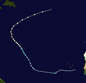
Storm Active: September 15-21
Around a week into September, another tropical wave entered the Atlantic. Several days later, it merged with another tropical disturbance to its east. This consolidation took some time, but gradual organization continued and ultimately culminated in the formation of Tropical Depression Fifteen on September 15. The circulation remained rather broad, but conditions were favorable for intensification. The depression strengthened into Tropical Storm Nigel late on the 16th. The storm moved steadily on a northwest path across the central Atlantic under the influence of a subtropical ridge.
Early on September 18, Nigel became a hurricane. The structure underwent an interesting evolution over the next day, with a very large eye opening up by the 19th. Initially, though, the convection around the eye was quite thin, especially on the north side. The eyewall became more solid throughout the day and Nigel intensified further to a category 2 hurricane. That night, the cyclone reached its peak intensity of 100 mph maximum sustained winds and a minimum pressure of 971 mb. Around the same time, it turned north, rounding the edge of the subtropical ridge.
On September 20, Nigel began to accelerate northeast as it was swept up by the mid-latitude westerlies. This soon brought the hurricane to cooler waters and a higher shear environment, causing it to gradually weaken. The remaining deep convection was displaced from the center the following day and the system transitioned to post-tropical in the evening.
The image above shows Nigel near peak intensity on September 19. Its eye was unusually large relative to the storm's total size, a feature more common in hurricanes in the subtropics.
Nigel did not directly affect any land areas as a tropical cyclone.


No comments:
Post a Comment