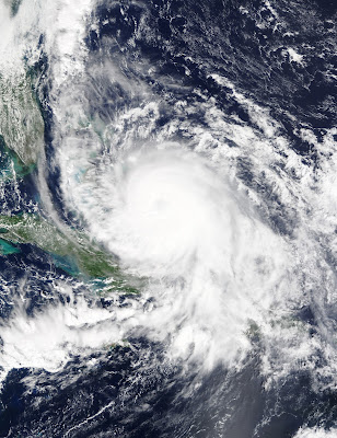
Storm Active: September 27-October 8
On September 25, a trough of low pressure situated over the tropical western Atlantic began to exhibit some signs of organization as it moved slowly toward the north-northwest. The next day, a surface low formed in association with the system and thunderstorm activity became more concentrated. On September 27, the low deepened and became better defined. Persistent deep convection near the center of circulation therefore led to the designation of Tropical Depression Eleven late that evening.
Immediately after formation, Eleven already faced increasing shear out of the north-northwest that exposed the center of circulation. Situated to the south of a high pressure system over the western Atlantic, the cyclone moved slowly and erratically over the next day, heading generally westward. Late on September 28, the cyclone's center suddenly moved rapidly southwestward, coming closer to the deep convection. As a result, organization increased, and the system was upgraded to Tropical Storm Joaquin. Shear lessened on September 29 while the cyclone was situated over very warm waters. As a result, Joaquin began a period of fairly rapid strengthening. Deep convection slowly became more symmetric about the center, and the system reached strong tropical storm intensity that afternoon. Meanwhile, the ridge over the northeast Atlantic grew stronger, pushing Joaquin southwest toward the central Bahamas. Early on September 30, healthy outflow was established in the northern semicircle and the beginnings of an eye appeared on satellite imagery. As a result, the system was upgraded to a category 1 hurricane.
Joaquin's central pressure continued to plummet that day. Even though a stable eye had yet to appear on infrared imagery, cloud tops in the eyewall cooled significantly and the system became more symmetric overall. The outer bands of the system affected the central Bahamas during that morning as the storm approached. During the evening, Joaquin exploded in intensity to become a major hurricane, the most powerful of the season. By the morning of October 1, the center of the storm entered the central Bahamas. The cyclone made a little more progress southwestward that day, walloping the Bahamas with high winds, a sustained period of torrential rain, and substantial storm surge in some locations. That afternoon, Joaquin achieved category 4 status, reaching its peak intensity intensity of 130 mph winds and a minimum pressure of 931 mb. This was the lowest pressure observed in an Atlantic hurricane since Hurricane Igor in 2010. Early on October 2, Joaquin began its long anticipated turn toward the north and then northeast as a trough moving eastward over the United States began to influence its motion. Meanwhile, though Joaquin never directly affected the U.S. east coast, tropical moisture from the hurricane interacted with a frontal system moving eastward to bring immense amounts of rain to the Carolinas.
Joaquin finally moved away from the Bahamas later that day. The eye clouded over but reappeared again on October 3, causing some fluctuations between category 3 and 4 intensity. For a brief period that afternoon, the eye of Joaquin became very well-defined and winds were estimated to reach 155 mph, just under category 5 strength (these were the strongest winds by an Atlantic hurricane since Igor). However, the hurricane did not beat its previous minimum pressure. After this secondary peak, wind shear began to weaken Joaquin. Meanwhile, acceleration toward the north and east continued, and the system began to affect Bermuda as a category 2 hurricane on October 4. During the evening, around 8:00 pm EDT, Joaquin made its closest approach to Bermuda, passing about 65 miles to the west-northwest. The hurricane was close enough to bring tropical storm force winds and hurricane gusts to the island.
Wind shear abated while the system was still over marginally warm water overnight and through the morning of October 5, halting weakening at category 1 status. Joaquin continued to maintain a well-defined eye even as it gained latitude. On October 6, the hurricane turned northeastward and accelerated toward the open northern Atlantic. That night, the system began to lose tropical characteristics as it moved north of the Gulf Stream into colder waters and convection became asymmetric. It weakened to a tropical storm on October 8 and became post-tropical late that evening.
Joaquin was an unusually powerful hurricane for the El Nino conditions in which it formed. Anomalously warm ocean temperatures contributed to its intensity.
Hurricane Joaquin was very difficult to predict early in its lifetime, leading to large forecast errors in the extent of its southwestward motion and timing of its northeastward turn.


No comments:
Post a Comment